Property Record
1428 Beaverdam Rd, Williamston, SC 29697
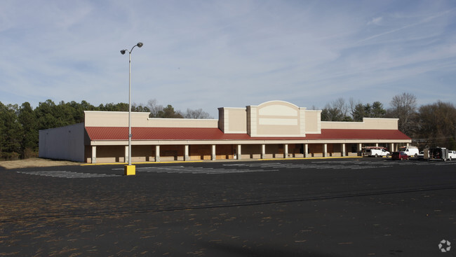

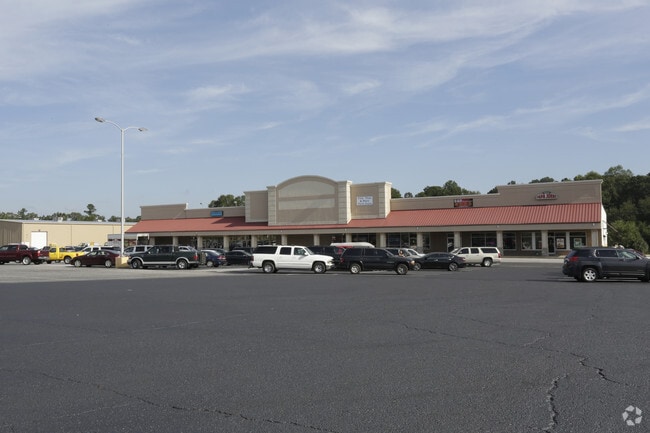
Property Detail
1428 Beaverdam Rd
Greenville-Anderson-Greer, SC
CP S 2277/2 F654 D1024 PP 100/013 LT 4 + AC BEAVERDAM RD 12.68AC
221-06-01-001
ANDERSON
Supermarket
South Carolina
B and X Area of moderate flood hazard, usually the area between the limits of the 100-year and 500-year floods.
4
2025
12.68 AC
2025
Anderson Cy S of I-85
010404
Greenville/Spartanburg
29,538 SF
NEARBY LISTINGS FOR SALE OR LEASE
DEMOGRAPHICS near 1428 Beaverdam Rd
1 mile
3 mile
5 mile
2025 Total Population
1,990
12,852
24,722
2030 Population
2,078
13,562
26,171
Pop Growth 2025-2030
+ 4.42%
+ 5.52%
+ 5.86%
Average Age
40
40
40
2025 Total Households
775
4,993
9,483
HH Growth 2025-2030
+ 4.77%
+ 5.81%
+ 6.15%
Median Household Inc
$66,857
$63,201
$64,094
Avg Household Size
2.50
2.50
2.60
2025 Avg HH Vehicles
2.00
2.00
2.00
Median Home Value
$205,797
$193,345
$205,398
Median Year Built
1983
1986
1989
Nearby Places
Map Layers
Map Styles
 Street
 Aerial
Layers
 Traffic
 Biking
Places
Listings with unknown addresses are not visible on the map
- Restaurants
- Banks
- Shops
- Fitness
- Groceries
PUBLIC TRANSPORTATION
AIRPORT
Greenville Spartanburg International
Drive
Walk
Distance
Greenville Spartanburg International
44 min
30.7 mi
Nearby Properties
Address
Land Use
TOTAL SIZE
Lot Size
Zoning
Address
Land Use
TOTAL SIZE
Lot Size
Zoning
40,884 SF
2.66 AC
Address
Land Use
TOTAL SIZE
Lot Size
Zoning
17,360 SF
5.50 AC
Address
Land Use
TOTAL SIZE
Lot Size
Zoning
19,038 SF
10.44 AC
Address
Land Use
TOTAL SIZE
Lot Size
Zoning
10.88 AC
Address
Land Use
TOTAL SIZE
Lot Size
Zoning
49,170 SF
5.10 AC
Address
Land Use
TOTAL SIZE
Lot Size
Zoning
68,962 SF
7.33 AC
Address
Land Use
TOTAL SIZE
Lot Size
Zoning
11,421 SF
1.35 AC
Address
Land Use
TOTAL SIZE
Lot Size
Zoning
6,389 SF
1.78 AC
Address
Land Use
TOTAL SIZE
Lot Size
Zoning
27,700 SF
8.99 AC
Address
Land Use
TOTAL SIZE
Lot Size
Zoning
1,546 SF
1.16 AC
Address
Land Use
TOTAL SIZE
Lot Size
Zoning
9,360 SF
1.65 AC
Address
Land Use
TOTAL SIZE
Lot Size
Zoning
13,069 SF
2.04 AC
Address
Land Use
TOTAL SIZE
Lot Size
Zoning
7,080 SF
1.59 AC
Address
Land Use
TOTAL SIZE
Lot Size
Zoning
10,032 SF
1.07 AC
Address
Land Use
TOTAL SIZE
Lot Size
Zoning
10,230 SF
1.23 AC
Address
Land Use
TOTAL SIZE
Lot Size
Zoning
3,800 SF
2.76 AC
Address
Land Use
TOTAL SIZE
Lot Size
Zoning
87,702 SF
10.07 AC
Address
Land Use
TOTAL SIZE
Lot Size
Zoning
22,080 SF
2.22 AC
Address
Land Use
TOTAL SIZE
Lot Size
Zoning
5,132 SF
2.50 AC
Address
Land Use
TOTAL SIZE
Lot Size
Zoning
8,000 SF
1.03 AC
Address
Land Use
TOTAL SIZE
Lot Size
Zoning
5,105 SF
2.52 AC
Address
Land Use
TOTAL SIZE
Lot Size
Zoning
3,224 SF
1.84 AC
Address
Land Use
TOTAL SIZE
Lot Size
Zoning
4,436 SF
0.67 AC
Address
Land Use
TOTAL SIZE
Lot Size
Zoning
124,997 SF
12.83 AC
Address
Land Use
TOTAL SIZE
Lot Size
Zoning
1,268 SF
0.93 AC
Address
Land Use
TOTAL SIZE
Lot Size
Zoning
6,505 SF
1.24 AC
Address
Land Use
TOTAL SIZE
Lot Size
Zoning
8,851 SF
179.78 AC
The World's #1 Commercial Real Estate Marketplace
Connect with us
© 2026 CoStar Group
The information above has been obtained from sources believed reliable. While we do not doubt its accuracy we have not verified it and make no guarantee, warranty or representation about it. It is your responsibility to independently confirm its accuracy and completeness. Any projections, opinions, assumptions, or estimates used are for example only and do not represent the current or future performance of the property. The value of this transaction to you depends on tax and other factors which should be evaluated by your tax, financial, and legal advisors. You and your advisors should conduct a careful, independent investigation of the property to determine to your satisfaction the suitability of the property for your needs.