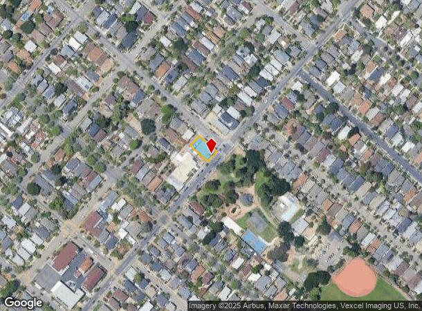
Property Record
1429 High St, Alameda, CA 94501
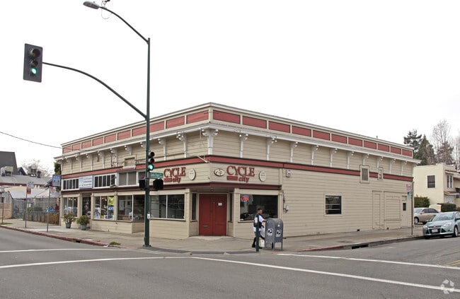


This Property Is For Sale
NEARBY LISTINGS FOR SALE OR LEASE
Property Detail
1429 High St
Oakland-Hayward-Berkeley, CA
Sather & Robinson
069-0094-004-02
LOT: 00002 BLK: 0004 AR: 0069 PAGE: 0094
Storebuilding
Alameda
X
California
06001C0088H
29
2024
0.15 AC
2025
Alameda
428100
East Bay/Oakland
4,250 SF
DEMOGRAPHICS near 1429 High St
1 Mile
3 Mile
5 Mile
2024 Total Population
19,358
212,933
459,442
2029 Population
18,718
205,533
445,531
Pop Growth 2024-2029
(3.31%)
(3.48%)
(3.03%)
Average Age
43
40
40
2024 Total Households
7,659
73,347
172,533
HH Growth 2024-2029
(3.54%)
(3.61%)
(3.06%)
Median Household Inc
$109,972
$77,406
$87,241
Avg Household Size
2.40
2.70
2.50
2024 Avg HH Vehicles
2.00
2.00
2.00
Median Home Value
$1,079,179
$832,732
$880,352
Median Year Built
1948
1952
1955
Nearby Places
Map Layers
Map Styles
 Street
 Aerial
- Restaurants
- Banks
- Shops
- Fitness
- Groceries
PUBLIC TRANSPORTATION
AIRPORT
Metro Oakland International
DRIVE
WALK
Distance
Metro Oakland International
10 min
3.9 mi
San Francisco International
DRIVE
WALK
Distance
San Francisco International
37 min
27.9 mi
Norman Y Mineta San Jose International
DRIVE
WALK
Distance
Norman Y Mineta San Jose International
40 min
37.5 mi
Nearby Properties
Address
Land Use
TOTAL SIZE
Lot Size
Zoning
Address
Land Use
TOTAL SIZE
Lot Size
Zoning
Address
Land Use
TOTAL SIZE
Lot Size
Zoning
546,164 SF
6.02 AC
Address
Land Use
TOTAL SIZE
Lot Size
Zoning
219,200 SF
5.49 AC
Address
Land Use
TOTAL SIZE
Lot Size
Zoning
371,504 SF
4.08 AC
Address
Land Use
TOTAL SIZE
Lot Size
Zoning
534,208 SF
23.18 AC
Address
Land Use
TOTAL SIZE
Lot Size
Zoning
273,623 SF
1.44 AC
Address
Land Use
TOTAL SIZE
Lot Size
Zoning
297,617 SF
1.54 AC
Address
Land Use
TOTAL SIZE
Lot Size
Zoning
259,247 SF
5.44 AC
R5PD
Address
Land Use
TOTAL SIZE
Lot Size
Zoning
190,786 SF
3.75 AC
Address
Land Use
TOTAL SIZE
Lot Size
Zoning
128,650 SF
6.38 AC
Address
Land Use
TOTAL SIZE
Lot Size
Zoning
180,959 SF
9.38 AC
Address
Land Use
TOTAL SIZE
Lot Size
Zoning
374,725 SF
18.63 AC
Address
Land Use
TOTAL SIZE
Lot Size
Zoning
336,680 SF
9.93 AC
M40
Address
Land Use
TOTAL SIZE
Lot Size
Zoning
284,255 SF
5.07 AC
Address
Land Use
TOTAL SIZE
Lot Size
Zoning
165,042 SF
13.50 AC
Address
Land Use
TOTAL SIZE
Lot Size
Zoning
169,558 SF
1.65 AC
Address
Land Use
TOTAL SIZE
Lot Size
Zoning
200,238 SF
9.28 AC
Address
Land Use
TOTAL SIZE
Lot Size
Zoning
Address
Land Use
TOTAL SIZE
Lot Size
Zoning
133,678 SF
4.33 AC
Address
Land Use
TOTAL SIZE
Lot Size
Zoning
138,196 SF
8.47 AC
Address
Land Use
TOTAL SIZE
Lot Size
Zoning
155,000 SF
8.41 AC
Address
Land Use
TOTAL SIZE
Lot Size
Zoning
136,127 SF
8.21 AC
Address
Land Use
TOTAL SIZE
Lot Size
Zoning
232,068 SF
31.82 AC
Address
Land Use
TOTAL SIZE
Lot Size
Zoning
93,964 SF
24.21 AC
Address
Land Use
TOTAL SIZE
Lot Size
Zoning
76,114 SF
6 AC
Address
Land Use
TOTAL SIZE
Lot Size
Zoning
129,726 SF
5.38 AC
Address
Land Use
TOTAL SIZE
Lot Size
Zoning
99,599 SF
3.11 AC
Address
Land Use
TOTAL SIZE
Lot Size
Zoning
0.94 AC
Address
Land Use
TOTAL SIZE
Lot Size
Zoning
197,321 SF
16.52 AC
Address
Land Use
TOTAL SIZE
Lot Size
Zoning
213,600 SF
10.60 AC
The World's #1 Commercial Real Estate Marketplace
Connect with us
© 2025 CoStar Group
The information above has been obtained from sources believed reliable. While we do not doubt its accuracy we have not verified it and make no guarantee, warranty or representation about it. It is your responsibility to independently confirm its accuracy and completeness. Any projections, opinions, assumptions, or estimates used are for example only and do not represent the current or future performance of the property. The value of this transaction to you depends on tax and other factors which should be evaluated by your tax, financial, and legal advisors. You and your advisors should conduct a careful, independent investigation of the property to determine to your satisfaction the suitability of the property for your needs.