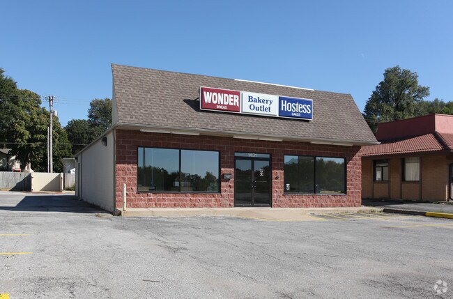
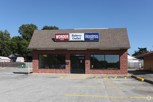
Property Record
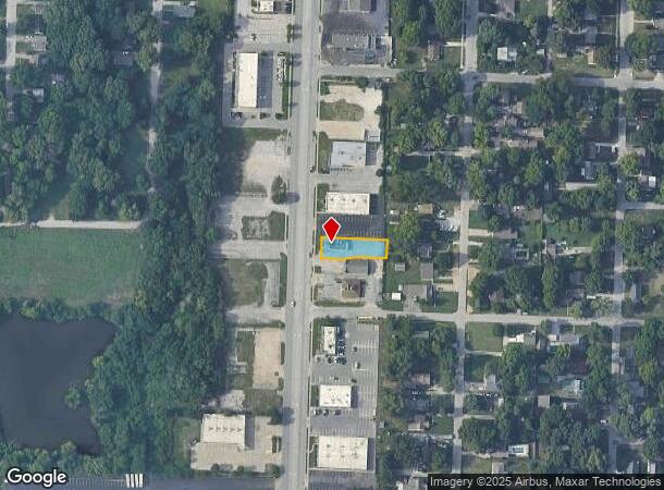
1429 S Noland Rd, Independence, MO 64055
NEARBY LISTINGS FOR SALE OR LEASE
Property Detail
1429 S Noland Rd
Kansas City, MO-KS
Gudgell Park
26-540-20-22-00-0-00-000
GUDGELL PARK REPLAT A---LOT 13-A
Storebuilding
Jackson
X
Missouri
29095C0283G
13-a
2024
0.48 AC
2025
East Jackson County
012300
Kansas City
1,768 SF
DEMOGRAPHICS near 1429 S Noland Rd
1 Mile
3 Mile
5 Mile
2024 Total Population
8,463
81,154
144,534
2029 Population
8,421
80,448
143,413
Pop Growth 2024-2029
(0.50%)
(0.87%)
(0.78%)
Average Age
41
41
41
2024 Total Households
3,505
34,207
59,954
HH Growth 2024-2029
(0.63%)
(1.04%)
(0.90%)
Median Household Inc
$48,346
$54,913
$57,446
Avg Household Size
2.30
2.30
2.30
2024 Avg HH Vehicles
2.00
2.00
2.00
Median Home Value
$141,708
$151,012
$156,855
Median Year Built
1952
1963
1967
Nearby Places
Map Layers
Map Styles
 Street
 Aerial
- Restaurants
- Banks
- Shops
- Fitness
- Groceries
PUBLIC TRANSPORTATION
COMMUTER RAIL
Independence Amtrak Station (Lincoln Service Missouri River Runner - Amtrak, Missouri River Runner - Amtrak)
DRIVE
WALK
Distance
Independence Amtrak Station (Lincoln Service Missouri River Runner - Amtrak, Missouri River Runner - Amtrak)
4 min
2.1 mi
AIRPORT
Kansas City International
DRIVE
WALK
Distance
Kansas City International
43 min
31.8 mi
Freight Ports
Tulsa Port Of Catoosa
DRIVE
WALK
Distance
Tulsa Port Of Catoosa
276 min
245.0 mi
SALE & LEASE HISTORY
LISTING DATE
SALE/LEASE

Mar 02, 2018
For Sale
Feb 12, 2019
For Lease
Feb 12, 2019
For Sale
Aug 09, 2019
For Lease
Aug 09, 2019
For Sale
Nearby Properties
Address
Land Use
TOTAL SIZE
Lot Size
Zoning
Address
Land Use
TOTAL SIZE
Lot Size
Zoning
519,315 SF
28.47 AC
Address
Land Use
TOTAL SIZE
Lot Size
Zoning
250,196 SF
39.50 AC
Address
Land Use
TOTAL SIZE
Lot Size
Zoning
455,100 SF
42.02 AC
Address
Land Use
TOTAL SIZE
Lot Size
Zoning
123,305 SF
15.51 AC
Address
Land Use
TOTAL SIZE
Lot Size
Zoning
64,318 SF
32.40 AC
Address
Land Use
TOTAL SIZE
Lot Size
Zoning
74,801 SF
8.93 AC
Address
Land Use
TOTAL SIZE
Lot Size
Zoning
210,008 SF
16.89 AC
Address
Land Use
TOTAL SIZE
Lot Size
Zoning
157,666 SF
18.54 AC
Address
Land Use
TOTAL SIZE
Lot Size
Zoning
139,713 SF
15.70 AC
Address
Land Use
TOTAL SIZE
Lot Size
Zoning
157,429 SF
36.60 AC
Address
Land Use
TOTAL SIZE
Lot Size
Zoning
42,188 SF
7.82 AC
Address
Land Use
TOTAL SIZE
Lot Size
Zoning
147,000 SF
Address
Land Use
TOTAL SIZE
Lot Size
Zoning
48,664 SF
8.44 AC
Address
Land Use
TOTAL SIZE
Lot Size
Zoning
71,339 SF
0.68 AC
Address
Land Use
TOTAL SIZE
Lot Size
Zoning
113,667 SF
6.31 AC
Address
Land Use
TOTAL SIZE
Lot Size
Zoning
190,810 SF
26.90 AC
Address
Land Use
TOTAL SIZE
Lot Size
Zoning
55,985 SF
20.93 AC
Address
Land Use
TOTAL SIZE
Lot Size
Zoning
23,925 SF
19.96 AC
Address
Land Use
TOTAL SIZE
Lot Size
Zoning
36,883 SF
14.60 AC
Address
Land Use
TOTAL SIZE
Lot Size
Zoning
45,832 SF
8.61 AC
Address
Land Use
TOTAL SIZE
Lot Size
Zoning
286,490 SF
37.30 AC
Address
Land Use
TOTAL SIZE
Lot Size
Zoning
103,866 SF
13.29 AC
Address
Land Use
TOTAL SIZE
Lot Size
Zoning
66,168 SF
44.98 AC
Address
Land Use
TOTAL SIZE
Lot Size
Zoning
45,870 SF
2.01 AC
Address
Land Use
TOTAL SIZE
Lot Size
Zoning
30,630 SF
14.08 AC
Address
Land Use
TOTAL SIZE
Lot Size
Zoning
114,248 SF
5.02 AC
Address
Land Use
TOTAL SIZE
Lot Size
Zoning
111,617 SF
9.12 AC
Address
Land Use
TOTAL SIZE
Lot Size
Zoning
111,120 SF
12.61 AC
Address
Land Use
TOTAL SIZE
Lot Size
Zoning
127,582 SF
11.22 AC
Address
Land Use
TOTAL SIZE
Lot Size
Zoning
46,125 SF
4.68 AC
The World's #1 Commercial Real Estate Marketplace
Connect with us
© 2025 CoStar Group
The information above has been obtained from sources believed reliable. While we do not doubt its accuracy we have not verified it and make no guarantee, warranty or representation about it. It is your responsibility to independently confirm its accuracy and completeness. Any projections, opinions, assumptions, or estimates used are for example only and do not represent the current or future performance of the property. The value of this transaction to you depends on tax and other factors which should be evaluated by your tax, financial, and legal advisors. You and your advisors should conduct a careful, independent investigation of the property to determine to your satisfaction the suitability of the property for your needs.