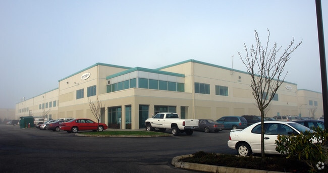
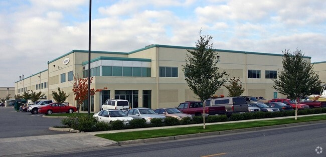
Property Record
14298 169Th Dr Se, Monroe, WA 98272


NEARBY LISTINGS FOR SALE OR LEASE
Property Detail
14298 169Th Dr Se
Seattle-Tacoma-Bellevue, WA
Fryelands Commercial/Industrial Park Div
008654-000-013-02
SECTION 35 TOWNSHIP 28 RANGE 06 QUARTER SW FRYELANDS COMMERCIAL/INDUSTRIAL PARK DIV NO 1 BLK 000 D-02 - LOT 2 CITY OF MON SP NO SP200708 REC UND AFN 200804085005 BEING SLY PTN LOT 13 SD PLAT
Warehouse
Snohomish
AE
Washington
53061C1357G
2,13
2024
3.14 AC
2025
S Snohomish County
052204
Seattle/Puget Sound
62,562 SF
DEMOGRAPHICS near 14298 169Th Dr Se
1 Mile
3 Mile
5 Mile
2024 Total Population
5,997
26,887
41,004
2029 Population
6,296
28,191
42,785
Pop Growth 2024-2029
+ 4.99%
+ 4.85%
+ 4.34%
Average Age
37
38
40
2024 Total Households
1,967
8,504
13,491
HH Growth 2024-2029
+ 5.03%
+ 5.17%
+ 4.52%
Median Household Inc
$114,207
$107,503
$116,422
Avg Household Size
3.00
2.90
2.80
2024 Avg HH Vehicles
2.00
2.00
3.00
Median Home Value
$498,591
$604,875
$680,807
Median Year Built
1995
1995
1992
Nearby Places
Map Layers
Map Styles
 Street
 Aerial
- Restaurants
- Banks
- Shops
- Fitness
- Groceries
PUBLIC TRANSPORTATION
AIRPORT
Seattle Paine Field International
DRIVE
WALK
Distance
Seattle Paine Field International
32 min
22.5 mi
Freight Ports
Port of Everett
DRIVE
WALK
Distance
Port of Everett
22 min
14.9 mi
SALE & LEASE HISTORY
LISTING DATE
SALE/LEASE

Mar 27, 2018
For Lease
Nearby Properties
Address
Land Use
TOTAL SIZE
Lot Size
Zoning
Address
Land Use
TOTAL SIZE
Lot Size
Zoning
595.90 AC
PS
Address
Land Use
TOTAL SIZE
Lot Size
Zoning
41,232 SF
88.74 AC
GC
Address
Land Use
TOTAL SIZE
Lot Size
Zoning
381,991 SF
10.41 AC
MR6000
Address
Land Use
TOTAL SIZE
Lot Size
Zoning
263,812 SF
12.64 AC
LI
Address
Land Use
TOTAL SIZE
Lot Size
Zoning
142,629 SF
8.76 AC
DC
Address
Land Use
TOTAL SIZE
Lot Size
Zoning
9.80 AC
PO
Address
Land Use
TOTAL SIZE
Lot Size
Zoning
79.16 AC
PS
Address
Land Use
TOTAL SIZE
Lot Size
Zoning
108,120 SF
10.33 AC
MR6000
Address
Land Use
TOTAL SIZE
Lot Size
Zoning
172,878 SF
15.34 AC
GC
Address
Land Use
TOTAL SIZE
Lot Size
Zoning
156,220 SF
17.30 AC
GC
Address
Land Use
TOTAL SIZE
Lot Size
Zoning
153,578 SF
5.56 AC
LI
Address
Land Use
TOTAL SIZE
Lot Size
Zoning
47,357 SF
6.82 AC
LI
Address
Land Use
TOTAL SIZE
Lot Size
Zoning
3,720 SF
46.72 AC
GC
Address
Land Use
TOTAL SIZE
Lot Size
Zoning
139,412 SF
7.08 AC
GC
Address
Land Use
TOTAL SIZE
Lot Size
Zoning
95,685 SF
4.92 AC
LI
Address
Land Use
TOTAL SIZE
Lot Size
Zoning
85,045 SF
2.87 AC
UR6000
Address
Land Use
TOTAL SIZE
Lot Size
Zoning
41,896 SF
5 AC
GC
Address
Land Use
TOTAL SIZE
Lot Size
Zoning
49,401 SF
1.69 AC
PO
Address
Land Use
TOTAL SIZE
Lot Size
Zoning
44,337 SF
4.81 AC
LI
Address
Land Use
TOTAL SIZE
Lot Size
Zoning
76,010 SF
3.59 AC
LI
Address
Land Use
TOTAL SIZE
Lot Size
Zoning
75,922 SF
3.31 AC
LI
Address
Land Use
TOTAL SIZE
Lot Size
Zoning
12.07 AC
PS
Address
Land Use
TOTAL SIZE
Lot Size
Zoning
61,900 SF
4.06 AC
GC
Address
Land Use
TOTAL SIZE
Lot Size
Zoning
65,999 SF
3.55 AC
LI
Address
Land Use
TOTAL SIZE
Lot Size
Zoning
80,800 SF
4.26 AC
LI
Address
Land Use
TOTAL SIZE
Lot Size
Zoning
45,434 SF
2.36 AC
MUC
Address
Land Use
TOTAL SIZE
Lot Size
Zoning
45,504 SF
2.67 AC
SC
Address
Land Use
TOTAL SIZE
Lot Size
Zoning
67,200 SF
3.78 AC
LI
Address
Land Use
TOTAL SIZE
Lot Size
Zoning
38,040 SF
1.74 AC
GC
The World's #1 Commercial Real Estate Marketplace
Connect with us
© 2026 CoStar Group
The information above has been obtained from sources believed reliable. While we do not doubt its accuracy we have not verified it and make no guarantee, warranty or representation about it. It is your responsibility to independently confirm its accuracy and completeness. Any projections, opinions, assumptions, or estimates used are for example only and do not represent the current or future performance of the property. The value of this transaction to you depends on tax and other factors which should be evaluated by your tax, financial, and legal advisors. You and your advisors should conduct a careful, independent investigation of the property to determine to your satisfaction the suitability of the property for your needs.