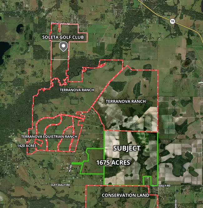
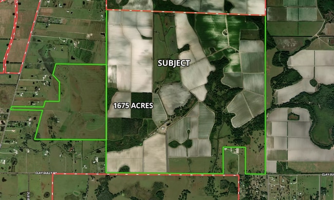
Property Record
142Nd Ave E, Myakka City, FL 34251
Current Lease Availabilities
NEARBY LISTINGS FOR SALE OR LEASE
-
-
View all Myakka City listings for lease on LoopNet.com
Property Detail
142Nd Ave E
North Port-Sarasota-Bradenton, FL
Acreage
2350-0000-7
ALL OF SEC 1 PI#2346.0000/5
Agriculturalland
Manatee
A
Florida
12081C0470E
330.68 AC
2023
Manatee Outlying
2025
Tampa/St Petersburg
002010
DEMOGRAPHICS near 142Nd Ave E
1 Mile
3 Mile
5 Mile
2024 Total Population
10
381
1,467
2029 Population
12
424
1,631
Pop Growth 2024-2029
+ 20.00%
+ 11.29%
+ 11.18%
Average Age
40
42
42
2024 Total Households
4
134
514
HH Growth 2024-2029
0.00%
+ 11.94%
+ 11.28%
Median Household Inc
$124,999
$103,125
$103,816
Avg Household Size
2.50
2.70
2.80
2024 Avg HH Vehicles
3.00
3.00
3.00
Median Home Value
$750,000
$629,310
$611,111
Median Year Built
2005
1999
1999
Nearby Places
Map Layers
Map Styles
 Street
 Aerial
- Restaurants
- Banks
- Shops
- Fitness
- Groceries
PUBLIC TRANSPORTATION
AIRPORT
Sarasota/Bradenton International
DRIVE
WALK
Distance
Sarasota/Bradenton International
57 min
36.5 mi
Freight Ports
Port Manatee
DRIVE
WALK
Distance
Port Manatee
62 min
42.4 mi
Nearby Properties
Address
Land Use
TOTAL SIZE
Lot Size
Zoning
Address
Land Use
TOTAL SIZE
Lot Size
Zoning
70,504 SF
101.09 AC
A GENERAL
Address
Land Use
TOTAL SIZE
Lot Size
Zoning
68,266 SF
92.56 AC
A GENERAL
Address
Land Use
TOTAL SIZE
Lot Size
Zoning
191 AC
A GENERAL
Address
Land Use
TOTAL SIZE
Lot Size
Zoning
440.80 AC
A GENERAL
Address
Land Use
TOTAL SIZE
Lot Size
Zoning
25,794 SF
894.30 AC
Address
Land Use
TOTAL SIZE
Lot Size
Zoning
253.68 AC
A GENERAL
Address
Land Use
TOTAL SIZE
Lot Size
Zoning
130 AC
A GENERAL
Address
Land Use
TOTAL SIZE
Lot Size
Zoning
297 SF
1,508.20 AC
A GENERAL
Address
Land Use
TOTAL SIZE
Lot Size
Zoning
14,524 SF
46.16 AC
A GENERAL
Address
Land Use
TOTAL SIZE
Lot Size
Zoning
4,963 SF
5.31 AC
A GENERAL
Address
Land Use
TOTAL SIZE
Lot Size
Zoning
8,548 SF
244.26 AC
A GENERAL
Address
Land Use
TOTAL SIZE
Lot Size
Zoning
5,188 SF
24.72 AC
A GENERAL
Address
Land Use
TOTAL SIZE
Lot Size
Zoning
11,210 SF
125.87 AC
A GENERAL
Address
Land Use
TOTAL SIZE
Lot Size
Zoning
643.10 AC
A GENERAL
Address
Land Use
TOTAL SIZE
Lot Size
Zoning
214.60 AC
A GENERAL
Address
Land Use
TOTAL SIZE
Lot Size
Zoning
3,288 SF
5.03 AC
A GENERAL
Address
Land Use
TOTAL SIZE
Lot Size
Zoning
5,800 SF
7.26 AC
A GENERAL
Address
Land Use
TOTAL SIZE
Lot Size
Zoning
13,125 SF
621 AC
A GENERAL
Address
Land Use
TOTAL SIZE
Lot Size
Zoning
6,240 SF
17.43 AC
A GENERAL
Address
Land Use
TOTAL SIZE
Lot Size
Zoning
2,290 SF
88.06 AC
A GENERAL
Address
Land Use
TOTAL SIZE
Lot Size
Zoning
4,748 SF
100 AC
A GENERAL
Address
Land Use
TOTAL SIZE
Lot Size
Zoning
4,942 SF
19.90 AC
A GENERAL
Address
Land Use
TOTAL SIZE
Lot Size
Zoning
Address
Land Use
TOTAL SIZE
Lot Size
Zoning
3,592 SF
6.26 AC
A GENERAL
Address
Land Use
TOTAL SIZE
Lot Size
Zoning
655 AC
A GENERAL
Address
Land Use
TOTAL SIZE
Lot Size
Zoning
10,389 SF
285.81 AC
A GENERAL
Address
Land Use
TOTAL SIZE
Lot Size
Zoning
4,328 SF
102.28 AC
A GENERAL
Address
Land Use
TOTAL SIZE
Lot Size
Zoning
15.01 AC
A GENERAL
Address
Land Use
TOTAL SIZE
Lot Size
Zoning
50.03 AC
A GENERAL
The World's #1 Commercial Real Estate Marketplace
Connect with us
© 2025 CoStar Group
The information above has been obtained from sources believed reliable. While we do not doubt its accuracy we have not verified it and make no guarantee, warranty or representation about it. It is your responsibility to independently confirm its accuracy and completeness. Any projections, opinions, assumptions, or estimates used are for example only and do not represent the current or future performance of the property. The value of this transaction to you depends on tax and other factors which should be evaluated by your tax, financial, and legal advisors. You and your advisors should conduct a careful, independent investigation of the property to determine to your satisfaction the suitability of the property for your needs.