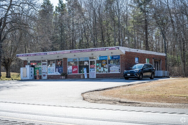
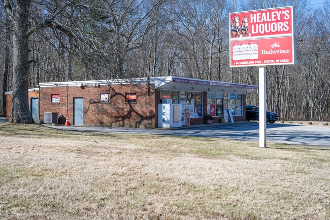
Property Record
143 Danielson Pike, Foster, RI 02825

Save to a Folder
{{folder.Name}}
{{folder.ListingIds.length}} Properties
{{folder.ListingIds.length}} Property
Create a New Folder
Property Detail
143 Danielson Pike
FOST-000011-000000-000019-B000000
PROVIDENCE
Commercialnec
Rhode Island
1
19-b
B and X Area of moderate flood hazard, usually the area between the limits of the 100-year and 500-year floods.
2.30 AC
2025
Foster/Scituate
2025
Providence
013300
Providence-Warwick, RI-MA
552 SF
NEARBY LISTINGS FOR SALE OR LEASE
-
-
View all Foster listings for sale on LoopNet.com
DEMOGRAPHICS near 143 Danielson Pike
1 mile
3 mile
5 mile
2025 Total Population
310
2,585
9,477
2030 Population
312
2,606
9,701
Pop Growth 2025-2030
+ 0.65%
+ 0.81%
+ 2.36%
Average Age
46
45
45
2025 Total Households
122
1,012
3,728
HH Growth 2025-2030
+ 0.82%
+ 0.79%
+ 2.36%
Median Household Inc
$113,690
$108,847
$104,377
Avg Household Size
2.50
2.50
2.50
2025 Avg HH Vehicles
2.00
2.00
2.00
Median Home Value
$424,545
$420,238
$388,377
Median Year Built
1971
1972
1976
Nearby Places
Map Layers
Map Styles
 Street
 Aerial
Layers
 Traffic
 Biking
Places
Listings with unknown addresses are not visible on the map
- Restaurants
- Banks
- Shops
- Fitness
- Groceries
PUBLIC TRANSPORTATION
AIRPORT
Rhode Island Tf Green International
Drive
Walk
Distance
Rhode Island Tf Green International
34 min
24.1 mi
Worcester Regional
Drive
Walk
Distance
Worcester Regional
58 min
43.5 mi
Freight Ports
Port of Davisville, RI
Drive
Walk
Distance
Port of Davisville, RI
45 min
33.3 mi
SALE & LEASE HISTORY
LISTING DATE
SALE/LEASE

Feb 18, 2025
For Sale
Nearby Properties
Address
Land Use
TOTAL SIZE
Lot Size
Zoning
Address
Land Use
TOTAL SIZE
Lot Size
Zoning
50,170 SF
17.22 AC
30
Address
Land Use
TOTAL SIZE
Lot Size
Zoning
6,250 SF
225 AC
RD
Address
Land Use
TOTAL SIZE
Lot Size
Zoning
2,386 SF
19 AC
20
Address
Land Use
TOTAL SIZE
Lot Size
Zoning
161.15 AC
30
Address
Land Use
TOTAL SIZE
Lot Size
Zoning
4,528 SF
7.10 AC
1
Address
Land Use
TOTAL SIZE
Lot Size
Zoning
120 AC
30
Address
Land Use
TOTAL SIZE
Lot Size
Zoning
6,820 SF
4.56 AC
20
Address
Land Use
TOTAL SIZE
Lot Size
Zoning
9,828 SF
10.16 AC
1
Address
Land Use
TOTAL SIZE
Lot Size
Zoning
7,732 SF
14 AC
30
Address
Land Use
TOTAL SIZE
Lot Size
Zoning
5,562 SF
0.14 AC
30
Address
Land Use
TOTAL SIZE
Lot Size
Zoning
80 AC
30
Address
Land Use
TOTAL SIZE
Lot Size
Zoning
2,000 SF
2.17 AC
30
Address
Land Use
TOTAL SIZE
Lot Size
Zoning
1,161 SF
6.10 AC
1
Address
Land Use
TOTAL SIZE
Lot Size
Zoning
1,696 SF
5 AC
1
Address
Land Use
TOTAL SIZE
Lot Size
Zoning
1,638 SF
2.75 AC
30
Address
Land Use
TOTAL SIZE
Lot Size
Zoning
1,728 SF
13.01 AC
1
Address
Land Use
TOTAL SIZE
Lot Size
Zoning
2,497 SF
62.20 AC
30
Address
Land Use
TOTAL SIZE
Lot Size
Zoning
12,108 SF
1.08 AC
BL V
Address
Land Use
TOTAL SIZE
Lot Size
Zoning
4,208 SF
0.50 AC
30
Address
Land Use
TOTAL SIZE
Lot Size
Zoning
1,447 SF
2.30 AC
60
Address
Land Use
TOTAL SIZE
Lot Size
Zoning
1,560 SF
0.64 AC
30
Address
Land Use
TOTAL SIZE
Lot Size
Zoning
2,016 SF
15.69 AC
30
Address
Land Use
TOTAL SIZE
Lot Size
Zoning
2,559 SF
6.62 AC
30
Address
Land Use
TOTAL SIZE
Lot Size
Zoning
768 SF
5.30 AC
1
Address
Land Use
TOTAL SIZE
Lot Size
Zoning
1,875 SF
32.14 AC
30
Address
Land Use
TOTAL SIZE
Lot Size
Zoning
3,168 SF
0.50 AC
30
Address
Land Use
TOTAL SIZE
Lot Size
Zoning
2,286 SF
40.04 AC
30
Address
Land Use
TOTAL SIZE
Lot Size
Zoning
1,184 SF
2 AC
1
Address
Land Use
TOTAL SIZE
Lot Size
Zoning
1,793 SF
1 AC
1
Address
Land Use
TOTAL SIZE
Lot Size
Zoning
1,386 SF
0.62 AC
1
The World's #1 Commercial Real Estate Marketplace
Connect with us
© 2026 CoStar Group
The information above has been obtained from sources believed reliable. While we do not doubt its accuracy we have not verified it and make no guarantee, warranty or representation about it. It is your responsibility to independently confirm its accuracy and completeness. Any projections, opinions, assumptions, or estimates used are for example only and do not represent the current or future performance of the property. The value of this transaction to you depends on tax and other factors which should be evaluated by your tax, financial, and legal advisors. You and your advisors should conduct a careful, independent investigation of the property to determine to your satisfaction the suitability of the property for your needs.