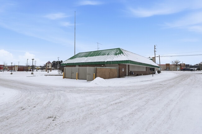
Property Record
143 Division St N, Stevens Point, WI 54481

NEARBY LISTINGS FOR SALE OR LEASE
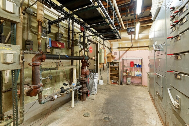
Property Detail
143 Division St N
Stevens Point, WI
LOT 1 CSM#3116-11- 74 BNG PRT LOT 2 CSM 2/125 & SE NE & ING/EGR ESMT AS DESC IN 775408 & 783073 S29 T24 R8 452/1149-52;775408
281-24-0829140014
Portage
Commercialnec
Wisconsin
X
1-2
55097C0212D
1.15 AC
2024
Wausau/Stevens Point
2024
Other Market Areas
960400
DEMOGRAPHICS near 143 Division St N
1 Mile
3 Mile
5 Mile
2024 Total Population
9,433
27,152
40,209
2029 Population
9,575
27,620
40,857
Pop Growth 2024-2029
+ 1.51%
+ 1.72%
+ 1.61%
Average Age
31
37
39
2024 Total Households
3,270
11,471
16,938
HH Growth 2024-2029
+ 1.77%
+ 1.90%
+ 1.75%
Median Household Inc
$33,038
$52,460
$60,100
Avg Household Size
2.00
2.10
2.20
2024 Avg HH Vehicles
2.00
2.00
2.00
Median Home Value
$143,722
$161,995
$175,737
Median Year Built
1961
1970
1976
Nearby Places
Map Layers
Map Styles
 Street
 Aerial
- Restaurants
- Banks
- Shops
- Fitness
- Groceries
PUBLIC TRANSPORTATION
AIRPORT
Central Wisconsin
DRIVE
WALK
Distance
Central Wisconsin
23 min
18.0 mi
Freight Ports
Port Milwaukee
DRIVE
WALK
Distance
Port Milwaukee
187 min
158.5 mi
Nearby Properties
Address
Land Use
TOTAL SIZE
Lot Size
Zoning
Address
Land Use
TOTAL SIZE
Lot Size
Zoning
13.17 AC
Address
Land Use
TOTAL SIZE
Lot Size
Zoning
85.85 AC
Address
Land Use
TOTAL SIZE
Lot Size
Zoning
13.14 AC
Address
Land Use
TOTAL SIZE
Lot Size
Zoning
Address
Land Use
TOTAL SIZE
Lot Size
Zoning
260.24 AC
Address
Land Use
TOTAL SIZE
Lot Size
Zoning
Address
Land Use
TOTAL SIZE
Lot Size
Zoning
22.22 AC
Address
Land Use
TOTAL SIZE
Lot Size
Zoning
Address
Land Use
TOTAL SIZE
Lot Size
Zoning
Address
Land Use
TOTAL SIZE
Lot Size
Zoning
Address
Land Use
TOTAL SIZE
Lot Size
Zoning
Address
Land Use
TOTAL SIZE
Lot Size
Zoning
Address
Land Use
TOTAL SIZE
Lot Size
Zoning
3.54 AC
Address
Land Use
TOTAL SIZE
Lot Size
Zoning
Address
Land Use
TOTAL SIZE
Lot Size
Zoning
Address
Land Use
TOTAL SIZE
Lot Size
Zoning
9.19 AC
Address
Land Use
TOTAL SIZE
Lot Size
Zoning
11.97 AC
Address
Land Use
TOTAL SIZE
Lot Size
Zoning
Address
Land Use
TOTAL SIZE
Lot Size
Zoning
7.78 AC
Address
Land Use
TOTAL SIZE
Lot Size
Zoning
10.04 AC
Address
Land Use
TOTAL SIZE
Lot Size
Zoning
Address
Land Use
TOTAL SIZE
Lot Size
Zoning
0.92 AC
Address
Land Use
TOTAL SIZE
Lot Size
Zoning
1.12 AC
Address
Land Use
TOTAL SIZE
Lot Size
Zoning
Address
Land Use
TOTAL SIZE
Lot Size
Zoning
Address
Land Use
TOTAL SIZE
Lot Size
Zoning
Address
Land Use
TOTAL SIZE
Lot Size
Zoning
3.17 AC
Address
Land Use
TOTAL SIZE
Lot Size
Zoning
21.77 AC
Address
Land Use
TOTAL SIZE
Lot Size
Zoning
Address
Land Use
TOTAL SIZE
Lot Size
Zoning
10.58 AC
The World's #1 Commercial Real Estate Marketplace
Connect with us
© 2025 CoStar Group
The information above has been obtained from sources believed reliable. While we do not doubt its accuracy we have not verified it and make no guarantee, warranty or representation about it. It is your responsibility to independently confirm its accuracy and completeness. Any projections, opinions, assumptions, or estimates used are for example only and do not represent the current or future performance of the property. The value of this transaction to you depends on tax and other factors which should be evaluated by your tax, financial, and legal advisors. You and your advisors should conduct a careful, independent investigation of the property to determine to your satisfaction the suitability of the property for your needs.