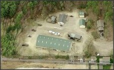
Property Record
143 Runnells Bridge Rd, Hollis, NH 03049


NEARBY LISTINGS FOR SALE OR LEASE
Property Detail
143 Runnells Bridge Rd
Commercialofficeresidentialmixeduse
Hillsborough
X
New Hampshire
25017C0079F
4.75 AC
2024
Hillsborough
2024
Boston
017101
Manchester-Nashua, NH
2,221 SF
HOLS-000004-000000-000064
DEMOGRAPHICS near 143 Runnells Bridge Rd
1 Mile
3 Mile
5 Mile
2024 Total Population
1,635
15,410
60,146
2029 Population
1,641
15,485
60,769
Pop Growth 2024-2029
+ 0.37%
+ 0.49%
+ 1.04%
Average Age
45
43
43
2024 Total Households
609
5,889
23,583
HH Growth 2024-2029
+ 0.33%
+ 0.49%
+ 1.04%
Median Household Inc
$146,686
$117,429
$113,447
Avg Household Size
2.70
2.60
2.50
2024 Avg HH Vehicles
2.00
2.00
2.00
Median Home Value
$497,958
$430,916
$405,233
Median Year Built
1991
1981
1980
Nearby Places
Map Layers
Map Styles
 Street
 Aerial
- Restaurants
- Banks
- Shops
- Fitness
- Groceries
PUBLIC TRANSPORTATION
AIRPORT
Manchester Boston Regional
DRIVE
WALK
Distance
Manchester Boston Regional
33 min
20.2 mi
Freight Ports
Port of Boston
DRIVE
WALK
Distance
Port of Boston
75 min
52.9 mi
SALE & LEASE HISTORY
LISTING DATE
SALE/LEASE

Sep 23, 2016
For Sale
Mar 16, 2017
For Sale
Apr 12, 2018
For Sale
Nearby Properties
Address
Land Use
TOTAL SIZE
Lot Size
Zoning
Address
Land Use
TOTAL SIZE
Lot Size
Zoning
127,577 SF
77.91 AC
TNR
Address
Land Use
TOTAL SIZE
Lot Size
Zoning
129,435 SF
29.90 AC
TNR
Address
Land Use
TOTAL SIZE
Lot Size
Zoning
42.06 AC
IND
Address
Land Use
TOTAL SIZE
Lot Size
Zoning
5.02 AC
SUR
Address
Land Use
TOTAL SIZE
Lot Size
Zoning
153,429 SF
76 AC
TC
Address
Land Use
TOTAL SIZE
Lot Size
Zoning
1,440 SF
111.23 AC
R9
Address
Land Use
TOTAL SIZE
Lot Size
Zoning
8.32 AC
URR
Address
Land Use
TOTAL SIZE
Lot Size
Zoning
297.34 AC
R30
Address
Land Use
TOTAL SIZE
Lot Size
Zoning
64,987 SF
58 AC
R30
Address
Land Use
TOTAL SIZE
Lot Size
Zoning
12.43 AC
R40
Address
Land Use
TOTAL SIZE
Lot Size
Zoning
9.16 AC
IND
Address
Land Use
TOTAL SIZE
Lot Size
Zoning
2.88 AC
COM
Address
Land Use
TOTAL SIZE
Lot Size
Zoning
28,720 SF
11.58 AC
R9
Address
Land Use
TOTAL SIZE
Lot Size
Zoning
51.83 AC
R9
Address
Land Use
TOTAL SIZE
Lot Size
Zoning
12.63 AC
R9
Address
Land Use
TOTAL SIZE
Lot Size
Zoning
13.19 AC
SUR
Address
Land Use
TOTAL SIZE
Lot Size
Zoning
180,434 SF
10.94 AC
IND
Address
Land Use
TOTAL SIZE
Lot Size
Zoning
1,288 SF
31.64 AC
R9
Address
Land Use
TOTAL SIZE
Lot Size
Zoning
12.07 AC
R40
Address
Land Use
TOTAL SIZE
Lot Size
Zoning
6.69 AC
R30
Address
Land Use
TOTAL SIZE
Lot Size
Zoning
3,023 SF
16 AC
RA
Address
Land Use
TOTAL SIZE
Lot Size
Zoning
9 AC
R9
Address
Land Use
TOTAL SIZE
Lot Size
Zoning
2,307 SF
1.50 AC
URR
Address
Land Use
TOTAL SIZE
Lot Size
Zoning
175.67 AC
RUR
Address
Land Use
TOTAL SIZE
Lot Size
Zoning
80.04 AC
R40
Address
Land Use
TOTAL SIZE
Lot Size
Zoning
41,336 SF
3.90 AC
IND
Address
Land Use
TOTAL SIZE
Lot Size
Zoning
9,634 SF
R30
Address
Land Use
TOTAL SIZE
Lot Size
Zoning
23,720 SF
4.19 AC
IN
Address
Land Use
TOTAL SIZE
Lot Size
Zoning
34,620 SF
6.02 AC
IN
Address
Land Use
TOTAL SIZE
Lot Size
Zoning
16,939 SF
1 AC
URR
The World's #1 Commercial Real Estate Marketplace
Connect with us
© 2026 CoStar Group
The information above has been obtained from sources believed reliable. While we do not doubt its accuracy we have not verified it and make no guarantee, warranty or representation about it. It is your responsibility to independently confirm its accuracy and completeness. Any projections, opinions, assumptions, or estimates used are for example only and do not represent the current or future performance of the property. The value of this transaction to you depends on tax and other factors which should be evaluated by your tax, financial, and legal advisors. You and your advisors should conduct a careful, independent investigation of the property to determine to your satisfaction the suitability of the property for your needs.