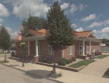
Property Record
143 S Main St, Lewistown, IL 61542
NEARBY LISTINGS FOR SALE OR LEASE
-
-
View all Lewistown listings for sale on LoopNet.com
Property Detail
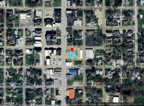
143 S Main St
18-19-223-530-17
LOT 151 ORIGINAL TOWN 39' W END 117 & 118 S 20' E 60' 118 ALL LOTS 150 &
Commercialnec
Fulton
X
Illinois
17057C0320E
151
2024
0.46 AC
2024
Other Market Areas
953800
Canton, IL
DEMOGRAPHICS near 143 S Main St
1 Mile
3 Mile
5 Mile
2024 Total Population
2,556
2,874
3,245
2029 Population
2,555
2,865
3,218
Pop Growth 2024-2029
(0.04%)
(0.31%)
(0.83%)
Average Age
44
45
45
2024 Total Households
1,175
1,318
1,480
HH Growth 2024-2029
(0.09%)
(0.38%)
(0.88%)
Median Household Inc
$65,318
$66,497
$66,854
Avg Household Size
2.10
2.10
2.10
2024 Avg HH Vehicles
2.00
2.00
2.00
Median Home Value
$90,866
$94,315
$99,043
Median Year Built
1970
1970
1970
Nearby Places
Map Layers
Map Styles
 Street
 Aerial
- Restaurants
- Banks
- Shops
- Fitness
- Groceries
PUBLIC TRANSPORTATION
AIRPORT
General Downing - Peoria International
DRIVE
WALK
Distance
General Downing - Peoria International
60 min
40.4 mi
Nearby Properties
Address
Land Use
TOTAL SIZE
Lot Size
Zoning
Address
Land Use
TOTAL SIZE
Lot Size
Zoning
0.91 AC
Address
Land Use
TOTAL SIZE
Lot Size
Zoning
1.39 AC
Address
Land Use
TOTAL SIZE
Lot Size
Zoning
7,812 SF
2.40 AC
Address
Land Use
TOTAL SIZE
Lot Size
Zoning
Address
Land Use
TOTAL SIZE
Lot Size
Zoning
5.45 AC
Address
Land Use
TOTAL SIZE
Lot Size
Zoning
7,422 SF
63.07 AC
Address
Land Use
TOTAL SIZE
Lot Size
Zoning
4,032 SF
119.31 AC
Address
Land Use
TOTAL SIZE
Lot Size
Zoning
6,600 SF
100.15 AC
Address
Land Use
TOTAL SIZE
Lot Size
Zoning
1.15 AC
Address
Land Use
TOTAL SIZE
Lot Size
Zoning
156.76 AC
Address
Land Use
TOTAL SIZE
Lot Size
Zoning
2,928 SF
81.49 AC
Address
Land Use
TOTAL SIZE
Lot Size
Zoning
3,424 SF
37.32 AC
Address
Land Use
TOTAL SIZE
Lot Size
Zoning
160.64 AC
Address
Land Use
TOTAL SIZE
Lot Size
Zoning
1.74 AC
Address
Land Use
TOTAL SIZE
Lot Size
Zoning
1.74 AC
Address
Land Use
TOTAL SIZE
Lot Size
Zoning
0.40 AC
Address
Land Use
TOTAL SIZE
Lot Size
Zoning
200.13 AC
Address
Land Use
TOTAL SIZE
Lot Size
Zoning
216.70 AC
Address
Land Use
TOTAL SIZE
Lot Size
Zoning
1,976 SF
1.58 AC
Address
Land Use
TOTAL SIZE
Lot Size
Zoning
3,600 SF
200.04 AC
Address
Land Use
TOTAL SIZE
Lot Size
Zoning
3,204 SF
82.82 AC
Address
Land Use
TOTAL SIZE
Lot Size
Zoning
42.85 AC
Address
Land Use
TOTAL SIZE
Lot Size
Zoning
10,282 SF
39.41 AC
Address
Land Use
TOTAL SIZE
Lot Size
Zoning
4,492 SF
0.89 AC
Address
Land Use
TOTAL SIZE
Lot Size
Zoning
3,055 SF
11.78 AC
Address
Land Use
TOTAL SIZE
Lot Size
Zoning
Address
Land Use
TOTAL SIZE
Lot Size
Zoning
2,520 SF
159.61 AC
Address
Land Use
TOTAL SIZE
Lot Size
Zoning
0.51 AC
Address
Land Use
TOTAL SIZE
Lot Size
Zoning
191.43 AC
The World's #1 Commercial Real Estate Marketplace
Connect with us
© 2025 CoStar Group
The information above has been obtained from sources believed reliable. While we do not doubt its accuracy we have not verified it and make no guarantee, warranty or representation about it. It is your responsibility to independently confirm its accuracy and completeness. Any projections, opinions, assumptions, or estimates used are for example only and do not represent the current or future performance of the property. The value of this transaction to you depends on tax and other factors which should be evaluated by your tax, financial, and legal advisors. You and your advisors should conduct a careful, independent investigation of the property to determine to your satisfaction the suitability of the property for your needs.