Property Record
1430 Nw 20Th St, Miami, FL 33142

NEARBY LISTINGS FOR SALE OR LEASE
-
-
-
-
-
-
-
1150-1180 8th St. Rd; 1008-1080 Spring Garden Rd
Miami, FL 33136
Rent Upon Request
2.94 AC Lots
Land
-
-
-
-
-
-
-
-
-
-
-
-
-
-
-
-
-
-
-
-
-
-
-
-
View all Miami listings for sale on LoopNet.com
Property Detail
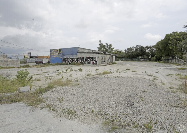
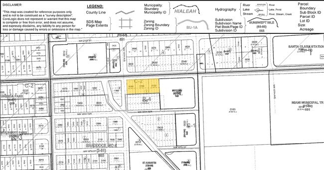
1430 Nw 20Th St
Miami-Miami Beach-Kendall, FL
Braddocks Sub No 4
01-3135-005-0120
BRADDOCKS SUB NO 4 PB 3-61 LOTS 19 THRU 30 BLK 1 LESS N10FT FOR R/W & N1/2 OF ALLEY LYG S & ADJ CLOSED PER ORD 13492 LESS EXT AREA OF CURVE IN NW COR FOR R/W LOT SIZE 39767 SQ FT M/L
Financialbuilding
Miami/Dade
AE
Florida
12086C0311L
19-30
2024
0.91 AC
2025
Miami
003004
South Florida
7,660 SF
DEMOGRAPHICS near 1430 Nw 20Th St
1 Mile
3 Mile
5 Mile
2024 Total Population
34,252
337,319
587,910
2029 Population
33,693
334,194
579,590
Pop Growth 2024-2029
(1.63%)
(0.93%)
(1.42%)
Average Age
42
40
41
2024 Total Households
13,224
140,946
242,459
HH Growth 2024-2029
(1.52%)
(0.95%)
(1.41%)
Median Household Inc
$27,471
$47,715
$51,716
Avg Household Size
2.30
2.30
2.30
2024 Avg HH Vehicles
1.00
1.00
1.00
Median Home Value
$341,416
$390,507
$415,842
Median Year Built
1972
1984
1975
Nearby Places
Map Layers
Map Styles
 Street
 Aerial
- Restaurants
- Banks
- Shops
- Fitness
- Groceries
PUBLIC TRANSPORTATION
COMMUTER RAIL
Santa Clara (Metrorail Green Line - Miami-Dade Transit (Metrorail/Metromover))
DRIVE
WALK
Distance
Santa Clara (Metrorail Green Line - Miami-Dade Transit (Metrorail/Metromover))
1 min
9 min
0.4 mi
Civic Center (Metrorail Green Line - Miami-Dade Transit (Metrorail/Metromover), REGULAR METRORAIL SERVICE - Miami-Dade Transit (Metrorail/Metromover))
DRIVE
WALK
Distance
Civic Center (Metrorail Green Line - Miami-Dade Transit (Metrorail/Metromover), REGULAR METRORAIL SERVICE - Miami-Dade Transit (Metrorail/Metromover))
2 min
13 min
0.7 mi
AIRPORT
Miami International
DRIVE
WALK
Distance
Miami International
19 min
7.8 mi
Fort Lauderdale/Hollywood International
DRIVE
WALK
Distance
Fort Lauderdale/Hollywood International
35 min
23.7 mi
Freight Ports
Port of Miami
DRIVE
WALK
Distance
Port of Miami
12 min
5.0 mi
SALE & LEASE HISTORY
LISTING DATE
SALE/LEASE

Sep 24, 2016
For Sale
Oct 30, 2017
For Sale
Oct 25, 2017
For Sale
Nov 02, 2017
For Sale
May 18, 2017
For Sale
Jul 15, 2017
For Sale
Nearby Properties
Address
Land Use
TOTAL SIZE
Lot Size
Zoning
Address
Land Use
TOTAL SIZE
Lot Size
Zoning
1,050,691 SF
0.83 AC
6408
Address
Land Use
TOTAL SIZE
Lot Size
Zoning
955,966 SF
38.91 AC
9600
Address
Land Use
TOTAL SIZE
Lot Size
Zoning
2,559,318 SF
2.21 AC
6407
Address
Land Use
TOTAL SIZE
Lot Size
Zoning
2,039,308 SF
2.46 AC
6401
Address
Land Use
TOTAL SIZE
Lot Size
Zoning
928,000 SF
14.30 AC
8000
Address
Land Use
TOTAL SIZE
Lot Size
Zoning
1,110,657 SF
3.83 AC
6407
Address
Land Use
TOTAL SIZE
Lot Size
Zoning
16.13 AC
6100
Address
Land Use
TOTAL SIZE
Lot Size
Zoning
2,789,683 SF
33.23 AC
7300
Address
Land Use
TOTAL SIZE
Lot Size
Zoning
1,346,294 SF
1.89 AC
6408
Address
Land Use
TOTAL SIZE
Lot Size
Zoning
2,403,353 SF
7.37 AC
6100
Address
Land Use
TOTAL SIZE
Lot Size
Zoning
1,938,271 SF
6.62 AC
6402
Address
Land Use
TOTAL SIZE
Lot Size
Zoning
1,075,124 SF
1.61 AC
6405
Address
Land Use
TOTAL SIZE
Lot Size
Zoning
1,544,491 SF
0.97 AC
6401
Address
Land Use
TOTAL SIZE
Lot Size
Zoning
782,686 SF
0.06 AC
6401
Address
Land Use
TOTAL SIZE
Lot Size
Zoning
1,657,362 SF
1.15 AC
6401
Address
Land Use
TOTAL SIZE
Lot Size
Zoning
1,072,012 SF
1.78 AC
6407
Address
Land Use
TOTAL SIZE
Lot Size
Zoning
244,533 SF
3.53 AC
6600
Address
Land Use
TOTAL SIZE
Lot Size
Zoning
694,863 SF
1.90 AC
6407
Address
Land Use
TOTAL SIZE
Lot Size
Zoning
656,821 SF
2.06 AC
6407
Address
Land Use
TOTAL SIZE
Lot Size
Zoning
303,989 SF
1.47 AC
6600
Address
Land Use
TOTAL SIZE
Lot Size
Zoning
416,675 SF
6.48 AC
6401
Address
Land Use
TOTAL SIZE
Lot Size
Zoning
256,089 SF
20.35 AC
7600
Address
Land Use
TOTAL SIZE
Lot Size
Zoning
1,004,006 SF
0.92 AC
6401
Address
Land Use
TOTAL SIZE
Lot Size
Zoning
2.50 AC
6407
Address
Land Use
TOTAL SIZE
Lot Size
Zoning
585,775 SF
1.86 AC
6101
Address
Land Use
TOTAL SIZE
Lot Size
Zoning
868,860 SF
2.14 AC
6402
Address
Land Use
TOTAL SIZE
Lot Size
Zoning
491,308 SF
0.14 AC
6401
Address
Land Use
TOTAL SIZE
Lot Size
Zoning
903,993 SF
0.60 AC
6412
Address
Land Use
TOTAL SIZE
Lot Size
Zoning
872,245 SF
0.56 AC
6401
Address
Land Use
TOTAL SIZE
Lot Size
Zoning
615,785 SF
3.81 AC
4604
The World's #1 Commercial Real Estate Marketplace
Connect with us
© 2025 CoStar Group
The information above has been obtained from sources believed reliable. While we do not doubt its accuracy we have not verified it and make no guarantee, warranty or representation about it. It is your responsibility to independently confirm its accuracy and completeness. Any projections, opinions, assumptions, or estimates used are for example only and do not represent the current or future performance of the property. The value of this transaction to you depends on tax and other factors which should be evaluated by your tax, financial, and legal advisors. You and your advisors should conduct a careful, independent investigation of the property to determine to your satisfaction the suitability of the property for your needs.