Property Record
1430 4Th St, Beloit, WI 53511
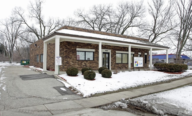

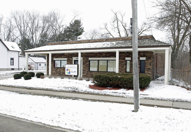
Property Detail
1430 4Th St
126-30400
N 110 FT OF THE S 534.5 FT B 1 DOWS ADD
Vacantlandexempt
ROCK
C and X Area of minimal flood hazard, usually depicted on FIRMs as above the 500-year flood level.
Wisconsin
0
0.56 AC
2025
Rock County
001700
Milwaukee/Madison
2,990 SF
Janesville-Beloit, WI
NEARBY LISTINGS FOR SALE OR LEASE
DEMOGRAPHICS near 1430 4Th St
1 mile
3 mile
5 mile
2025 Total Population
12,152
47,734
65,308
2030 Population
12,231
48,116
65,880
Pop Growth 2025-2030
+ 0.65%
+ 0.80%
+ 0.88%
Average Age
36
39
40
2025 Total Households
4,441
18,629
25,436
HH Growth 2025-2030
+ 0.65%
+ 0.81%
+ 0.89%
Median Household Inc
$48,223
$61,279
$68,763
Avg Household Size
2.60
2.40
2.40
2025 Avg HH Vehicles
2.00
2.00
2.00
Median Home Value
$135,110
$167,749
$185,047
Median Year Built
1949
1959
1966
Nearby Places
Map Layers
Map Styles
 Street
 Aerial
Transit
 Traffic
 Biking
Places
Listings with unknown addresses are not visible on the map
- Restaurants
- Banks
- Shops
- Fitness
- Groceries
PUBLIC TRANSPORTATION
AIRPORT
Chicago/Rockford International
Drive
Walk
Distance
Chicago/Rockford International
45 min
32.9 mi
Freight Ports
Port Milwaukee
Drive
Walk
Distance
Port Milwaukee
89 min
74.5 mi
Nearby Properties
Address
Land Use
TOTAL SIZE
Lot Size
Zoning
Address
Land Use
TOTAL SIZE
Lot Size
Zoning
24.76 AC
Address
Land Use
TOTAL SIZE
Lot Size
Zoning
202,676 SF
19.31 AC
Address
Land Use
TOTAL SIZE
Lot Size
Zoning
61,820 SF
5.63 AC
Address
Land Use
TOTAL SIZE
Lot Size
Zoning
103,761 SF
21.59 AC
Address
Land Use
TOTAL SIZE
Lot Size
Zoning
7.71 AC
Address
Land Use
TOTAL SIZE
Lot Size
Zoning
186,691 SF
17.06 AC
Address
Land Use
TOTAL SIZE
Lot Size
Zoning
3.39 AC
Address
Land Use
TOTAL SIZE
Lot Size
Zoning
3.47 AC
Address
Land Use
TOTAL SIZE
Lot Size
Zoning
3.65 AC
Address
Land Use
TOTAL SIZE
Lot Size
Zoning
13.21 AC
Address
Land Use
TOTAL SIZE
Lot Size
Zoning
231,166 SF
19.25 AC
Address
Land Use
TOTAL SIZE
Lot Size
Zoning
361,947 SF
23.26 AC
Address
Land Use
TOTAL SIZE
Lot Size
Zoning
24.15 AC
Address
Land Use
TOTAL SIZE
Lot Size
Zoning
193,013 SF
22.93 AC
Address
Land Use
TOTAL SIZE
Lot Size
Zoning
38,012 SF
2.74 AC
Address
Land Use
TOTAL SIZE
Lot Size
Zoning
100,000 SF
14.78 AC
Address
Land Use
TOTAL SIZE
Lot Size
Zoning
16.81 AC
Address
Land Use
TOTAL SIZE
Lot Size
Zoning
9,208 SF
10.33 AC
Address
Land Use
TOTAL SIZE
Lot Size
Zoning
16,336 SF
9.06 AC
Address
Land Use
TOTAL SIZE
Lot Size
Zoning
3.30 AC
Address
Land Use
TOTAL SIZE
Lot Size
Zoning
32.79 AC
Address
Land Use
TOTAL SIZE
Lot Size
Zoning
89,678 SF
12.90 AC
Address
Land Use
TOTAL SIZE
Lot Size
Zoning
20.18 AC
Address
Land Use
TOTAL SIZE
Lot Size
Zoning
296,731 SF
18.14 AC
Address
Land Use
TOTAL SIZE
Lot Size
Zoning
90,285 SF
4.24 AC
Address
Land Use
TOTAL SIZE
Lot Size
Zoning
95,546 SF
8.60 AC
Address
Land Use
TOTAL SIZE
Lot Size
Zoning
17,116 SF
97.70 AC
Address
Land Use
TOTAL SIZE
Lot Size
Zoning
6.08 AC
Address
Land Use
TOTAL SIZE
Lot Size
Zoning
2.98 AC
Address
Land Use
TOTAL SIZE
Lot Size
Zoning
131,218 SF
1.65 AC
The World's #1 Commercial Real Estate Marketplace
Connect with us
© 2026 CoStar Group
The information above has been obtained from sources believed reliable. While we do not doubt its accuracy we have not verified it and make no guarantee, warranty or representation about it. It is your responsibility to independently confirm its accuracy and completeness. Any projections, opinions, assumptions, or estimates used are for example only and do not represent the current or future performance of the property. The value of this transaction to you depends on tax and other factors which should be evaluated by your tax, financial, and legal advisors. You and your advisors should conduct a careful, independent investigation of the property to determine to your satisfaction the suitability of the property for your needs.