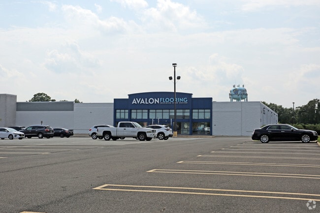
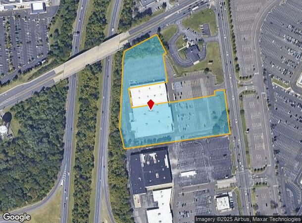
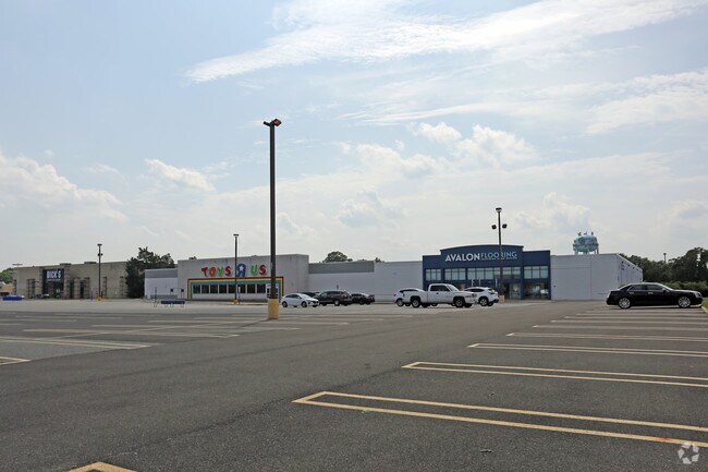
Property Record
1430 Almonesson Rd, Woodbury, NJ 08096

NEARBY LISTINGS FOR SALE OR LEASE
Property Detail
1430 Almonesson Rd
Philadelphia-Camden-Wilmington, PA-NJ-DE-MD
PAR BLK 99 PAR LOT 59 & WESTVILLE RD 8
02-00199-03-00002
Gloucester
Storebuilding
New Jersey
X
2
34015C0103F
5.42 AC
2024
Gloucester County
2025
Philadelphia
501103
DEMOGRAPHICS near 1430 Almonesson Rd
1 Mile
3 Mile
5 Mile
2024 Total Population
6,196
76,894
224,099
2029 Population
6,385
78,268
226,919
Pop Growth 2024-2029
+ 3.05%
+ 1.79%
+ 1.26%
Average Age
44
41
41
2024 Total Households
2,429
31,101
89,094
HH Growth 2024-2029
+ 3.01%
+ 1.72%
+ 1.21%
Median Household Inc
$126,759
$79,871
$83,939
Avg Household Size
2.40
2.40
2.50
2024 Avg HH Vehicles
2.00
2.00
2.00
Median Home Value
$266,375
$214,521
$231,338
Median Year Built
1995
1965
1965
Nearby Places
Map Layers
Map Styles
 Street
 Aerial
- Restaurants
- Banks
- Shops
- Fitness
- Groceries
PUBLIC TRANSPORTATION
COMMUTER RAIL
Lindenwold (Njt) (Atlantic City Line - NJ Transit Commuter Rail (NJ Transit))
DRIVE
WALK
Distance
Lindenwold (Njt) (Atlantic City Line - NJ Transit Commuter Rail (NJ Transit))
12 min
7.1 mi
AIRPORT
Philadelphia International
DRIVE
WALK
Distance
Philadelphia International
27 min
15.7 mi
Freight Ports
Broadway Terminal - Pier 5
DRIVE
WALK
Distance
Broadway Terminal - Pier 5
12 min
7.2 mi
SALE & LEASE HISTORY
LISTING DATE
SALE/LEASE

Mar 07, 2019
For Sale
Jun 03, 2019
For Sale
Nearby Properties
Address
Land Use
TOTAL SIZE
Lot Size
Zoning
Address
Land Use
TOTAL SIZE
Lot Size
Zoning
23.41 AC
BC2
Address
Land Use
TOTAL SIZE
Lot Size
Zoning
1.66 AC
R01
Address
Land Use
TOTAL SIZE
Lot Size
Zoning
30.63 AC
R10
Address
Land Use
TOTAL SIZE
Lot Size
Zoning
40.92 AC
BC2
Address
Land Use
TOTAL SIZE
Lot Size
Zoning
Address
Land Use
TOTAL SIZE
Lot Size
Zoning
49.56 AC
H
Address
Land Use
TOTAL SIZE
Lot Size
Zoning
34.62 AC
Address
Land Use
TOTAL SIZE
Lot Size
Zoning
78.64 AC
Address
Land Use
TOTAL SIZE
Lot Size
Zoning
25.77 AC
R10
Address
Land Use
TOTAL SIZE
Lot Size
Zoning
Address
Land Use
TOTAL SIZE
Lot Size
Zoning
27.25 AC
Address
Land Use
TOTAL SIZE
Lot Size
Zoning
67.33 AC
BC2
Address
Land Use
TOTAL SIZE
Lot Size
Zoning
32.20 AC
R-1
Address
Land Use
TOTAL SIZE
Lot Size
Zoning
21.32 AC
Address
Land Use
TOTAL SIZE
Lot Size
Zoning
63.46 AC
INS
Address
Land Use
TOTAL SIZE
Lot Size
Zoning
29.23 AC
BC3
Address
Land Use
TOTAL SIZE
Lot Size
Zoning
Address
Land Use
TOTAL SIZE
Lot Size
Zoning
15.96 AC
BC2
Address
Land Use
TOTAL SIZE
Lot Size
Zoning
21.16 AC
INS
Address
Land Use
TOTAL SIZE
Lot Size
Zoning
14.49 AC
BC2
Address
Land Use
TOTAL SIZE
Lot Size
Zoning
31.57 AC
RM2
Address
Land Use
TOTAL SIZE
Lot Size
Zoning
3.22 AC
PA
Address
Land Use
TOTAL SIZE
Lot Size
Zoning
8.58 AC
BC2
Address
Land Use
TOTAL SIZE
Lot Size
Zoning
20.85 AC
R-3
Address
Land Use
TOTAL SIZE
Lot Size
Zoning
2.82 AC
BC2
Address
Land Use
TOTAL SIZE
Lot Size
Zoning
3.01 AC
Address
Land Use
TOTAL SIZE
Lot Size
Zoning
14.19 AC
BC2
Address
Land Use
TOTAL SIZE
Lot Size
Zoning
21.81 AC
RM2
Address
Land Use
TOTAL SIZE
Lot Size
Zoning
13.49 AC
BC2
Address
Land Use
TOTAL SIZE
Lot Size
Zoning
The World's #1 Commercial Real Estate Marketplace
Connect with us
© 2025 CoStar Group
The information above has been obtained from sources believed reliable. While we do not doubt its accuracy we have not verified it and make no guarantee, warranty or representation about it. It is your responsibility to independently confirm its accuracy and completeness. Any projections, opinions, assumptions, or estimates used are for example only and do not represent the current or future performance of the property. The value of this transaction to you depends on tax and other factors which should be evaluated by your tax, financial, and legal advisors. You and your advisors should conduct a careful, independent investigation of the property to determine to your satisfaction the suitability of the property for your needs.