Property Record
1430 High St, Williamsburg, VA 23185
This Property Is For Sale
NEARBY LISTINGS FOR SALE OR LEASE
Property Detail
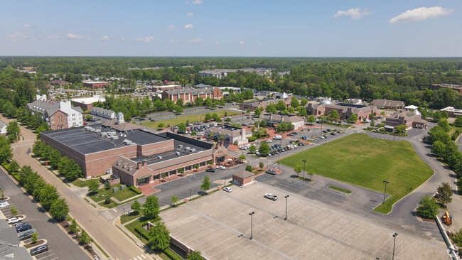
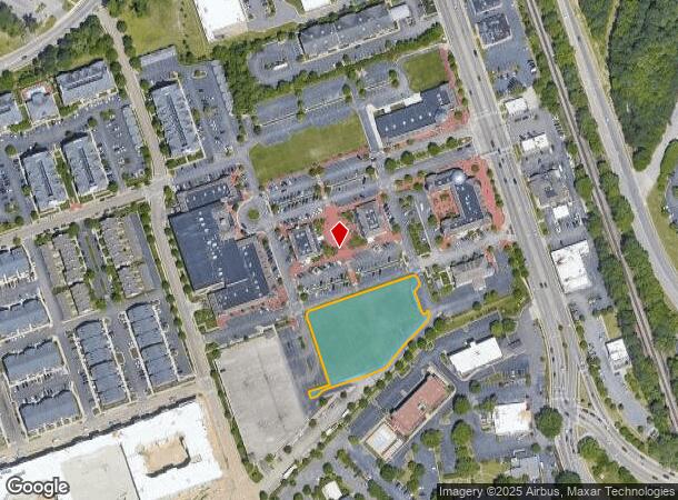
1430 High St
3310.699.196
High Street (Commercial)
Commercialacreage
HIGH STREET CONDOMINIUM UNIT 6
X
Williamsburg
51095C0136D
Virginia
0
Williamsburg/J City Cnty
2024
Hampton Roads
370300
Virginia Beach-Norfolk-Newport News, VA-NC
DEMOGRAPHICS near 1430 High St
1 Mile
3 Mile
5 Mile
2024 Total Population
10,881
43,599
82,833
2029 Population
12,003
47,519
90,136
Pop Growth 2024-2029
+ 10.31%
+ 8.99%
+ 8.82%
Average Age
37
42
43
2024 Total Households
3,583
17,313
33,081
HH Growth 2024-2029
+ 12.67%
+ 9.95%
+ 9.36%
Median Household Inc
$64,084
$78,870
$85,380
Avg Household Size
2.00
2.20
2.30
2024 Avg HH Vehicles
2.00
2.00
2.00
Median Home Value
$290,335
$380,686
$378,069
Median Year Built
1994
1993
1994
Nearby Places
- Restaurants
- Banks
- Shops
- Fitness
- Groceries
PUBLIC TRANSPORTATION
COMMUTER RAIL
Williamsburg Amtrak Station (Northeast Regional - Amtrak)
DRIVE
WALK
Distance
Williamsburg Amtrak Station (Northeast Regional - Amtrak)
6 min
1.6 mi
AIRPORT
Newport News/Williamsburg International
DRIVE
WALK
Distance
Newport News/Williamsburg International
31 min
20.2 mi
Freight Ports
Virginia Port Authority - Newport News
DRIVE
WALK
Distance
Virginia Port Authority - Newport News
44 min
34.2 mi
Nearby Properties
Address
Land Use
TOTAL SIZE
Lot Size
Zoning
Address
Land Use
TOTAL SIZE
Lot Size
Zoning
55,136 SF
348.94 AC
WM (WILLIA
Address
Land Use
TOTAL SIZE
Lot Size
Zoning
100 SF
8,420 AC
RESOURCE C
Address
Land Use
TOTAL SIZE
Lot Size
Zoning
83,748 SF
B-3 (GENER
Address
Land Use
TOTAL SIZE
Lot Size
Zoning
87,083 SF
55.74 AC
WM (WILLIA
Address
Land Use
TOTAL SIZE
Lot Size
Zoning
257 SF
105.86 AC
MU MIXED U
Address
Land Use
TOTAL SIZE
Lot Size
Zoning
88,000 SF
11.48 AC
MS (MUSEUM
Address
Land Use
TOTAL SIZE
Lot Size
Zoning
71,980 SF
6 AC
ED-2 (ECON
Address
Land Use
TOTAL SIZE
Lot Size
Zoning
10,144 SF
87.57 AC
R5 MULTIFA
Address
Land Use
TOTAL SIZE
Lot Size
Zoning
2,317 SF
50.01 AC
R5 MULTIFA
Address
Land Use
TOTAL SIZE
Lot Size
Zoning
52,774 SF
9.07 AC
PLANNED DE
Address
Land Use
TOTAL SIZE
Lot Size
Zoning
263,288 SF
34.22 AC
MU MIXED U
Address
Land Use
TOTAL SIZE
Lot Size
Zoning
625,352 SF
13.60 AC
MU MIXED U
Address
Land Use
TOTAL SIZE
Lot Size
Zoning
109,045 SF
18.31 AC
RS-2 (SING
Address
Land Use
TOTAL SIZE
Lot Size
Zoning
164,647 SF
34.11 AC
MS (MUSEUM
Address
Land Use
TOTAL SIZE
Lot Size
Zoning
491.07 AC
PL PUBLIC
Address
Land Use
TOTAL SIZE
Lot Size
Zoning
182,259 SF
3.60 AC
B-1 (DOWNT
Address
Land Use
TOTAL SIZE
Lot Size
Zoning
49,631 SF
15.58 AC
B1 GENERAL
Address
Land Use
TOTAL SIZE
Lot Size
Zoning
2,387.90 AC
PL PUBLIC
Address
Land Use
TOTAL SIZE
Lot Size
Zoning
501.93 AC
WM (WILLIA
Address
Land Use
TOTAL SIZE
Lot Size
Zoning
3,465 SF
24.94 AC
R5 MULTIFA
Address
Land Use
TOTAL SIZE
Lot Size
Zoning
32,730 SF
4.89 AC
ED-2 (ECON
Address
Land Use
TOTAL SIZE
Lot Size
Zoning
113,000 SF
22.20 AC
WM (WILLIA
Address
Land Use
TOTAL SIZE
Lot Size
Zoning
14,448 SF
6.94 AC
WM (WILLIA
Address
Land Use
TOTAL SIZE
Lot Size
Zoning
2 SF
17.45 AC
R4 RESIDEN
Address
Land Use
TOTAL SIZE
Lot Size
Zoning
167,811 SF
51.70 AC
PUDR PLANN
Address
Land Use
TOTAL SIZE
Lot Size
Zoning
190,936 SF
15.60 AC
R4 RESIDEN
Address
Land Use
TOTAL SIZE
Lot Size
Zoning
36,545 SF
11.48 AC
MS (MUSEUM
Address
Land Use
TOTAL SIZE
Lot Size
Zoning
55,122 SF
11.33 AC
LB-1 (DOWN
Address
Land Use
TOTAL SIZE
Lot Size
Zoning
96,955 SF
4.12 AC
ED-C (ECON
Address
Land Use
TOTAL SIZE
Lot Size
Zoning
60,344 SF
11.41 AC
LB-4 (LIMI
The World's #1 Commercial Real Estate Marketplace
Connect with us
© 2025 CoStar Group
The information above has been obtained from sources believed reliable. While we do not doubt its accuracy we have not verified it and make no guarantee, warranty or representation about it. It is your responsibility to independently confirm its accuracy and completeness. Any projections, opinions, assumptions, or estimates used are for example only and do not represent the current or future performance of the property. The value of this transaction to you depends on tax and other factors which should be evaluated by your tax, financial, and legal advisors. You and your advisors should conduct a careful, independent investigation of the property to determine to your satisfaction the suitability of the property for your needs.