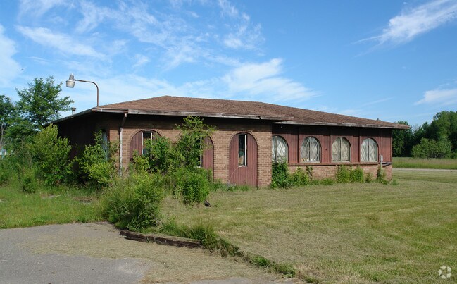
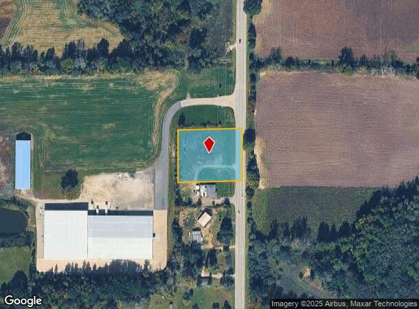
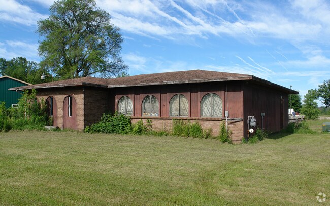
Property Record
1430 S M 13, Lennon, MI 48449
NEARBY LISTINGS FOR SALE OR LEASE
-
-
View all Lennon listings for sale on LoopNet.com
Property Detail
1430 S M 13
008-25-400-017
SEC 25, T7N, R4E N 224 FT OF S 666 FT OF E 264 FT OF NE 14 OF SE 14 1.3 ACRES
Commercialnec
Shiawassee
X
Michigan
26155C0300C
1.30 AC
2025
Midland/Flint
2025
Other Market Areas
030100
Owosso, MI
DEMOGRAPHICS near 1430 S M 13
1 Mile
3 Mile
5 Mile
2024 Total Population
1,194
3,864
14,157
2029 Population
1,181
3,868
13,934
Pop Growth 2024-2029
(1.09%)
+ 0.10%
(1.58%)
Average Age
41
45
44
2024 Total Households
468
1,609
5,798
HH Growth 2024-2029
(1.07%)
+ 0.50%
(1.40%)
Median Household Inc
$44,120
$58,882
$61,210
Avg Household Size
2.50
2.40
2.40
2024 Avg HH Vehicles
2.00
2.00
2.00
Median Home Value
$143,333
$160,141
$164,886
Median Year Built
1980
1971
1970
Nearby Places
Map Layers
Map Styles
 Street
 Aerial
- Restaurants
- Banks
- Shops
- Fitness
- Groceries
PUBLIC TRANSPORTATION
COMMUTER RAIL
Durand Amtrak Station (Blue Water - Amtrak)
DRIVE
WALK
Distance
Durand Amtrak Station (Blue Water - Amtrak)
12 min
6.3 mi
AIRPORT
Bishop International
DRIVE
WALK
Distance
Bishop International
24 min
12.8 mi
Freight Ports
Port of Toledo
DRIVE
WALK
Distance
Port of Toledo
142 min
121.6 mi
Nearby Properties
Address
Land Use
TOTAL SIZE
Lot Size
Zoning
Address
Land Use
TOTAL SIZE
Lot Size
Zoning
Address
Land Use
TOTAL SIZE
Lot Size
Zoning
4,241 SF
107.20 AC
RMH,MOB
Address
Land Use
TOTAL SIZE
Lot Size
Zoning
Address
Land Use
TOTAL SIZE
Lot Size
Zoning
11.10 AC
Address
Land Use
TOTAL SIZE
Lot Size
Zoning
32.90 AC
Address
Land Use
TOTAL SIZE
Lot Size
Zoning
157.53 AC
Address
Land Use
TOTAL SIZE
Lot Size
Zoning
3,278 SF
197.90 AC
RA,AGRI
Address
Land Use
TOTAL SIZE
Lot Size
Zoning
27.60 AC
Address
Land Use
TOTAL SIZE
Lot Size
Zoning
7.70 AC
Address
Land Use
TOTAL SIZE
Lot Size
Zoning
120 AC
Address
Land Use
TOTAL SIZE
Lot Size
Zoning
21,104 SF
7.83 AC
GC,GENE
Address
Land Use
TOTAL SIZE
Lot Size
Zoning
118.44 AC
Address
Land Use
TOTAL SIZE
Lot Size
Zoning
2.40 AC
Address
Land Use
TOTAL SIZE
Lot Size
Zoning
10.10 AC
Address
Land Use
TOTAL SIZE
Lot Size
Zoning
156.80 AC
Address
Land Use
TOTAL SIZE
Lot Size
Zoning
153.65 AC
Address
Land Use
TOTAL SIZE
Lot Size
Zoning
11,336 SF
4.73 AC
LC,LOCA
Address
Land Use
TOTAL SIZE
Lot Size
Zoning
92.10 AC
Address
Land Use
TOTAL SIZE
Lot Size
Zoning
1.90 AC
Address
Land Use
TOTAL SIZE
Lot Size
Zoning
153 AC
Address
Land Use
TOTAL SIZE
Lot Size
Zoning
Address
Land Use
TOTAL SIZE
Lot Size
Zoning
100 AC
Address
Land Use
TOTAL SIZE
Lot Size
Zoning
1,764 SF
40 AC
RA,AGRI
Address
Land Use
TOTAL SIZE
Lot Size
Zoning
119 AC
Address
Land Use
TOTAL SIZE
Lot Size
Zoning
2,128 SF
76 AC
RA,AGRI
Address
Land Use
TOTAL SIZE
Lot Size
Zoning
2,515 SF
70.94 AC
RA,AGRI
Address
Land Use
TOTAL SIZE
Lot Size
Zoning
2,032 SF
89.82 AC
AG-1
Address
Land Use
TOTAL SIZE
Lot Size
Zoning
3,876 SF
76.59 AC
RE,RURA
Address
Land Use
TOTAL SIZE
Lot Size
Zoning
Address
Land Use
TOTAL SIZE
Lot Size
Zoning
116.49 AC
RA,AGRI
The World's #1 Commercial Real Estate Marketplace
Connect with us
© 2025 CoStar Group
The information above has been obtained from sources believed reliable. While we do not doubt its accuracy we have not verified it and make no guarantee, warranty or representation about it. It is your responsibility to independently confirm its accuracy and completeness. Any projections, opinions, assumptions, or estimates used are for example only and do not represent the current or future performance of the property. The value of this transaction to you depends on tax and other factors which should be evaluated by your tax, financial, and legal advisors. You and your advisors should conduct a careful, independent investigation of the property to determine to your satisfaction the suitability of the property for your needs.