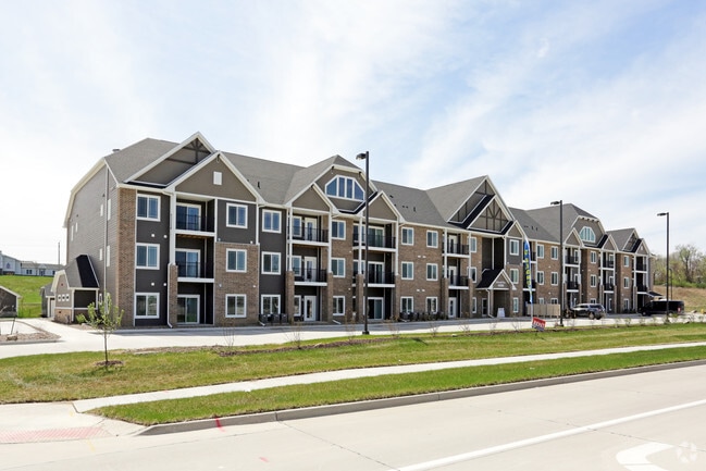
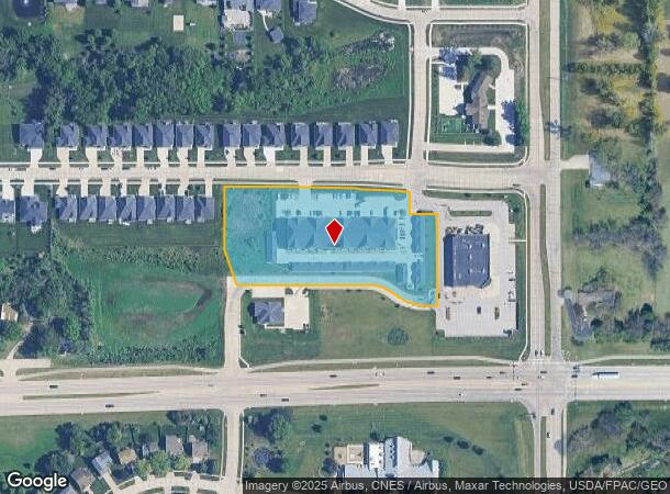
Property Record
14300 Holcomb Ave, Urbandale, IA 50323


NEARBY LISTINGS FOR SALE OR LEASE
-
-
View all Urbandale listings for sale on LoopNet.com
Property Detail
14300 Holcomb Ave
Des Moines-West Des Moines, IA
Reserve Plat 2
12-25-481-002
THE RESERVE PLAT 2 LOT 2
Apartment
Dallas
X
Iowa
19153C0305F
2
2023
3.35 AC
2024
Dallas County
050805
Des Moines
20,572 SF
DEMOGRAPHICS near 14300 Holcomb Ave
1 Mile
3 Mile
5 Mile
2024 Total Population
9,153
67,118
149,211
2029 Population
10,526
79,073
168,606
Pop Growth 2024-2029
+ 15.00%
+ 17.81%
+ 13.00%
Average Age
40
37
38
2024 Total Households
3,224
25,403
60,265
HH Growth 2024-2029
+ 15.20%
+ 18.40%
+ 13.23%
Median Household Inc
$145,291
$107,881
$90,855
Avg Household Size
2.80
2.60
2.40
2024 Avg HH Vehicles
2.00
2.00
2.00
Median Home Value
$384,428
$317,816
$284,971
Median Year Built
2001
2006
2000
Nearby Places
Map Layers
Map Styles
 Street
 Aerial
- Restaurants
- Banks
- Shops
- Fitness
- Groceries
PUBLIC TRANSPORTATION
AIRPORT
Des Moines International
DRIVE
WALK
Distance
Des Moines International
24 min
13.7 mi
Freight Ports
Port Milwaukee
DRIVE
WALK
Distance
Port Milwaukee
426 min
382.7 mi
Nearby Properties
Address
Land Use
TOTAL SIZE
Lot Size
Zoning
Address
Land Use
TOTAL SIZE
Lot Size
Zoning
472,476 SF
12.48 AC
PUD OFFICE
Address
Land Use
TOTAL SIZE
Lot Size
Zoning
18,093 SF
38.92 AC
Address
Land Use
TOTAL SIZE
Lot Size
Zoning
422,683 SF
46.57 AC
PCP
Address
Land Use
TOTAL SIZE
Lot Size
Zoning
457,056 SF
26.01 AC
Address
Land Use
TOTAL SIZE
Lot Size
Zoning
37,325 SF
Address
Land Use
TOTAL SIZE
Lot Size
Zoning
2,864 SF
21.03 AC
Address
Land Use
TOTAL SIZE
Lot Size
Zoning
101,097 SF
30 AC
Address
Land Use
TOTAL SIZE
Lot Size
Zoning
322,220 SF
7.61 AC
Address
Land Use
TOTAL SIZE
Lot Size
Zoning
275,227 SF
18.31 AC
PCP
Address
Land Use
TOTAL SIZE
Lot Size
Zoning
38,400 SF
13.12 AC
Address
Land Use
TOTAL SIZE
Lot Size
Zoning
3,358 SF
21.13 AC
Address
Land Use
TOTAL SIZE
Lot Size
Zoning
196,904 SF
26.10 AC
PUD
Address
Land Use
TOTAL SIZE
Lot Size
Zoning
39,229 SF
22.75 AC
Address
Land Use
TOTAL SIZE
Lot Size
Zoning
22,093 SF
12.26 AC
Address
Land Use
TOTAL SIZE
Lot Size
Zoning
182,866 SF
10.21 AC
Address
Land Use
TOTAL SIZE
Lot Size
Zoning
189,691 SF
27.03 AC
PCP
Address
Land Use
TOTAL SIZE
Lot Size
Zoning
300,000 SF
17.51 AC
Address
Land Use
TOTAL SIZE
Lot Size
Zoning
572,809 SF
42.13 AC
M-2
Address
Land Use
TOTAL SIZE
Lot Size
Zoning
2,168 SF
15.68 AC
Address
Land Use
TOTAL SIZE
Lot Size
Zoning
367,386 SF
24.31 AC
PUD
Address
Land Use
TOTAL SIZE
Lot Size
Zoning
5.75 AC
Address
Land Use
TOTAL SIZE
Lot Size
Zoning
151,344 SF
10.43 AC
C-3
Address
Land Use
TOTAL SIZE
Lot Size
Zoning
39,505 SF
4.94 AC
Address
Land Use
TOTAL SIZE
Lot Size
Zoning
83,370 SF
0.98 AC
C-3
Address
Land Use
TOTAL SIZE
Lot Size
Zoning
79,916 SF
7.82 AC
PUD OFFICE
Address
Land Use
TOTAL SIZE
Lot Size
Zoning
260,000 SF
18.45 AC
Address
Land Use
TOTAL SIZE
Lot Size
Zoning
235,422 SF
13.39 AC
Address
Land Use
TOTAL SIZE
Lot Size
Zoning
80,045 SF
5.07 AC
C-3
Address
Land Use
TOTAL SIZE
Lot Size
Zoning
17.73 AC
The World's #1 Commercial Real Estate Marketplace
Connect with us
© 2025 CoStar Group
The information above has been obtained from sources believed reliable. While we do not doubt its accuracy we have not verified it and make no guarantee, warranty or representation about it. It is your responsibility to independently confirm its accuracy and completeness. Any projections, opinions, assumptions, or estimates used are for example only and do not represent the current or future performance of the property. The value of this transaction to you depends on tax and other factors which should be evaluated by your tax, financial, and legal advisors. You and your advisors should conduct a careful, independent investigation of the property to determine to your satisfaction the suitability of the property for your needs.