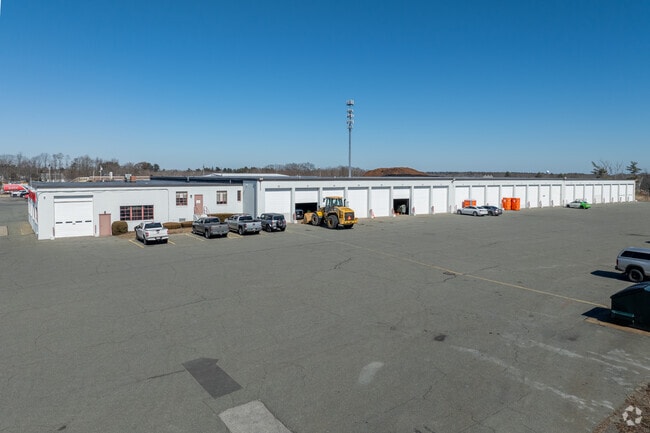
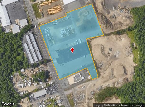
Property Record
1431 Bedford St, Abington, MA 02351

Current Lease Availabilities
NEARBY LISTINGS FOR SALE OR LEASE
Property Detail
1431 Bedford St
ABIN-000068-000000-000024
Plymouth
Truckterminal
Massachusetts
X
24
25021C0239F
9.51 AC
2025
Route 24
2025
Boston
520201
Boston-Cambridge-Newton, MA-NH
58,793 SF
DEMOGRAPHICS near 1431 Bedford St
1 Mile
3 Mile
5 Mile
2024 Total Population
6,191
51,226
167,298
2029 Population
6,236
51,178
166,778
Pop Growth 2024-2029
+ 0.73%
(0.09%)
(0.31%)
Average Age
41
42
41
2024 Total Households
2,527
20,539
63,109
HH Growth 2024-2029
+ 0.40%
(0.13%)
(0.36%)
Median Household Inc
$121,838
$105,829
$99,260
Avg Household Size
2.40
2.40
2.60
2024 Avg HH Vehicles
2.00
2.00
2.00
Median Home Value
$528,571
$464,894
$448,952
Median Year Built
1974
1965
1963
Nearby Places
Map Layers
Map Styles
 Street
 Aerial
- Restaurants
- Banks
- Shops
- Fitness
- Groceries
PUBLIC TRANSPORTATION
COMMUTER RAIL
South Weymouth (Kingston/Plymouth Line - Massachusetts Bay Transportation Authority Commuter Rail (Purple Line))
DRIVE
WALK
Distance
South Weymouth (Kingston/Plymouth Line - Massachusetts Bay Transportation Authority Commuter Rail (Purple Line))
2 min
20 min
1.1 mi
Abington (Kingston/Plymouth Line - Massachusetts Bay Transportation Authority Commuter Rail (Purple Line))
DRIVE
WALK
Distance
Abington (Kingston/Plymouth Line - Massachusetts Bay Transportation Authority Commuter Rail (Purple Line))
6 min
3.0 mi
AIRPORT
General Edward Lawrence Logan International
DRIVE
WALK
Distance
General Edward Lawrence Logan International
33 min
21.2 mi
Freight Ports
Port of Boston
DRIVE
WALK
Distance
Port of Boston
30 min
19.0 mi
Nearby Properties
Address
Land Use
TOTAL SIZE
Lot Size
Zoning
Address
Land Use
TOTAL SIZE
Lot Size
Zoning
31.29 AC
100
Address
Land Use
TOTAL SIZE
Lot Size
Zoning
40,396 SF
5.56 AC
100
Address
Land Use
TOTAL SIZE
Lot Size
Zoning
Address
Land Use
TOTAL SIZE
Lot Size
Zoning
235,150 SF
36.67 AC
R1
Address
Land Use
TOTAL SIZE
Lot Size
Zoning
32.04 AC
Address
Land Use
TOTAL SIZE
Lot Size
Zoning
3.65 AC
100
Address
Land Use
TOTAL SIZE
Lot Size
Zoning
168,801 SF
2.75 AC
100
Address
Land Use
TOTAL SIZE
Lot Size
Zoning
0.42 AC
A1
Address
Land Use
TOTAL SIZE
Lot Size
Zoning
36.20 AC
Address
Land Use
TOTAL SIZE
Lot Size
Zoning
144,377 SF
9.39 AC
Address
Land Use
TOTAL SIZE
Lot Size
Zoning
170,035 SF
1.64 AC
100
Address
Land Use
TOTAL SIZE
Lot Size
Zoning
147,069 SF
1.90 AC
Address
Land Use
TOTAL SIZE
Lot Size
Zoning
3.92 AC
R-4
Address
Land Use
TOTAL SIZE
Lot Size
Zoning
8.54 AC
100
Address
Land Use
TOTAL SIZE
Lot Size
Zoning
35.10 AC
Address
Land Use
TOTAL SIZE
Lot Size
Zoning
34.28 AC
85
Address
Land Use
TOTAL SIZE
Lot Size
Zoning
3.72 AC
INDUST
Address
Land Use
TOTAL SIZE
Lot Size
Zoning
74,600 SF
6.29 AC
Address
Land Use
TOTAL SIZE
Lot Size
Zoning
85,338 SF
1.85 AC
Address
Land Use
TOTAL SIZE
Lot Size
Zoning
10.83 AC
Address
Land Use
TOTAL SIZE
Lot Size
Zoning
162,931 SF
4.50 AC
INDUST
Address
Land Use
TOTAL SIZE
Lot Size
Zoning
14.52 AC
Address
Land Use
TOTAL SIZE
Lot Size
Zoning
73,460 SF
1.16 AC
A2
Address
Land Use
TOTAL SIZE
Lot Size
Zoning
60,832 SF
1.89 AC
Address
Land Use
TOTAL SIZE
Lot Size
Zoning
60,832 SF
2.28 AC
Address
Land Use
TOTAL SIZE
Lot Size
Zoning
43.35 AC
Address
Land Use
TOTAL SIZE
Lot Size
Zoning
89,764 SF
6.77 AC
Address
Land Use
TOTAL SIZE
Lot Size
Zoning
94,940 SF
16.96 AC
INDUST
Address
Land Use
TOTAL SIZE
Lot Size
Zoning
2.64 AC
100
Address
Land Use
TOTAL SIZE
Lot Size
Zoning
88,903 SF
8.25 AC
The World's #1 Commercial Real Estate Marketplace
Connect with us
© 2026 CoStar Group
The information above has been obtained from sources believed reliable. While we do not doubt its accuracy we have not verified it and make no guarantee, warranty or representation about it. It is your responsibility to independently confirm its accuracy and completeness. Any projections, opinions, assumptions, or estimates used are for example only and do not represent the current or future performance of the property. The value of this transaction to you depends on tax and other factors which should be evaluated by your tax, financial, and legal advisors. You and your advisors should conduct a careful, independent investigation of the property to determine to your satisfaction the suitability of the property for your needs.