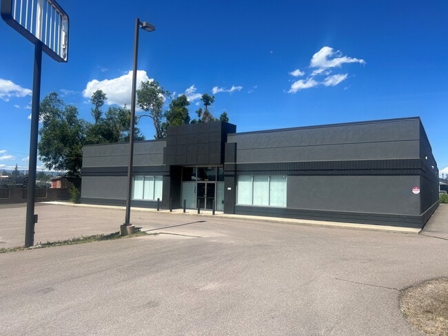
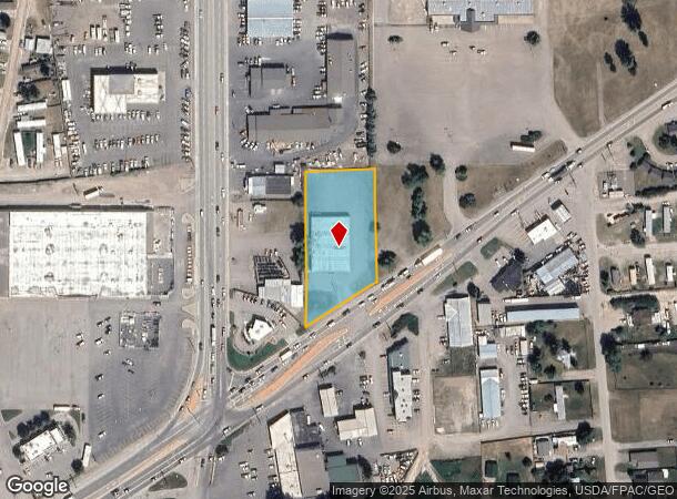
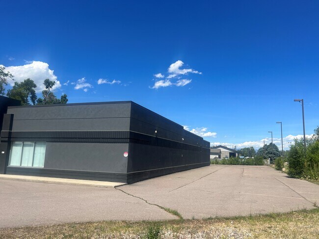
Property Record
1431 Mt Highway 35, Kalispell, MT 59901
NEARBY LISTINGS FOR SALE OR LEASE
Property Detail
1431 Mt Highway 35
07-3966-04-4-05-65-0000
Certificate Of Survey No 14367
Officebuilding
S04, T28 N, R21 W, C.O.S. 14367-A, TR 4UAA,TR 4UAB IN SE4
AE
Flathead
30029C1810J
Montana
2025
1.15 AC
2025
Glacier Country
000700
Other Market Areas
11,782 SF
Kalispell, MT
DEMOGRAPHICS near 1431 Mt Highway 35
1 Mile
3 Mile
5 Mile
2024 Total Population
3,989
33,630
50,942
2029 Population
4,701
39,702
60,130
Pop Growth 2024-2029
+ 17.85%
+ 18.06%
+ 18.04%
Average Age
40
41
40
2024 Total Households
1,592
14,060
20,500
HH Growth 2024-2029
+ 17.59%
+ 17.96%
+ 17.94%
Median Household Inc
$64,951
$61,714
$65,690
Avg Household Size
2.40
2.30
2.40
2024 Avg HH Vehicles
2.00
2.00
2.00
Median Home Value
$216,161
$339,337
$363,157
Median Year Built
1979
1983
1991
Nearby Places
Map Layers
Map Styles
 Street
 Aerial
- Restaurants
- Banks
- Shops
- Fitness
- Groceries
PUBLIC TRANSPORTATION
AIRPORT
Glacier Park International
DRIVE
WALK
Distance
Glacier Park International
12 min
7.0 mi
Freight Ports
Port of Everett
DRIVE
WALK
Distance
Port of Everett
630 min
546.9 mi
SALE & LEASE HISTORY
LISTING DATE
SALE/LEASE

Oct 14, 2024
For Sale
Apr 16, 2021
For Lease
Nearby Properties
Address
Land Use
TOTAL SIZE
Lot Size
Zoning
Address
Land Use
TOTAL SIZE
Lot Size
Zoning
800,000 SF
9.86 AC
5
Address
Land Use
TOTAL SIZE
Lot Size
Zoning
85,209 SF
3.32 AC
Address
Land Use
TOTAL SIZE
Lot Size
Zoning
321,200 SF
7.77 AC
Address
Land Use
TOTAL SIZE
Lot Size
Zoning
57,624 SF
3.73 AC
Address
Land Use
TOTAL SIZE
Lot Size
Zoning
58,248 SF
11.94 AC
5
Address
Land Use
TOTAL SIZE
Lot Size
Zoning
105,300 SF
2.56 AC
Address
Land Use
TOTAL SIZE
Lot Size
Zoning
117,819 SF
3.70 AC
Address
Land Use
TOTAL SIZE
Lot Size
Zoning
188,028 SF
17.70 AC
Address
Land Use
TOTAL SIZE
Lot Size
Zoning
33,084 SF
5.42 AC
Address
Land Use
TOTAL SIZE
Lot Size
Zoning
97,968 SF
6.31 AC
Address
Land Use
TOTAL SIZE
Lot Size
Zoning
79,844 SF
3.21 AC
Address
Land Use
TOTAL SIZE
Lot Size
Zoning
84,996 SF
3.18 AC
Address
Land Use
TOTAL SIZE
Lot Size
Zoning
45,000 SF
6.79 AC
Address
Land Use
TOTAL SIZE
Lot Size
Zoning
231,514 SF
22.45 AC
6
Address
Land Use
TOTAL SIZE
Lot Size
Zoning
62,420 SF
1.73 AC
Address
Land Use
TOTAL SIZE
Lot Size
Zoning
115,524 SF
13.03 AC
Address
Land Use
TOTAL SIZE
Lot Size
Zoning
125,344 SF
10.06 AC
Address
Land Use
TOTAL SIZE
Lot Size
Zoning
139,724 SF
0.08 AC
Address
Land Use
TOTAL SIZE
Lot Size
Zoning
25,848 SF
2.61 AC
Address
Land Use
TOTAL SIZE
Lot Size
Zoning
83,823 SF
4.78 AC
Address
Land Use
TOTAL SIZE
Lot Size
Zoning
31,230 SF
0.64 AC
Address
Land Use
TOTAL SIZE
Lot Size
Zoning
59,195 SF
5 AC
Address
Land Use
TOTAL SIZE
Lot Size
Zoning
32,769 SF
Address
Land Use
TOTAL SIZE
Lot Size
Zoning
78,433 SF
7.64 AC
Address
Land Use
TOTAL SIZE
Lot Size
Zoning
57,840 SF
30.18 AC
Address
Land Use
TOTAL SIZE
Lot Size
Zoning
15,856 SF
3.64 AC
6
Address
Land Use
TOTAL SIZE
Lot Size
Zoning
69,429 SF
5.97 AC
Address
Land Use
TOTAL SIZE
Lot Size
Zoning
34,284 SF
7.37 AC
6
Address
Land Use
TOTAL SIZE
Lot Size
Zoning
34,780 SF
13.03 AC
Address
Land Use
TOTAL SIZE
Lot Size
Zoning
45,000 SF
17.54 AC
The World's #1 Commercial Real Estate Marketplace
Connect with us
© 2025 CoStar Group
The information above has been obtained from sources believed reliable. While we do not doubt its accuracy we have not verified it and make no guarantee, warranty or representation about it. It is your responsibility to independently confirm its accuracy and completeness. Any projections, opinions, assumptions, or estimates used are for example only and do not represent the current or future performance of the property. The value of this transaction to you depends on tax and other factors which should be evaluated by your tax, financial, and legal advisors. You and your advisors should conduct a careful, independent investigation of the property to determine to your satisfaction the suitability of the property for your needs.