Property Record
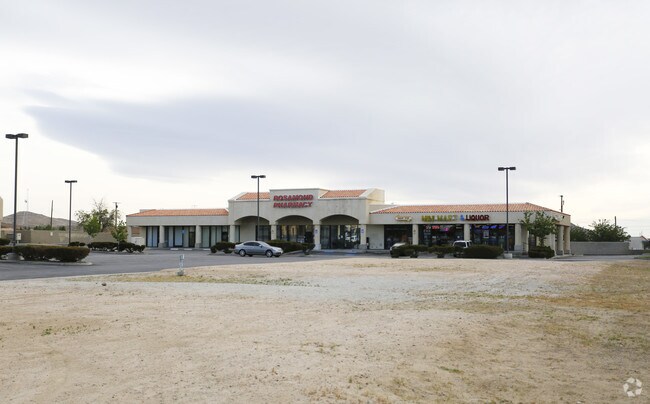
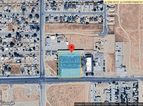
1431 W Rosamond Blvd, Rosamond, CA 93560
NEARBY LISTINGS FOR SALE OR LEASE
Property Detail
1431 W Rosamond Blvd
Bakersfield, CA
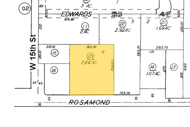
Parcel Map No . 3090
251-030-23-00-6
PARCEL MAP 3090 , LOT 4
Regionalshoppingcenterormallwithanchorstore
Kern
X
California
06029C4025E
4
2024
2.44 AC
2025
SE Outlying Kern County
005804
Bakersfield
21,000 SF
DEMOGRAPHICS near 1431 W Rosamond Blvd
1 Mile
3 Mile
5 Mile
2024 Total Population
8,403
18,899
20,610
2029 Population
8,461
19,037
20,761
Pop Growth 2024-2029
+ 0.69%
+ 0.73%
+ 0.73%
Average Age
34
35
35
2024 Total Households
2,839
6,370
6,971
HH Growth 2024-2029
+ 0.49%
+ 0.60%
+ 0.60%
Median Household Inc
$53,276
$70,277
$70,302
Avg Household Size
2.80
2.90
2.90
2024 Avg HH Vehicles
2.00
2.00
2.00
Median Home Value
$259,821
$285,561
$280,793
Median Year Built
1988
1993
1993
Nearby Places
Map Layers
Map Styles
 Street
 Aerial
- Restaurants
- Banks
- Shops
- Fitness
- Groceries
SALE & LEASE HISTORY
LISTING DATE
SALE/LEASE

Apr 27, 2017
For Lease
Nearby Properties
Address
Land Use
TOTAL SIZE
Lot Size
Zoning
Address
Land Use
TOTAL SIZE
Lot Size
Zoning
59,719 SF
7.33 AC
R-1
Address
Land Use
TOTAL SIZE
Lot Size
Zoning
87,633 SF
7.50 AC
R-2
Address
Land Use
TOTAL SIZE
Lot Size
Zoning
78,737 SF
2.73 AC
C2
Address
Land Use
TOTAL SIZE
Lot Size
Zoning
17,253 SF
2.91 AC
C2
Address
Land Use
TOTAL SIZE
Lot Size
Zoning
11,575 SF
4.16 AC
R3
Address
Land Use
TOTAL SIZE
Lot Size
Zoning
Address
Land Use
TOTAL SIZE
Lot Size
Zoning
47,337 SF
3.65 AC
C2
Address
Land Use
TOTAL SIZE
Lot Size
Zoning
12,240 SF
5.30 AC
M-2
Address
Land Use
TOTAL SIZE
Lot Size
Zoning
Address
Land Use
TOTAL SIZE
Lot Size
Zoning
19,519 SF
9.32 AC
M-3
Address
Land Use
TOTAL SIZE
Lot Size
Zoning
22,352 SF
8.64 AC
M-3
Address
Land Use
TOTAL SIZE
Lot Size
Zoning
4,951 SF
1.49 AC
C1
Address
Land Use
TOTAL SIZE
Lot Size
Zoning
Address
Land Use
TOTAL SIZE
Lot Size
Zoning
31,608 SF
2.72 AC
R-1
Address
Land Use
TOTAL SIZE
Lot Size
Zoning
9,209 SF
1.80 AC
C2 PD FPS
Address
Land Use
TOTAL SIZE
Lot Size
Zoning
27,340 SF
1.54 AC
R-3 PD
Address
Land Use
TOTAL SIZE
Lot Size
Zoning
27,340 SF
1.54 AC
R-3 PD
Address
Land Use
TOTAL SIZE
Lot Size
Zoning
9,350 SF
0.73 AC
R-3
Address
Land Use
TOTAL SIZE
Lot Size
Zoning
2,400 SF
0.82 AC
M-1
Address
Land Use
TOTAL SIZE
Lot Size
Zoning
Address
Land Use
TOTAL SIZE
Lot Size
Zoning
1,120 SF
6.17 AC
M2
Address
Land Use
TOTAL SIZE
Lot Size
Zoning
1,913 SF
0.96 AC
C-2 PD
Address
Land Use
TOTAL SIZE
Lot Size
Zoning
9,100 SF
1.02 AC
C-2
Address
Land Use
TOTAL SIZE
Lot Size
Zoning
4,530 SF
0.84 AC
C2
Address
Land Use
TOTAL SIZE
Lot Size
Zoning
1,842 SF
2.55 AC
R-3 PD FPS
Address
Land Use
TOTAL SIZE
Lot Size
Zoning
4.27 AC
R-3 PD
Address
Land Use
TOTAL SIZE
Lot Size
Zoning
5.58 AC
R-1
Address
Land Use
TOTAL SIZE
Lot Size
Zoning
28.93 AC
M-2
Address
Land Use
TOTAL SIZE
Lot Size
Zoning
7,378 SF
0.66 AC
C-2
The World's #1 Commercial Real Estate Marketplace
Connect with us
© 2026 CoStar Group
The information above has been obtained from sources believed reliable. While we do not doubt its accuracy we have not verified it and make no guarantee, warranty or representation about it. It is your responsibility to independently confirm its accuracy and completeness. Any projections, opinions, assumptions, or estimates used are for example only and do not represent the current or future performance of the property. The value of this transaction to you depends on tax and other factors which should be evaluated by your tax, financial, and legal advisors. You and your advisors should conduct a careful, independent investigation of the property to determine to your satisfaction the suitability of the property for your needs.