Property Record
14321 Route 1 Hwy, Chester, VA 23831
NEARBY LISTINGS FOR SALE OR LEASE
-
-
-
-
No Photo
-
-
-
-
View all Chester listings for sale on LoopNet.com
Property Detail
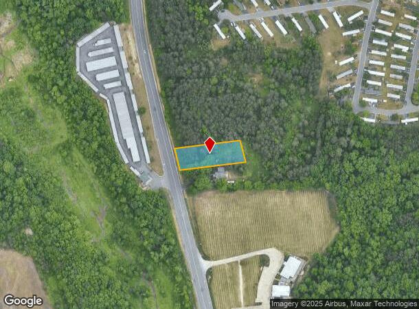
14321 Route 1 Hwy
Richmond, VA
Route 1
800-64-59-20-100-000
ROUTE 1
Commercialnec
Chesterfield
X
Virginia
51041C0334E
0.69 AC
2025
Iron Bridge Corridor
2025
Richmond VA
100506
DEMOGRAPHICS near 14321 Route 1 Hwy
1 Mile
3 Mile
5 Mile
2024 Total Population
6,701
36,277
86,038
2029 Population
7,286
39,566
92,891
Pop Growth 2024-2029
+ 8.73%
+ 9.07%
+ 7.97%
Average Age
37
39
41
2024 Total Households
2,239
13,568
31,527
HH Growth 2024-2029
+ 8.80%
+ 9.22%
+ 8.38%
Median Household Inc
$91,309
$78,289
$79,363
Avg Household Size
2.90
2.60
2.60
2024 Avg HH Vehicles
2.00
2.00
2.00
Median Home Value
$277,030
$276,108
$272,767
Median Year Built
1995
1990
1990
Nearby Places
Map Layers
Map Styles
 Street
 Aerial
- Restaurants
- Banks
- Shops
- Fitness
- Groceries
PUBLIC TRANSPORTATION
COMMUTER RAIL
Petersburg Amtrak Station (Carolinian - Amtrak, Northeast Regional - Amtrak, Palmetto - Amtrak, Silver Meteor - Amtrak, Silver Star - Amtrak)
DRIVE
WALK
Distance
Petersburg Amtrak Station (Carolinian - Amtrak, Northeast Regional - Amtrak, Palmetto - Amtrak, Silver Meteor - Amtrak, Silver Star - Amtrak)
12 min
7.1 mi
AIRPORT
Richmond International
DRIVE
WALK
Distance
Richmond International
31 min
20.3 mi
Freight Ports
Virginia Port Authority - Richmond
DRIVE
WALK
Distance
Virginia Port Authority - Richmond
19 min
12.6 mi
Nearby Properties
Address
Land Use
TOTAL SIZE
Lot Size
Zoning
Address
Land Use
TOTAL SIZE
Lot Size
Zoning
440,100 SF
82.70 AC
I2 - GEN I
Address
Land Use
TOTAL SIZE
Lot Size
Zoning
505,068 SF
60.92 AC
I2 - GEN I
Address
Land Use
TOTAL SIZE
Lot Size
Zoning
806,770 SF
129.28 AC
I2 - GEN I
Address
Land Use
TOTAL SIZE
Lot Size
Zoning
32,947 SF
13.38 AC
C5 - GEN B
Address
Land Use
TOTAL SIZE
Lot Size
Zoning
289,964 SF
39.62 AC
R7 - SINGL
Address
Land Use
TOTAL SIZE
Lot Size
Zoning
1.60 AC
RMF - RES,
Address
Land Use
TOTAL SIZE
Lot Size
Zoning
100 SF
36.88 AC
RMF - RES,
Address
Land Use
TOTAL SIZE
Lot Size
Zoning
177,908 SF
13.59 AC
RMF - RES,
Address
Land Use
TOTAL SIZE
Lot Size
Zoning
89,260 SF
47.75 AC
I2 - GEN I
Address
Land Use
TOTAL SIZE
Lot Size
Zoning
116,527 SF
25.57 AC
RMF - RES,
Address
Land Use
TOTAL SIZE
Lot Size
Zoning
157,534 SF
39.59 AC
R7 - SINGL
Address
Land Use
TOTAL SIZE
Lot Size
Zoning
482,476 SF
19.75 AC
I2 - GEN I
Address
Land Use
TOTAL SIZE
Lot Size
Zoning
100 SF
25.80 AC
R7 - SINGL
Address
Land Use
TOTAL SIZE
Lot Size
Zoning
296,000 SF
42.39 AC
I2 - GEN I
Address
Land Use
TOTAL SIZE
Lot Size
Zoning
241,800 SF
16.96 AC
I2 - GEN I
Address
Land Use
TOTAL SIZE
Lot Size
Zoning
752 SF
28.91 AC
R7 - SINGL
Address
Land Use
TOTAL SIZE
Lot Size
Zoning
287,313 SF
17.26 AC
I1 - LT IN
Address
Land Use
TOTAL SIZE
Lot Size
Zoning
261,922 SF
19.85 AC
I1 - LT IN
Address
Land Use
TOTAL SIZE
Lot Size
Zoning
3,946 SF
17.72 AC
R15 - SING
Address
Land Use
TOTAL SIZE
Lot Size
Zoning
260,928 SF
19.40 AC
I1 - LT IN
Address
Land Use
TOTAL SIZE
Lot Size
Zoning
194,000 SF
175.55 AC
I1 - LT IN
Address
Land Use
TOTAL SIZE
Lot Size
Zoning
187,980 SF
15.31 AC
I1 - LT IN
Address
Land Use
TOTAL SIZE
Lot Size
Zoning
173,800 SF
15.99 AC
I2 - GEN I
Address
Land Use
TOTAL SIZE
Lot Size
Zoning
69,048 SF
16 AC
R7 - SINGL
Address
Land Use
TOTAL SIZE
Lot Size
Zoning
29,808 SF
5.63 AC
C3 - COMMU
Address
Land Use
TOTAL SIZE
Lot Size
Zoning
86,109 SF
29.94 AC
C3 - COMMU
Address
Land Use
TOTAL SIZE
Lot Size
Zoning
490,345 SF
101.57 AC
I2 - GEN I
Address
Land Use
TOTAL SIZE
Lot Size
Zoning
92,905 SF
49.45 AC
A - AGRICU
Address
Land Use
TOTAL SIZE
Lot Size
Zoning
132,121 SF
61.15 AC
I2 - GEN I
Address
Land Use
TOTAL SIZE
Lot Size
Zoning
147,276 SF
27.04 AC
R7 - SINGL
The World's #1 Commercial Real Estate Marketplace
Connect with us
© 2025 CoStar Group
The information above has been obtained from sources believed reliable. While we do not doubt its accuracy we have not verified it and make no guarantee, warranty or representation about it. It is your responsibility to independently confirm its accuracy and completeness. Any projections, opinions, assumptions, or estimates used are for example only and do not represent the current or future performance of the property. The value of this transaction to you depends on tax and other factors which should be evaluated by your tax, financial, and legal advisors. You and your advisors should conduct a careful, independent investigation of the property to determine to your satisfaction the suitability of the property for your needs.