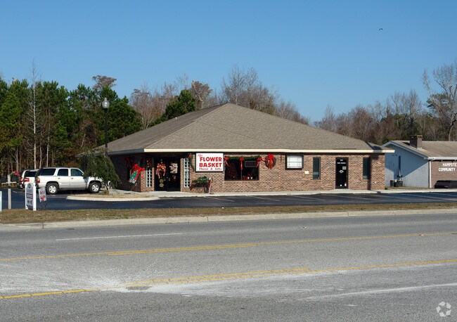
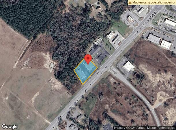
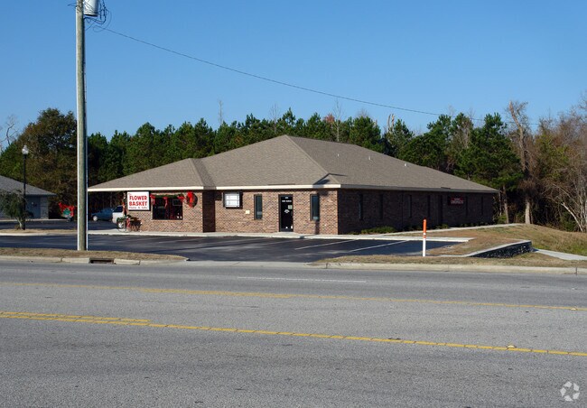
Property Record
14341 Us Highway 17, Hampstead, NC 28443
NEARBY LISTINGS FOR SALE OR LEASE
-
-
View all Hampstead listings for sale on LoopNet.com
Property Detail
14341 Us Highway 17
3282-76-8068-0000
ON N/W SIDE 17 S/HAMPSTEAD
Storebuilding
Pender
X
North Carolina
3720328200J
0.95 AC
2024
East Pender County
2024
Wilmington
920201
Wilmington, NC
9,253 SF
DEMOGRAPHICS near 14341 Us Highway 17
1 Mile
3 Mile
5 Mile
2024 Total Population
2,171
10,749
20,415
2029 Population
2,661
13,124
24,779
Pop Growth 2024-2029
+ 22.57%
+ 22.10%
+ 21.38%
Average Age
40
41
42
2024 Total Households
802
4,064
7,864
HH Growth 2024-2029
+ 22.82%
+ 22.37%
+ 21.52%
Median Household Inc
$107,049
$103,181
$94,200
Avg Household Size
2.70
2.60
2.60
2024 Avg HH Vehicles
2.00
2.00
2.00
Median Home Value
$333,181
$334,384
$329,537
Median Year Built
2005
2003
2002
Nearby Places
Map Layers
Map Styles
 Street
 Aerial
- Restaurants
- Banks
- Shops
- Fitness
- Groceries
PUBLIC TRANSPORTATION
AIRPORT
Wilmington International
DRIVE
WALK
Distance
Wilmington International
29 min
18.3 mi
Albert J Ellis
DRIVE
WALK
Distance
Albert J Ellis
70 min
46.3 mi
Freight Ports
Port of Wilmington
DRIVE
WALK
Distance
Port of Wilmington
36 min
25.9 mi
Nearby Properties
Address
Land Use
TOTAL SIZE
Lot Size
Zoning
Address
Land Use
TOTAL SIZE
Lot Size
Zoning
251,100 SF
18 AC
SEEMAP
Address
Land Use
TOTAL SIZE
Lot Size
Zoning
90,501 SF
7.03 AC
GB
Address
Land Use
TOTAL SIZE
Lot Size
Zoning
52,259 SF
11.40 AC
R20
Address
Land Use
TOTAL SIZE
Lot Size
Zoning
62,793 SF
24.19 AC
PD
Address
Land Use
TOTAL SIZE
Lot Size
Zoning
63,886 SF
11.51 AC
PD
Address
Land Use
TOTAL SIZE
Lot Size
Zoning
2,921.99 AC
SEEMAP
Address
Land Use
TOTAL SIZE
Lot Size
Zoning
21,831 SF
9.76 AC
SEEMAP
Address
Land Use
TOTAL SIZE
Lot Size
Zoning
45,636 SF
6.45 AC
GB
Address
Land Use
TOTAL SIZE
Lot Size
Zoning
24,000 SF
2.79 AC
B2
Address
Land Use
TOTAL SIZE
Lot Size
Zoning
11,828 SF
1.66 AC
Address
Land Use
TOTAL SIZE
Lot Size
Zoning
1,324.37 AC
RA
Address
Land Use
TOTAL SIZE
Lot Size
Zoning
41.76 AC
GB
Address
Land Use
TOTAL SIZE
Lot Size
Zoning
16,748 SF
6.26 AC
SEEMAP
Address
Land Use
TOTAL SIZE
Lot Size
Zoning
12,820 SF
2.30 AC
SEEMAP
Address
Land Use
TOTAL SIZE
Lot Size
Zoning
Address
Land Use
TOTAL SIZE
Lot Size
Zoning
15,202 SF
1.16 AC
Address
Land Use
TOTAL SIZE
Lot Size
Zoning
13,220 SF
1.50 AC
SEEMAP
Address
Land Use
TOTAL SIZE
Lot Size
Zoning
15,000 SF
2.24 AC
B2
Address
Land Use
TOTAL SIZE
Lot Size
Zoning
8,970 SF
3.21 AC
SEEMAP
Address
Land Use
TOTAL SIZE
Lot Size
Zoning
7,941 SF
152.72 AC
PD
Address
Land Use
TOTAL SIZE
Lot Size
Zoning
23,565 SF
3.15 AC
B2
Address
Land Use
TOTAL SIZE
Lot Size
Zoning
25,000 SF
1.96 AC
SEEMAP
Address
Land Use
TOTAL SIZE
Lot Size
Zoning
12,772 SF
1.13 AC
GB
Address
Land Use
TOTAL SIZE
Lot Size
Zoning
6,621 SF
2.43 AC
GB
Address
Land Use
TOTAL SIZE
Lot Size
Zoning
3,038 SF
6.81 AC
SEEMAP
Address
Land Use
TOTAL SIZE
Lot Size
Zoning
11,852 SF
0.45 AC
B2
Address
Land Use
TOTAL SIZE
Lot Size
Zoning
0.26 AC
Address
Land Use
TOTAL SIZE
Lot Size
Zoning
22,000 SF
2.34 AC
B2
Address
Land Use
TOTAL SIZE
Lot Size
Zoning
13,226 SF
3.02 AC
SEEMAP
The World's #1 Commercial Real Estate Marketplace
Connect with us
© 2026 CoStar Group
The information above has been obtained from sources believed reliable. While we do not doubt its accuracy we have not verified it and make no guarantee, warranty or representation about it. It is your responsibility to independently confirm its accuracy and completeness. Any projections, opinions, assumptions, or estimates used are for example only and do not represent the current or future performance of the property. The value of this transaction to you depends on tax and other factors which should be evaluated by your tax, financial, and legal advisors. You and your advisors should conduct a careful, independent investigation of the property to determine to your satisfaction the suitability of the property for your needs.