Property Record
14348 Blue Marlin Rd, Placida, FL 33946
Property Detail
14348 Blue Marlin Rd
Punta Gorda, FL
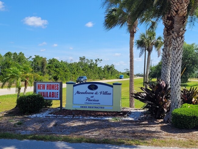
ROTONDA VILLAS BLK30 LT 256 894/685 2416/110 3134/583
422104452010
CHARLOTTE
Residentialacreage
Florida
RSF5
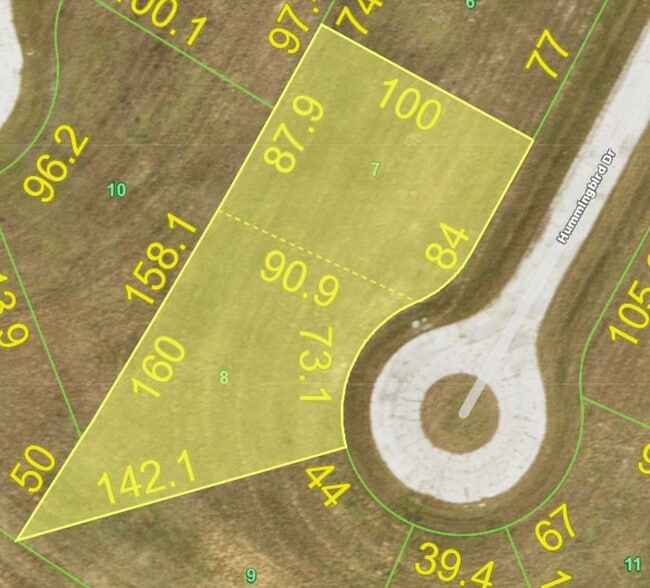
256
AE The base floodplain where base flood elevations are provided. AE Zones are now used on new format FIRMs instead of A1-A30 Zones.
0.36 AC
2024
Charlotte County
2025
Southwest Florida
030504
NEARBY LISTINGS FOR SALE OR LEASE
-
-
View all Placida listings for sale on LoopNet.com
DEMOGRAPHICS near 14348 Blue Marlin Rd
1 mile
3 mile
5 mile
2025 Total Population
1,527
11,167
31,017
2030 Population
1,809
12,674
34,656
Pop Growth 2025-2030
+ 18.47%
+ 13.50%
+ 11.73%
Average Age
61
59
58
2025 Total Households
761
5,205
14,834
HH Growth 2025-2030
+ 18.53%
+ 13.43%
+ 11.62%
Median Household Inc
$93,848
$95,940
$82,937
Avg Household Size
2.00
2.10
2.10
2025 Avg HH Vehicles
2.00
2.00
2.00
Median Home Value
$531,077
$491,383
$436,043
Median Year Built
2010
2008
2000
Nearby Places
Map Layers
Map Styles
 Street
 Aerial
Layers
 Traffic
 Biking
Places
Listings with unknown addresses are not visible on the map
- Restaurants
- Banks
- Shops
- Fitness
- Groceries
PUBLIC TRANSPORTATION
AIRPORT
Punta Gorda
Drive
Walk
Distance
Punta Gorda
54 min
28.2 mi
Freight Ports
Port Manatee
Drive
Walk
Distance
Port Manatee
104 min
70.1 mi
SALE & LEASE HISTORY
LISTING DATE
SALE/LEASE

May 28, 2024
For Sale
Nearby Properties
Address
Land Use
TOTAL SIZE
Lot Size
Zoning
Address
Land Use
TOTAL SIZE
Lot Size
Zoning
42,935 SF
167.66 AC
RE1
Address
Land Use
TOTAL SIZE
Lot Size
Zoning
1,200 SF
29.50 AC
CG
Address
Land Use
TOTAL SIZE
Lot Size
Zoning
4,326 SF
31.99 AC
MHP
Address
Land Use
TOTAL SIZE
Lot Size
Zoning
2,940 SF
332.40 AC
RSF5
Address
Land Use
TOTAL SIZE
Lot Size
Zoning
20,650 SF
1.61 AC
CG
Address
Land Use
TOTAL SIZE
Lot Size
Zoning
1,430 SF
5.98 AC
CG
Address
Land Use
TOTAL SIZE
Lot Size
Zoning
11,550 SF
1.18 AC
CG
Address
Land Use
TOTAL SIZE
Lot Size
Zoning
13.29 AC
CG
Address
Land Use
TOTAL SIZE
Lot Size
Zoning
7.71 AC
CG
Address
Land Use
TOTAL SIZE
Lot Size
Zoning
18.79 AC
PKR
Address
Land Use
TOTAL SIZE
Lot Size
Zoning
560 SF
119.96 AC
AG
Address
Land Use
TOTAL SIZE
Lot Size
Zoning
13,696 SF
1.21 AC
CG
Address
Land Use
TOTAL SIZE
Lot Size
Zoning
14.55 AC
RSF3.5
Address
Land Use
TOTAL SIZE
Lot Size
Zoning
520 SF
4.91 AC
PKR
Address
Land Use
TOTAL SIZE
Lot Size
Zoning
0.48 AC
RMF12
Address
Land Use
TOTAL SIZE
Lot Size
Zoning
2.12 AC
CG
Address
Land Use
TOTAL SIZE
Lot Size
Zoning
7.31 AC
RSF5
Address
Land Use
TOTAL SIZE
Lot Size
Zoning
20 AC
RE1
Address
Land Use
TOTAL SIZE
Lot Size
Zoning
5.59 AC
RSF5
Address
Land Use
TOTAL SIZE
Lot Size
Zoning
0.76 AC
RSF3.5
Address
Land Use
TOTAL SIZE
Lot Size
Zoning
7.06 AC
RMF10
Address
Land Use
TOTAL SIZE
Lot Size
Zoning
20.41 AC
RSF5
Address
Land Use
TOTAL SIZE
Lot Size
Zoning
8.73 AC
RMF10
Address
Land Use
TOTAL SIZE
Lot Size
Zoning
4.43 AC
CG
Address
Land Use
TOTAL SIZE
Lot Size
Zoning
0.27 AC
RMF12
Address
Land Use
TOTAL SIZE
Lot Size
Zoning
0.26 AC
RMF12
Address
Land Use
TOTAL SIZE
Lot Size
Zoning
0.25 AC
RMF12
Address
Land Use
TOTAL SIZE
Lot Size
Zoning
5 AC
RSF5
Address
Land Use
TOTAL SIZE
Lot Size
Zoning
0.46 AC
RSF3.5
The World's #1 Commercial Real Estate Marketplace
Connect with us
© 2026 CoStar Group
The information above has been obtained from sources believed reliable. While we do not doubt its accuracy we have not verified it and make no guarantee, warranty or representation about it. It is your responsibility to independently confirm its accuracy and completeness. Any projections, opinions, assumptions, or estimates used are for example only and do not represent the current or future performance of the property. The value of this transaction to you depends on tax and other factors which should be evaluated by your tax, financial, and legal advisors. You and your advisors should conduct a careful, independent investigation of the property to determine to your satisfaction the suitability of the property for your needs.