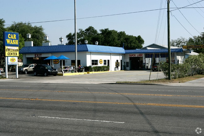
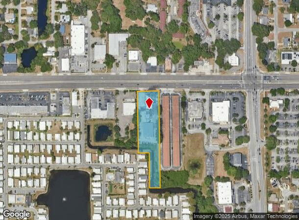
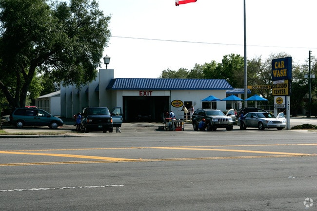
Property Record
1435 Main St, Dunedin, FL 34698
NEARBY LISTINGS FOR SALE OR LEASE
Property Detail
1435 Main St
26-28-15-00000-410-0301
From Ne Cor Of Se 1/4 Th W
Carwash
FROM NE COR OF SE 1/4 TH W W 703.8FT TH S 66FT(S) FOR POB TH S 679.7FT TH W 74.3 FT TH N 245FT TH W 77.8FT TH N 434.6FT TH E 150FT(S) TO POB CONT 1.97AC(C)
AO
Pinellas
12103C0069H
Florida
2024
1.92 AC
2025
North Pinellas
026914
Tampa/St Petersburg
13,555 SF
Tampa-St. Petersburg-Clearwater, FL
DEMOGRAPHICS near 1435 Main St
1 mile
3 mile
5 mile
2024 Total Population
13,958
93,051
218,824
2029 Population
14,109
93,476
219,337
Pop Growth 2024-2029
+ 1.08%
+ 0.46%
+ 0.23%
Average Age
53
49
47
2024 Total Households
7,061
44,556
100,054
HH Growth 2024-2029
+ 0.98%
+ 0.34%
+ 0.16%
Median Household Inc
$50,671
$55,994
$59,199
Avg Household Size
1.90
2.00
2.10
2024 Avg HH Vehicles
1.00
1.00
2.00
Median Home Value
$255,568
$258,948
$289,367
Median Year Built
1975
1977
1979
Nearby Places
Map Layers
Map Styles
 Street
 Aerial
Transit
 Traffic
 Biking
Places
Listings with unknown addresses are not visible on the map
- Restaurants
- Banks
- Shops
- Fitness
- Groceries
PUBLIC TRANSPORTATION
AIRPORT
St Pete-Clearwater International
Drive
Walk
Distance
St Pete-Clearwater International
30 min
15.6 mi
Tampa International
Drive
Walk
Distance
Tampa International
33 min
19.8 mi
Freight Ports
Port of Tampa Bay
Drive
Walk
Distance
Port of Tampa Bay
46 min
28.2 mi
Nearby Properties
Address
Land Use
TOTAL SIZE
Lot Size
Zoning
Address
Land Use
TOTAL SIZE
Lot Size
Zoning
675,202 SF
43.24 AC
Address
Land Use
TOTAL SIZE
Lot Size
Zoning
724,220 SF
22.95 AC
Address
Land Use
TOTAL SIZE
Lot Size
Zoning
460,041 SF
44.28 AC
Address
Land Use
TOTAL SIZE
Lot Size
Zoning
167,201 SF
63.11 AC
AE
Address
Land Use
TOTAL SIZE
Lot Size
Zoning
406,729 SF
29.79 AC
CP1
Address
Land Use
TOTAL SIZE
Lot Size
Zoning
412,099 SF
49.21 AC
Address
Land Use
TOTAL SIZE
Lot Size
Zoning
278,505 SF
38.67 AC
Address
Land Use
TOTAL SIZE
Lot Size
Zoning
362,238 SF
13.80 AC
Address
Land Use
TOTAL SIZE
Lot Size
Zoning
215,081 SF
16.60 AC
Address
Land Use
TOTAL SIZE
Lot Size
Zoning
367,503 SF
20.34 AC
M2
Address
Land Use
TOTAL SIZE
Lot Size
Zoning
117,024 SF
56.52 AC
Address
Land Use
TOTAL SIZE
Lot Size
Zoning
241,170 SF
17.23 AC
Address
Land Use
TOTAL SIZE
Lot Size
Zoning
151,730 SF
49.66 AC
Address
Land Use
TOTAL SIZE
Lot Size
Zoning
161,404 SF
18.48 AC
CP2
Address
Land Use
TOTAL SIZE
Lot Size
Zoning
16,007 SF
55.89 AC
Address
Land Use
TOTAL SIZE
Lot Size
Zoning
191,375 SF
13.58 AC
AE
Address
Land Use
TOTAL SIZE
Lot Size
Zoning
186,967 SF
16.86 AC
Address
Land Use
TOTAL SIZE
Lot Size
Zoning
250,113 SF
39.50 AC
Address
Land Use
TOTAL SIZE
Lot Size
Zoning
196,808 SF
12.70 AC
Address
Land Use
TOTAL SIZE
Lot Size
Zoning
11,366 SF
43.16 AC
Address
Land Use
TOTAL SIZE
Lot Size
Zoning
220,640 SF
9.02 AC
Address
Land Use
TOTAL SIZE
Lot Size
Zoning
201,208 SF
2.16 AC
Address
Land Use
TOTAL SIZE
Lot Size
Zoning
228,493 SF
21.21 AC
Address
Land Use
TOTAL SIZE
Lot Size
Zoning
173,160 SF
5.39 AC
Address
Land Use
TOTAL SIZE
Lot Size
Zoning
107,766 SF
25.15 AC
Address
Land Use
TOTAL SIZE
Lot Size
Zoning
158,400 SF
9.80 AC
Address
Land Use
TOTAL SIZE
Lot Size
Zoning
396,841 SF
9.73 AC
Address
Land Use
TOTAL SIZE
Lot Size
Zoning
130,628 SF
10.26 AC
Address
Land Use
TOTAL SIZE
Lot Size
Zoning
118,028 SF
11.90 AC
RR
Address
Land Use
TOTAL SIZE
Lot Size
Zoning
415,593 SF
29.66 AC
The World's #1 Commercial Real Estate Marketplace
Connect with us
© 2026 CoStar Group
The information above has been obtained from sources believed reliable. While we do not doubt its accuracy we have not verified it and make no guarantee, warranty or representation about it. It is your responsibility to independently confirm its accuracy and completeness. Any projections, opinions, assumptions, or estimates used are for example only and do not represent the current or future performance of the property. The value of this transaction to you depends on tax and other factors which should be evaluated by your tax, financial, and legal advisors. You and your advisors should conduct a careful, independent investigation of the property to determine to your satisfaction the suitability of the property for your needs.