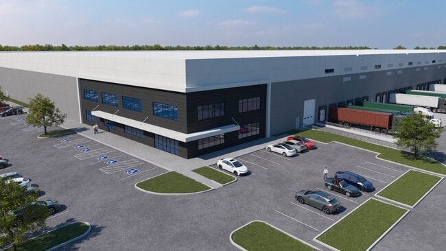
Property Record
1435 State St, White Haven, PA 18661

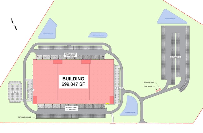
Current Lease Availabilities
NEARBY LISTINGS FOR SALE OR LEASE
Property Detail
1435 State St
Allentown-Bethlehem-Easton, PA-NJ
Carbon
32-20-A2A
Pennsylvania
Vacantlandnec
117.89 AC
2025
Lehigh Valley
2025
Philadelphia
215400
DEMOGRAPHICS near 1435 State St
1 Mile
3 Mile
5 Mile
2024 Total Population
10
1,478
2,988
2029 Population
10
1,371
2,856
Pop Growth 2024-2029
0.00%
(7.24%)
(4.42%)
Average Age
60
47
47
2024 Total Households
5
660
1,321
HH Growth 2024-2029
0.00%
(7.12%)
(4.47%)
Median Household Inc
$29,999
$85,351
$73,511
Avg Household Size
1.80
2.20
2.20
2024 Avg HH Vehicles
2.00
2.00
2.00
Median Home Value
$250,000
$230,981
$217,971
Median Year Built
1984
1983
1983
Nearby Places
Map Layers
Map Styles
 Street
 Aerial
- Restaurants
- Banks
- Shops
- Fitness
- Groceries
PUBLIC TRANSPORTATION
AIRPORT
Wilkes-Barre/Scranton International
DRIVE
WALK
Distance
Wilkes-Barre/Scranton International
39 min
28.6 mi
Freight Ports
Maher Terminal
DRIVE
WALK
Distance
Maher Terminal
123 min
96.9 mi
Nearby Properties
Address
Land Use
TOTAL SIZE
Lot Size
Zoning
Address
Land Use
TOTAL SIZE
Lot Size
Zoning
1,003,800 SF
207.10 AC
CI
Address
Land Use
TOTAL SIZE
Lot Size
Zoning
1,456 SF
253 AC
Address
Land Use
TOTAL SIZE
Lot Size
Zoning
65,104 SF
35.73 AC
C
Address
Land Use
TOTAL SIZE
Lot Size
Zoning
28,000 SF
7.12 AC
C
Address
Land Use
TOTAL SIZE
Lot Size
Zoning
48,196 SF
4.39 AC
CI
Address
Land Use
TOTAL SIZE
Lot Size
Zoning
640 SF
178.92 AC
Address
Land Use
TOTAL SIZE
Lot Size
Zoning
36.60 AC
Address
Land Use
TOTAL SIZE
Lot Size
Zoning
5,712 SF
2.82 AC
C
Address
Land Use
TOTAL SIZE
Lot Size
Zoning
12,589 SF
4.05 AC
C
Address
Land Use
TOTAL SIZE
Lot Size
Zoning
3,282 SF
19.45 AC
C
Address
Land Use
TOTAL SIZE
Lot Size
Zoning
7,462 SF
4.55 AC
CI
Address
Land Use
TOTAL SIZE
Lot Size
Zoning
1,296 SF
245.49 AC
Address
Land Use
TOTAL SIZE
Lot Size
Zoning
10,107 SF
0.35 AC
C
Address
Land Use
TOTAL SIZE
Lot Size
Zoning
7,124 SF
3.87 AC
CI
Address
Land Use
TOTAL SIZE
Lot Size
Zoning
2,872 SF
0.61 AC
C
Address
Land Use
TOTAL SIZE
Lot Size
Zoning
438.14 AC
OS
Address
Land Use
TOTAL SIZE
Lot Size
Zoning
3,000 SF
1.17 AC
C-2
Address
Land Use
TOTAL SIZE
Lot Size
Zoning
40.90 AC
Address
Land Use
TOTAL SIZE
Lot Size
Zoning
100 SF
2.30 AC
C
Address
Land Use
TOTAL SIZE
Lot Size
Zoning
Address
Land Use
TOTAL SIZE
Lot Size
Zoning
9,687 SF
20.81 AC
Address
Land Use
TOTAL SIZE
Lot Size
Zoning
10,748 SF
3.01 AC
CI
Address
Land Use
TOTAL SIZE
Lot Size
Zoning
7,358 SF
2.32 AC
C
Address
Land Use
TOTAL SIZE
Lot Size
Zoning
87.01 AC
R-2
Address
Land Use
TOTAL SIZE
Lot Size
Zoning
12,632 SF
3 AC
CI
Address
Land Use
TOTAL SIZE
Lot Size
Zoning
7,905 SF
1.93 AC
C
Address
Land Use
TOTAL SIZE
Lot Size
Zoning
5,100 SF
3.62 AC
C
Address
Land Use
TOTAL SIZE
Lot Size
Zoning
Address
Land Use
TOTAL SIZE
Lot Size
Zoning
12,300 SF
1.84 AC
C
Address
Land Use
TOTAL SIZE
Lot Size
Zoning
5,346 SF
2.84 AC
C
The World's #1 Commercial Real Estate Marketplace
Connect with us
© 2026 CoStar Group
The information above has been obtained from sources believed reliable. While we do not doubt its accuracy we have not verified it and make no guarantee, warranty or representation about it. It is your responsibility to independently confirm its accuracy and completeness. Any projections, opinions, assumptions, or estimates used are for example only and do not represent the current or future performance of the property. The value of this transaction to you depends on tax and other factors which should be evaluated by your tax, financial, and legal advisors. You and your advisors should conduct a careful, independent investigation of the property to determine to your satisfaction the suitability of the property for your needs.