Property Record
1435 Wait Ave, Wake Forest, NC 27587
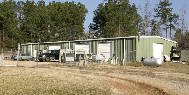

Property Detail
1435 Wait Ave
1850.01-38-7278-000
GEORGE C MACKIE JR & MARTHA H MACKIE REM
Warehouse
WAKE
LI
North Carolina
2025
14.79 AC
2025
Route 1
054206
Raleigh/Durham
4,300 SF
Raleigh-Cary, NC
NEARBY LISTINGS FOR SALE OR LEASE
-
-
View all Wake Forest listings for sale on LoopNet.com
DEMOGRAPHICS near 1435 Wait Ave
1 mile
3 mile
5 mile
2025 Total Population
6,921
49,825
98,348
2030 Population
7,596
54,727
107,710
Pop Growth 2025-2030
+ 9.75%
+ 9.84%
+ 9.52%
Average Age
39
39
40
2025 Total Households
2,334
17,897
35,519
HH Growth 2025-2030
+ 10.15%
+ 10.24%
+ 9.94%
Median Household Inc
$160,924
$123,345
$117,425
Avg Household Size
3.00
2.70
2.70
2025 Avg HH Vehicles
2.00
2.00
2.00
Median Home Value
$515,426
$477,931
$476,967
Median Year Built
2010
2009
2007
Nearby Places
Map Layers
Map Styles
 Street
 Aerial
Layers
 Traffic
 Biking
Places
Listings with unknown addresses are not visible on the map
- Restaurants
- Banks
- Shops
- Fitness
- Groceries
PUBLIC TRANSPORTATION
AIRPORT
Raleigh-Durham International
Drive
Walk
Distance
Raleigh-Durham International
35 min
23.2 mi
Nearby Properties
Address
Land Use
TOTAL SIZE
Lot Size
Zoning
Address
Land Use
TOTAL SIZE
Lot Size
Zoning
378,421 SF
19.06 AC
RMX
Address
Land Use
TOTAL SIZE
Lot Size
Zoning
283,870 SF
11.39 AC
RMX
Address
Land Use
TOTAL SIZE
Lot Size
Zoning
442,480 SF
52.02 AC
GR3
Address
Land Use
TOTAL SIZE
Lot Size
Zoning
263,777 SF
93.84 AC
GR3
Address
Land Use
TOTAL SIZE
Lot Size
Zoning
232,734 SF
57.28 AC
GR3
Address
Land Use
TOTAL SIZE
Lot Size
Zoning
243,797 SF
22.57 AC
GR10
Address
Land Use
TOTAL SIZE
Lot Size
Zoning
248,945 SF
16.41 AC
GR10
Address
Land Use
TOTAL SIZE
Lot Size
Zoning
225,390 SF
14.95 AC
GR10
Address
Land Use
TOTAL SIZE
Lot Size
Zoning
283,795 SF
31.33 AC
ICD
Address
Land Use
TOTAL SIZE
Lot Size
Zoning
162,909 SF
9.84 AC
RMX
Address
Land Use
TOTAL SIZE
Lot Size
Zoning
136,644 SF
4.38 AC
RMX
Address
Land Use
TOTAL SIZE
Lot Size
Zoning
186,546 SF
6.84 AC
RMX
Address
Land Use
TOTAL SIZE
Lot Size
Zoning
166,192 SF
13.59 AC
GR10
Address
Land Use
TOTAL SIZE
Lot Size
Zoning
143,060 SF
7.19 AC
RMX
Address
Land Use
TOTAL SIZE
Lot Size
Zoning
154,602 SF
40 AC
ICD
Address
Land Use
TOTAL SIZE
Lot Size
Zoning
137,650 SF
36.63 AC
GR5
Address
Land Use
TOTAL SIZE
Lot Size
Zoning
84,528 SF
14.44 AC
NB
Address
Land Use
TOTAL SIZE
Lot Size
Zoning
111,616 SF
4.69 AC
NMX
Address
Land Use
TOTAL SIZE
Lot Size
Zoning
107,082 SF
4.17 AC
RMX
Address
Land Use
TOTAL SIZE
Lot Size
Zoning
210,619 SF
18.73 AC
HB
Address
Land Use
TOTAL SIZE
Lot Size
Zoning
91,233 SF
11.04 AC
GR10
Address
Land Use
TOTAL SIZE
Lot Size
Zoning
88,053 SF
12.16 AC
GR10
Address
Land Use
TOTAL SIZE
Lot Size
Zoning
103,310 SF
6.29 AC
RMX
Address
Land Use
TOTAL SIZE
Lot Size
Zoning
101,307 SF
21 AC
HB
Address
Land Use
TOTAL SIZE
Lot Size
Zoning
117,680 SF
11.99 AC
GR10
Address
Land Use
TOTAL SIZE
Lot Size
Zoning
160,525 SF
20.02 AC
IND
Address
Land Use
TOTAL SIZE
Lot Size
Zoning
58,211 SF
6.96 AC
NMX
Address
Land Use
TOTAL SIZE
Lot Size
Zoning
102,578 SF
14 AC
PUD
Address
Land Use
TOTAL SIZE
Lot Size
Zoning
61,138 SF
36.70 AC
GR3
Address
Land Use
TOTAL SIZE
Lot Size
Zoning
364,500 SF
30.25 AC
IND
The World's #1 Commercial Real Estate Marketplace
Connect with us
© 2026 CoStar Group
The information above has been obtained from sources believed reliable. While we do not doubt its accuracy we have not verified it and make no guarantee, warranty or representation about it. It is your responsibility to independently confirm its accuracy and completeness. Any projections, opinions, assumptions, or estimates used are for example only and do not represent the current or future performance of the property. The value of this transaction to you depends on tax and other factors which should be evaluated by your tax, financial, and legal advisors. You and your advisors should conduct a careful, independent investigation of the property to determine to your satisfaction the suitability of the property for your needs.