Property Record
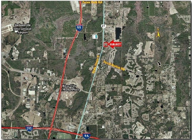
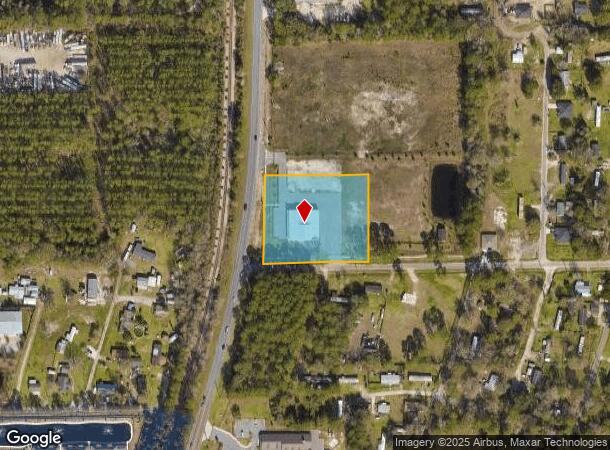
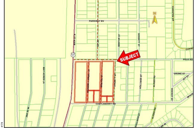
14353 N Main St, Jacksonville, FL 32218
NEARBY LISTINGS FOR SALE OR LEASE
Property Detail
14353 N Main St
Jacksonville, FL
Duval City
107849-0000
6-9 20-1N-27E 2.38 DUVAL CITY PT BLKS 34,35, PT CLSD RD RECD O/R 20361-1604
Warehouse
Duval
X
Florida
12031C0201J
1-14
2025
2.38 AC
2026
Northeast Jacksonville
010308
Jacksonville (Florida)
10,600 SF
DEMOGRAPHICS near 14353 N Main St
1 Mile
3 Mile
5 Mile
2024 Total Population
4,031
28,136
58,728
2029 Population
4,268
29,973
61,993
Pop Growth 2024-2029
+ 5.88%
+ 6.53%
+ 5.56%
Average Age
37
37
38
2024 Total Households
1,510
10,479
21,824
HH Growth 2024-2029
+ 6.29%
+ 6.98%
+ 5.85%
Median Household Inc
$85,494
$73,872
$73,902
Avg Household Size
2.60
2.60
2.60
2024 Avg HH Vehicles
2.00
2.00
2.00
Median Home Value
$262,535
$258,903
$259,509
Median Year Built
2006
2006
2002
Nearby Places
Map Layers
Map Styles
 Street
 Aerial
- Restaurants
- Banks
- Shops
- Fitness
- Groceries
PUBLIC TRANSPORTATION
AIRPORT
Jacksonville International
DRIVE
WALK
Distance
Jacksonville International
11 min
5.5 mi
Freight Ports
Jacksonville Port
DRIVE
WALK
Distance
Jacksonville Port
21 min
11.0 mi
SALE & LEASE HISTORY
LISTING DATE
SALE/LEASE

Sep 24, 2016
For Sale
Nearby Properties
Address
Land Use
TOTAL SIZE
Lot Size
Zoning
Address
Land Use
TOTAL SIZE
Lot Size
Zoning
344,800 SF
35.11 AC
PUD
Address
Land Use
TOTAL SIZE
Lot Size
Zoning
371,466 SF
42.67 AC
PUD
Address
Land Use
TOTAL SIZE
Lot Size
Zoning
226,421 SF
1.89 AC
PUD
Address
Land Use
TOTAL SIZE
Lot Size
Zoning
846,897 SF
47.02 AC
PUD
Address
Land Use
TOTAL SIZE
Lot Size
Zoning
201,630 SF
21.59 AC
PUD
Address
Land Use
TOTAL SIZE
Lot Size
Zoning
307,351 SF
34.25 AC
PUD
Address
Land Use
TOTAL SIZE
Lot Size
Zoning
328,039 SF
18.88 AC
PUD
Address
Land Use
TOTAL SIZE
Lot Size
Zoning
240,988 SF
18.11 AC
PUD
Address
Land Use
TOTAL SIZE
Lot Size
Zoning
210,341 SF
8.84 AC
PUD
Address
Land Use
TOTAL SIZE
Lot Size
Zoning
237,807 SF
13.52 AC
CRO
Address
Land Use
TOTAL SIZE
Lot Size
Zoning
640,660 SF
28.30 AC
PUD
Address
Land Use
TOTAL SIZE
Lot Size
Zoning
317,695 SF
15.88 AC
PUD
Address
Land Use
TOTAL SIZE
Lot Size
Zoning
317,815 SF
17.56 AC
PUD
Address
Land Use
TOTAL SIZE
Lot Size
Zoning
163,276 SF
8.39 AC
PUD
Address
Land Use
TOTAL SIZE
Lot Size
Zoning
197,526 SF
11.98 AC
PUD
Address
Land Use
TOTAL SIZE
Lot Size
Zoning
226,572 SF
9.24 AC
PUD
Address
Land Use
TOTAL SIZE
Lot Size
Zoning
336,566 SF
25.63 AC
PUD
Address
Land Use
TOTAL SIZE
Lot Size
Zoning
320,372 SF
18.41 AC
PUD
Address
Land Use
TOTAL SIZE
Lot Size
Zoning
264,117 SF
22.48 AC
PUD
Address
Land Use
TOTAL SIZE
Lot Size
Zoning
104,353 SF
6.57 AC
CRO
Address
Land Use
TOTAL SIZE
Lot Size
Zoning
117,647 SF
10.17 AC
PUD
Address
Land Use
TOTAL SIZE
Lot Size
Zoning
201,300 SF
15.83 AC
PUD
Address
Land Use
TOTAL SIZE
Lot Size
Zoning
48,309 SF
4.03 AC
CCG-1
Address
Land Use
TOTAL SIZE
Lot Size
Zoning
86,637 SF
8.09 AC
CCG-1
Address
Land Use
TOTAL SIZE
Lot Size
Zoning
90,363 SF
11.12 AC
PUD
Address
Land Use
TOTAL SIZE
Lot Size
Zoning
235,864 SF
18.14 AC
PUD
Address
Land Use
TOTAL SIZE
Lot Size
Zoning
110,968 SF
5.75 AC
PUD
Address
Land Use
TOTAL SIZE
Lot Size
Zoning
28,653 SF
2.89 AC
PUD
Address
Land Use
TOTAL SIZE
Lot Size
Zoning
229,225 SF
15.98 AC
PUD
Address
Land Use
TOTAL SIZE
Lot Size
Zoning
158,112 SF
9.93 AC
IBP
The World's #1 Commercial Real Estate Marketplace
Connect with us
© 2026 CoStar Group
The information above has been obtained from sources believed reliable. While we do not doubt its accuracy we have not verified it and make no guarantee, warranty or representation about it. It is your responsibility to independently confirm its accuracy and completeness. Any projections, opinions, assumptions, or estimates used are for example only and do not represent the current or future performance of the property. The value of this transaction to you depends on tax and other factors which should be evaluated by your tax, financial, and legal advisors. You and your advisors should conduct a careful, independent investigation of the property to determine to your satisfaction the suitability of the property for your needs.