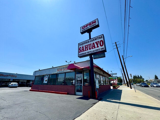
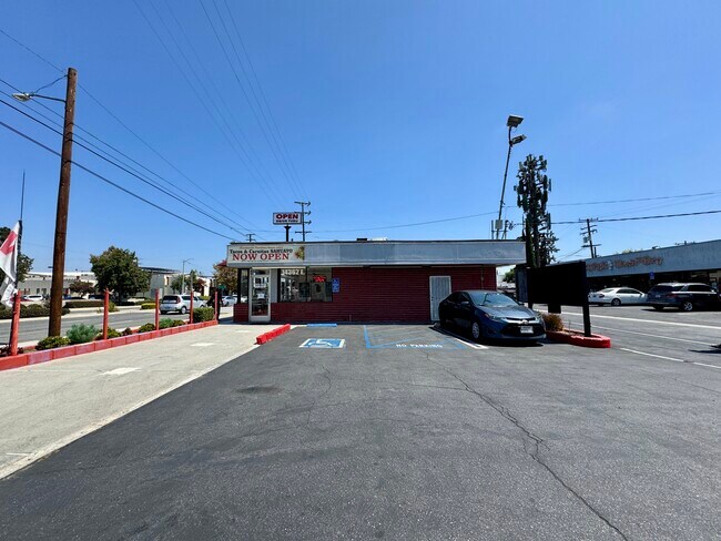
Property Record
14356 Telegraph Rd, Whittier, CA 90604


Property Detail
14356 Telegraph Rd
8030-002-029
TRACT NO 10100 LOTS 64,65 AND LOT 66
Storemultistory
Los Angeles
LCC4*
California
B and X Area of moderate flood hazard, usually the area between the limits of the 100-year and 500-year floods.
64
2025
0.52 AC
2025
Southeast Los Angeles
503106
Los Angeles
7,655 SF
Los Angeles-Long Beach-Glendale, CA
NEARBY LISTINGS FOR SALE OR LEASE
DEMOGRAPHICS near 14356 Telegraph Rd
1 mile
3 mile
5 mile
2025 Total Population
30,083
174,266
494,760
2030 Population
29,782
172,131
489,361
Pop Growth 2025-2030
(1.00%)
(1.23%)
(1.09%)
Average Age
40
40
40
2025 Total Households
8,744
51,914
148,100
HH Growth 2025-2030
(1.18%)
(1.51%)
(1.32%)
Median Household Inc
$102,929
$104,139
$102,859
Avg Household Size
3.30
3.20
3.20
2025 Avg HH Vehicles
2.00
2.00
2.00
Median Home Value
$731,467
$754,061
$770,475
Median Year Built
1957
1958
1960
Nearby Places
Map Layers
Map Styles
 Street
 Aerial
Layers
 Traffic
 Biking
Places
Listings with unknown addresses are not visible on the map
- Restaurants
- Banks
- Shops
- Fitness
- Groceries
PUBLIC TRANSPORTATION
COMMUTER RAIL
Norwalk/Santa Fe Springs (91 Line - Southern California Regional Rail Authority (Metrolink), Orange County Line - Southern California Regional Rail Authority (Metrolink))
Drive
Walk
Distance
Norwalk/Santa Fe Springs (91 Line - Southern California Regional Rail Authority (Metrolink), Orange County Line - Southern California Regional Rail Authority (Metrolink))
5 min
2.2 mi
Buena Park (91 Line - Southern California Regional Rail Authority (Metrolink), Orange County Line - Southern California Regional Rail Authority (Metrolink))
Drive
Walk
Distance
Buena Park (91 Line - Southern California Regional Rail Authority (Metrolink), Orange County Line - Southern California Regional Rail Authority (Metrolink))
8 min
4.6 mi
AIRPORT
Long Beach (Daugherty Field)
Drive
Walk
Distance
Long Beach (Daugherty Field)
27 min
16.0 mi
John Wayne/Orange County
Drive
Walk
Distance
John Wayne/Orange County
31 min
23.6 mi
Los Angeles International
Drive
Walk
Distance
Los Angeles International
33 min
24.1 mi
Freight Ports
Port of Long Beach
Drive
Walk
Distance
Port of Long Beach
32 min
20.7 mi
SALE & LEASE HISTORY
LISTING DATE
SALE/LEASE

Sep 02, 2025
For Lease
Nearby Properties
Address
Land Use
TOTAL SIZE
Lot Size
Zoning
Address
Land Use
TOTAL SIZE
Lot Size
Zoning
1,100,900 SF
22.36 AC
SSM2*
Address
Land Use
TOTAL SIZE
Lot Size
Zoning
634,060 SF
76.06 AC
SSM2
Address
Land Use
TOTAL SIZE
Lot Size
Zoning
150,561 SF
65.24 AC
LMPUD
Address
Land Use
TOTAL SIZE
Lot Size
Zoning
476,442 SF
22.77 AC
Address
Land Use
TOTAL SIZE
Lot Size
Zoning
564,705 SF
14.35 AC
LCA25*
Address
Land Use
TOTAL SIZE
Lot Size
Zoning
225,016 SF
9.95 AC
LMM2*
Address
Land Use
TOTAL SIZE
Lot Size
Zoning
166,712 SF
8.53 AC
NOM1(PF)-P
Address
Land Use
TOTAL SIZE
Lot Size
Zoning
322,048 SF
15.54 AC
SSM2-M1*
Address
Land Use
TOTAL SIZE
Lot Size
Zoning
224,131 SF
9.03 AC
CEM
Address
Land Use
TOTAL SIZE
Lot Size
Zoning
304,549 SF
7.13 AC
SSM2*
Address
Land Use
TOTAL SIZE
Lot Size
Zoning
345,200 SF
8.51 AC
LMM2
Address
Land Use
TOTAL SIZE
Lot Size
Zoning
518,296 SF
13.94 AC
NOCO(PF)*
Address
Land Use
TOTAL SIZE
Lot Size
Zoning
128,481 SF
19.42 AC
LMR1*
Address
Land Use
TOTAL SIZE
Lot Size
Zoning
300,148 SF
13.01 AC
SSM2*
Address
Land Use
TOTAL SIZE
Lot Size
Zoning
163,350 SF
7.58 AC
CEM
Address
Land Use
TOTAL SIZE
Lot Size
Zoning
154,616 SF
7.53 AC
CEM
Address
Land Use
TOTAL SIZE
Lot Size
Zoning
176,103 SF
SSM2YY
Address
Land Use
TOTAL SIZE
Lot Size
Zoning
237,944 SF
12.09 AC
LMM2*
Address
Land Use
TOTAL SIZE
Lot Size
Zoning
444,784 SF
18.92 AC
SSM2*
Address
Land Use
TOTAL SIZE
Lot Size
Zoning
41,100 SF
8.42 AC
SSM2*
Address
Land Use
TOTAL SIZE
Lot Size
Zoning
289,454 SF
13.66 AC
SSM2*
Address
Land Use
TOTAL SIZE
Lot Size
Zoning
158,272 SF
7.09 AC
SSPF*
Address
Land Use
TOTAL SIZE
Lot Size
Zoning
140,212 SF
6.65 AC
LMM2*
Address
Land Use
TOTAL SIZE
Lot Size
Zoning
89,899 SF
SSM2*
Address
Land Use
TOTAL SIZE
Lot Size
Zoning
73,661 SF
4.25 AC
SSR1
Address
Land Use
TOTAL SIZE
Lot Size
Zoning
834,952 SF
33.06 AC
SSM2
Address
Land Use
TOTAL SIZE
Lot Size
Zoning
168,912 SF
8.09 AC
CEM
Address
Land Use
TOTAL SIZE
Lot Size
Zoning
124,820 SF
4.11 AC
NOM2*
Address
Land Use
TOTAL SIZE
Lot Size
Zoning
89,514 SF
21.28 AC
WHC2*
Address
Land Use
TOTAL SIZE
Lot Size
Zoning
500,374 SF
9.46 AC
SSM2*
The World's #1 Commercial Real Estate Marketplace
Connect with us
© 2026 CoStar Group
The information above has been obtained from sources believed reliable. While we do not doubt its accuracy we have not verified it and make no guarantee, warranty or representation about it. It is your responsibility to independently confirm its accuracy and completeness. Any projections, opinions, assumptions, or estimates used are for example only and do not represent the current or future performance of the property. The value of this transaction to you depends on tax and other factors which should be evaluated by your tax, financial, and legal advisors. You and your advisors should conduct a careful, independent investigation of the property to determine to your satisfaction the suitability of the property for your needs.