Property Record
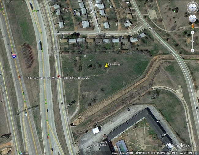
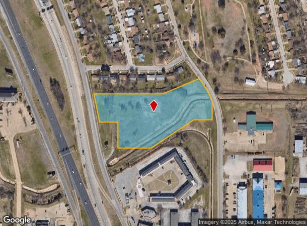
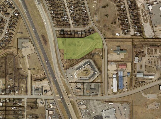
1437 Central Fwy, Wichita Falls, TX 76306
NEARBY LISTINGS FOR SALE OR LEASE
Property Detail
1437 Central Fwy
Wichita Falls, TX
Abst. 481 - E.
123416
4.68 AC A-481 E SCURRY
Residentialacreage
Wichita
X
Texas
48485C0310G
4.68 AC
2024
North Wichita Falls
2025
Other Market Areas
013201
DEMOGRAPHICS near 1437 Central Fwy
1 Mile
3 Mile
5 Mile
2024 Total Population
3,368
32,887
67,524
2029 Population
3,505
33,973
69,488
Pop Growth 2024-2029
+ 4.07%
+ 3.30%
+ 2.91%
Average Age
38
35
37
2024 Total Households
1,305
11,350
25,351
HH Growth 2024-2029
+ 4.21%
+ 3.87%
+ 3.15%
Median Household Inc
$40,630
$41,006
$45,350
Avg Household Size
2.40
2.40
2.30
2024 Avg HH Vehicles
1.00
2.00
2.00
Median Home Value
$51,510
$80,384
$105,931
Median Year Built
1966
1963
1965
Nearby Places
Map Layers
Map Styles
 Street
 Aerial
- Restaurants
- Banks
- Shops
- Fitness
- Groceries
SALE & LEASE HISTORY
LISTING DATE
SALE/LEASE

Mar 23, 2017
For Sale
Apr 08, 2024
For Sale
Nearby Properties
Address
Land Use
TOTAL SIZE
Lot Size
Zoning
Address
Land Use
TOTAL SIZE
Lot Size
Zoning
1,809,480 SF
132.45 AC
Address
Land Use
TOTAL SIZE
Lot Size
Zoning
4,501.47 AC
Address
Land Use
TOTAL SIZE
Lot Size
Zoning
164,255 SF
5.23 AC
Address
Land Use
TOTAL SIZE
Lot Size
Zoning
398,646 SF
7.51 AC
GC
Address
Land Use
TOTAL SIZE
Lot Size
Zoning
203,569 SF
27.74 AC
Address
Land Use
TOTAL SIZE
Lot Size
Zoning
245,152 SF
5.12 AC
GC
Address
Land Use
TOTAL SIZE
Lot Size
Zoning
233,084 SF
44.31 AC
SF2
Address
Land Use
TOTAL SIZE
Lot Size
Zoning
24,741 SF
37.75 AC
Address
Land Use
TOTAL SIZE
Lot Size
Zoning
200,421 SF
18.57 AC
MFR
Address
Land Use
TOTAL SIZE
Lot Size
Zoning
158,784 SF
69.19 AC
Address
Land Use
TOTAL SIZE
Lot Size
Zoning
167,247 SF
2.61 AC
CBD
Address
Land Use
TOTAL SIZE
Lot Size
Zoning
51,240 SF
3.46 AC
GC
Address
Land Use
TOTAL SIZE
Lot Size
Zoning
125,992 SF
4.22 AC
Address
Land Use
TOTAL SIZE
Lot Size
Zoning
80,294 SF
9.17 AC
Address
Land Use
TOTAL SIZE
Lot Size
Zoning
120,073 SF
17.43 AC
Address
Land Use
TOTAL SIZE
Lot Size
Zoning
136,522 SF
4.11 AC
Address
Land Use
TOTAL SIZE
Lot Size
Zoning
95,926 SF
1.21 AC
CBD
Address
Land Use
TOTAL SIZE
Lot Size
Zoning
101,451 SF
11.91 AC
RMU
Address
Land Use
TOTAL SIZE
Lot Size
Zoning
86,163 SF
10.89 AC
SF2
Address
Land Use
TOTAL SIZE
Lot Size
Zoning
125,809 SF
2.01 AC
GC
Address
Land Use
TOTAL SIZE
Lot Size
Zoning
131,525 SF
4,501.50 AC
Address
Land Use
TOTAL SIZE
Lot Size
Zoning
108,972 SF
1.41 AC
CBD
Address
Land Use
TOTAL SIZE
Lot Size
Zoning
183,184 SF
21.89 AC
GC
Address
Land Use
TOTAL SIZE
Lot Size
Zoning
115,350 SF
4.86 AC
SF2
Address
Land Use
TOTAL SIZE
Lot Size
Zoning
34,268 SF
1.27 AC
Address
Land Use
TOTAL SIZE
Lot Size
Zoning
143,878 SF
20.85 AC
MFR
Address
Land Use
TOTAL SIZE
Lot Size
Zoning
64,637 SF
25.40 AC
Address
Land Use
TOTAL SIZE
Lot Size
Zoning
115,934 SF
2.63 AC
RDD
Address
Land Use
TOTAL SIZE
Lot Size
Zoning
138,450 SF
2.61 AC
CBD
Address
Land Use
TOTAL SIZE
Lot Size
Zoning
78,016 SF
16.97 AC
The World's #1 Commercial Real Estate Marketplace
Connect with us
© 2025 CoStar Group
The information above has been obtained from sources believed reliable. While we do not doubt its accuracy we have not verified it and make no guarantee, warranty or representation about it. It is your responsibility to independently confirm its accuracy and completeness. Any projections, opinions, assumptions, or estimates used are for example only and do not represent the current or future performance of the property. The value of this transaction to you depends on tax and other factors which should be evaluated by your tax, financial, and legal advisors. You and your advisors should conduct a careful, independent investigation of the property to determine to your satisfaction the suitability of the property for your needs.