Property Record
1437 N Us Highway 1, Ormond Beach, FL 32174
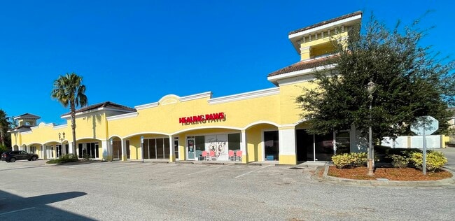

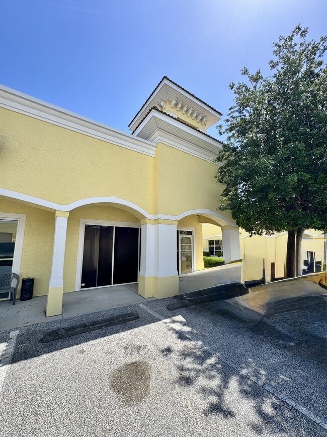
This Property Is For Sale
Property Detail
1437 N Us Highway 1
3136-04-0C-00C6
UNIT C6 BLDG C MBA BUSINESS CENTER CONDO PER OR 5566 PG 2669 PER OR 6314 PG 3857 PER OR 8148 PG 1253
Regionalshoppingcenterormallwithanchorstore
Volusia
MPUD
Florida
B and X Area of moderate flood hazard, usually the area between the limits of the 100-year and 500-year floods.
0.03 AC
2025
Ormond Beach
2026
Deltona/Daytona Beach
080102
Deltona-Daytona Beach-Ormond Beach, FL
1,366 SF
NEARBY LISTINGS FOR SALE OR LEASE
DEMOGRAPHICS near 1437 N Us Highway 1
1 mile
3 mile
5 mile
2025 Total Population
1,462
8,741
52,299
2030 Population
1,575
9,366
56,794
Pop Growth 2025-2030
+ 7.73%
+ 7.15%
+ 8.59%
Average Age
49
51
51
2025 Total Households
617
3,894
24,136
HH Growth 2025-2030
+ 7.62%
+ 7.09%
+ 8.72%
Median Household Inc
$91,313
$83,129
$70,993
Avg Household Size
2.30
2.20
2.10
2025 Avg HH Vehicles
2.00
2.00
2.00
Median Home Value
$446,022
$422,750
$403,611
Median Year Built
1989
1996
1986
Nearby Places
Map Layers
Map Styles
 Street
 Aerial
Transit
 Traffic
 Biking
Places
Listings with unknown addresses are not visible on the map
- Restaurants
- Banks
- Shops
- Fitness
- Groceries
PUBLIC TRANSPORTATION
AIRPORT
Daytona Beach International
Drive
Walk
Distance
Daytona Beach International
21 min
15.2 mi
Freight Ports
Port Canaveral
Drive
Walk
Distance
Port Canaveral
94 min
82.4 mi
Nearby Properties
Address
Land Use
TOTAL SIZE
Lot Size
Zoning
Address
Land Use
TOTAL SIZE
Lot Size
Zoning
13,846 SF
126.83 AC
13T1
Address
Land Use
TOTAL SIZE
Lot Size
Zoning
137,934 SF
48.30 AC
Address
Land Use
TOTAL SIZE
Lot Size
Zoning
5,350 SF
36.42 AC
13T1
Address
Land Use
TOTAL SIZE
Lot Size
Zoning
196,932 SF
12.44 AC
BPUD
Address
Land Use
TOTAL SIZE
Lot Size
Zoning
161,123 SF
13.56 AC
I1
Address
Land Use
TOTAL SIZE
Lot Size
Zoning
209,984 SF
24.14 AC
I1
Address
Land Use
TOTAL SIZE
Lot Size
Zoning
87,633 SF
568.97 AC
RR
Address
Land Use
TOTAL SIZE
Lot Size
Zoning
106,488 SF
27.60 AC
MPUD
Address
Land Use
TOTAL SIZE
Lot Size
Zoning
127,463 SF
5.50 AC
01B2
Address
Land Use
TOTAL SIZE
Lot Size
Zoning
173,757 SF
11.64 AC
Address
Land Use
TOTAL SIZE
Lot Size
Zoning
180,677 SF
12.31 AC
13I1
Address
Land Use
TOTAL SIZE
Lot Size
Zoning
13,724 SF
219.03 AC
RPUD
Address
Land Use
TOTAL SIZE
Lot Size
Zoning
181,481 SF
8.76 AC
13I1
Address
Land Use
TOTAL SIZE
Lot Size
Zoning
17,631 SF
5.47 AC
A2
Address
Land Use
TOTAL SIZE
Lot Size
Zoning
16,887 SF
9.09 AC
01I1
Address
Land Use
TOTAL SIZE
Lot Size
Zoning
20,986 SF
796 AC
RC
Address
Land Use
TOTAL SIZE
Lot Size
Zoning
31,277 SF
5.45 AC
BPUD
Address
Land Use
TOTAL SIZE
Lot Size
Zoning
102,465 SF
12.50 AC
13I1
Address
Land Use
TOTAL SIZE
Lot Size
Zoning
59,000 SF
7.08 AC
Address
Land Use
TOTAL SIZE
Lot Size
Zoning
57,230 SF
6.85 AC
01B6
Address
Land Use
TOTAL SIZE
Lot Size
Zoning
147,329 SF
11.50 AC
13I1
Address
Land Use
TOTAL SIZE
Lot Size
Zoning
41,746 SF
3.28 AC
Address
Land Use
TOTAL SIZE
Lot Size
Zoning
151,185 SF
28.90 AC
01I1
Address
Land Use
TOTAL SIZE
Lot Size
Zoning
44,428 SF
4.51 AC
01I1
Address
Land Use
TOTAL SIZE
Lot Size
Zoning
48,646 SF
3.05 AC
B6
Address
Land Use
TOTAL SIZE
Lot Size
Zoning
130.59 AC
RPUD
Address
Land Use
TOTAL SIZE
Lot Size
Zoning
50,150 SF
9.70 AC
Address
Land Use
TOTAL SIZE
Lot Size
Zoning
30,000 SF
3.35 AC
Address
Land Use
TOTAL SIZE
Lot Size
Zoning
18,255 SF
14 AC
01I1
Address
Land Use
TOTAL SIZE
Lot Size
Zoning
28,686 SF
3.24 AC
BPUD
The World's #1 Commercial Real Estate Marketplace
Connect with us
© 2026 CoStar Group
The information above has been obtained from sources believed reliable. While we do not doubt its accuracy we have not verified it and make no guarantee, warranty or representation about it. It is your responsibility to independently confirm its accuracy and completeness. Any projections, opinions, assumptions, or estimates used are for example only and do not represent the current or future performance of the property. The value of this transaction to you depends on tax and other factors which should be evaluated by your tax, financial, and legal advisors. You and your advisors should conduct a careful, independent investigation of the property to determine to your satisfaction the suitability of the property for your needs.