No Photo
Property Record
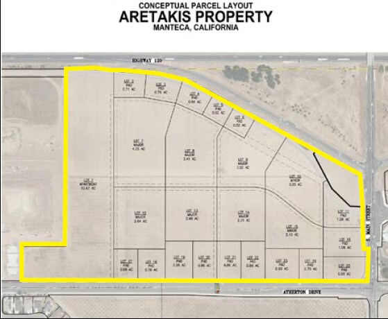
1533 S Main St, Manteca, CA 95337


Property Detail
1533 S Main St
Stockton-Lodi, CA
12-PT TO RD PER 12018027/11154209/12007955
224-021-16
SAN JOAQUIN
Orchard
California
B and X Area of moderate flood hazard, usually the area between the limits of the 100-year and 500-year floods.
44.55 AC
2025
Tracy/Manteca
2025
Stockton/Modesto
005137
NEARBY LISTINGS FOR SALE OR LEASE
DEMOGRAPHICS near 1533 S Main St
1 mile
3 mile
5 mile
2025 Total Population
13,680
86,568
118,628
2030 Population
14,427
91,568
125,177
Pop Growth 2025-2030
+ 5.46%
+ 5.78%
+ 5.52%
Average Age
38
38
39
2025 Total Households
4,121
27,191
37,316
HH Growth 2025-2030
+ 5.46%
+ 5.78%
+ 5.53%
Median Household Inc
$97,140
$93,686
$96,702
Avg Household Size
3.20
3.10
3.10
2025 Avg HH Vehicles
2.00
2.00
2.00
Median Home Value
$643,410
$630,555
$651,415
Median Year Built
1999
1993
1996
Nearby Places
Map Layers
Map Styles
 Street
 Aerial
Layers
 Traffic
 Biking
Places
Listings with unknown addresses are not visible on the map
- Restaurants
- Banks
- Shops
- Fitness
- Groceries
PUBLIC TRANSPORTATION
COMMUTER RAIL
Lathrop Station (ACE Train - Altamont Corridor Express)
Drive
Walk
Distance
Lathrop Station (ACE Train - Altamont Corridor Express)
9 min
4.5 mi
AIRPORT
Stockton Metro
Drive
Walk
Distance
Stockton Metro
18 min
10.0 mi
Freight Ports
Port of Stockton
Drive
Walk
Distance
Port of Stockton
25 min
18.9 mi
SALE & LEASE HISTORY
LISTING DATE
SALE/LEASE

Sep 17, 2019
For Sale
Mar 18, 2025
For Sale
Nearby Properties
Address
Land Use
TOTAL SIZE
Lot Size
Zoning
Address
Land Use
TOTAL SIZE
Lot Size
Zoning
510,086 SF
28.72 AC
Address
Land Use
TOTAL SIZE
Lot Size
Zoning
26,118 SF
10.80 AC
Address
Land Use
TOTAL SIZE
Lot Size
Zoning
552,450 SF
27.84 AC
Address
Land Use
TOTAL SIZE
Lot Size
Zoning
21,924 SF
9.27 AC
Address
Land Use
TOTAL SIZE
Lot Size
Zoning
350,415 SF
17.45 AC
Address
Land Use
TOTAL SIZE
Lot Size
Zoning
8,840 SF
7.51 AC
Address
Land Use
TOTAL SIZE
Lot Size
Zoning
374,976 SF
15.18 AC
Address
Land Use
TOTAL SIZE
Lot Size
Zoning
286,072 SF
19.41 AC
Address
Land Use
TOTAL SIZE
Lot Size
Zoning
106,576 SF
6.85 AC
Address
Land Use
TOTAL SIZE
Lot Size
Zoning
10,000 SF
15.18 AC
Address
Land Use
TOTAL SIZE
Lot Size
Zoning
608,500 SF
31.59 AC
Address
Land Use
TOTAL SIZE
Lot Size
Zoning
82,329 SF
5.96 AC
Address
Land Use
TOTAL SIZE
Lot Size
Zoning
175,025 SF
9.06 AC
Address
Land Use
TOTAL SIZE
Lot Size
Zoning
7.89 AC
Address
Land Use
TOTAL SIZE
Lot Size
Zoning
17.25 AC
GC
Address
Land Use
TOTAL SIZE
Lot Size
Zoning
10.05 AC
Address
Land Use
TOTAL SIZE
Lot Size
Zoning
406,580 SF
18.65 AC
Address
Land Use
TOTAL SIZE
Lot Size
Zoning
66.42 AC
AU20
Address
Land Use
TOTAL SIZE
Lot Size
Zoning
231,840 SF
11.78 AC
Address
Land Use
TOTAL SIZE
Lot Size
Zoning
161,474 SF
10.03 AC
Address
Land Use
TOTAL SIZE
Lot Size
Zoning
322,560 SF
12.85 AC
Address
Land Use
TOTAL SIZE
Lot Size
Zoning
116,872 SF
8.12 AC
Address
Land Use
TOTAL SIZE
Lot Size
Zoning
6,000 SF
3.96 AC
Address
Land Use
TOTAL SIZE
Lot Size
Zoning
16,000 SF
2 AC
Address
Land Use
TOTAL SIZE
Lot Size
Zoning
2.21 AC
Address
Land Use
TOTAL SIZE
Lot Size
Zoning
85,933 SF
3.32 AC
Address
Land Use
TOTAL SIZE
Lot Size
Zoning
2.98 AC
Address
Land Use
TOTAL SIZE
Lot Size
Zoning
37,020 SF
1.95 AC
Address
Land Use
TOTAL SIZE
Lot Size
Zoning
45,967 SF
26.19 AC
Address
Land Use
TOTAL SIZE
Lot Size
Zoning
129,117 SF
11.36 AC
The World's #1 Commercial Real Estate Marketplace
Connect with us
© 2026 CoStar Group
The information above has been obtained from sources believed reliable. While we do not doubt its accuracy we have not verified it and make no guarantee, warranty or representation about it. It is your responsibility to independently confirm its accuracy and completeness. Any projections, opinions, assumptions, or estimates used are for example only and do not represent the current or future performance of the property. The value of this transaction to you depends on tax and other factors which should be evaluated by your tax, financial, and legal advisors. You and your advisors should conduct a careful, independent investigation of the property to determine to your satisfaction the suitability of the property for your needs.