Property Record
S Pollock St, Smithfield, NC 27577

NEARBY LISTINGS FOR SALE OR LEASE
Property Detail
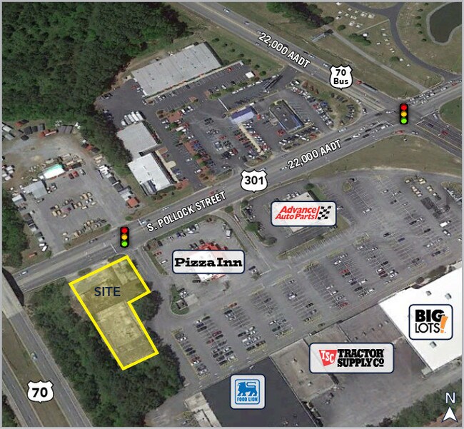
S Pollock St
14057027
OFF OF US HWY 301
Autorepair
Johnston
X
North Carolina
3720260400K
0.44 AC
2025
Johnston County
2025
Raleigh/Durham
040800
Raleigh-Cary, NC
1,676 SF
DEMOGRAPHICS near S Pollock St
1 Mile
3 Mile
5 Mile
2024 Total Population
1,827
14,937
31,118
2029 Population
2,232
18,236
37,871
Pop Growth 2024-2029
+ 22.17%
+ 22.09%
+ 21.70%
Average Age
39
39
40
2024 Total Households
729
5,695
11,688
HH Growth 2024-2029
+ 22.09%
+ 22.21%
+ 21.80%
Median Household Inc
$22,227
$24,953
$42,067
Avg Household Size
2.50
2.50
2.50
2024 Avg HH Vehicles
2.00
2.00
2.00
Median Home Value
$126,811
$162,195
$172,239
Median Year Built
1979
1978
1979
Nearby Places
Map Layers
Map Styles
 Street
 Aerial
- Restaurants
- Banks
- Shops
- Fitness
- Groceries
PUBLIC TRANSPORTATION
COMMUTER RAIL
DRIVE
WALK
Distance
4 min
1.6 mi
AIRPORT
Raleigh-Durham International
DRIVE
WALK
Distance
Raleigh-Durham International
56 min
45.5 mi
SALE & LEASE HISTORY
LISTING DATE
SALE/LEASE

Sep 25, 2016
For Lease
Sep 24, 2016
For Sale
Oct 23, 2018
For Sale
Oct 22, 2018
For Sale
Jun 04, 2018
For Lease
Jul 03, 2018
For Lease
Nearby Properties
Address
Land Use
TOTAL SIZE
Lot Size
Zoning
Address
Land Use
TOTAL SIZE
Lot Size
Zoning
59,114 SF
100.50 AC
OFF
Address
Land Use
TOTAL SIZE
Lot Size
Zoning
202,660 SF
90.41 AC
IND
Address
Land Use
TOTAL SIZE
Lot Size
Zoning
16.84 AC
OFF
Address
Land Use
TOTAL SIZE
Lot Size
Zoning
118,710 SF
34.77 AC
OFF
Address
Land Use
TOTAL SIZE
Lot Size
Zoning
158,778 SF
35.88 AC
OFF
Address
Land Use
TOTAL SIZE
Lot Size
Zoning
85,041 SF
35.02 AC
SUP
Address
Land Use
TOTAL SIZE
Lot Size
Zoning
45,000 SF
99.14 AC
IND
Address
Land Use
TOTAL SIZE
Lot Size
Zoning
71,860 SF
1.28 AC
OFF
Address
Land Use
TOTAL SIZE
Lot Size
Zoning
697,252 SF
114.71 AC
IND
Address
Land Use
TOTAL SIZE
Lot Size
Zoning
6,440 SF
16.82 AC
RES
Address
Land Use
TOTAL SIZE
Lot Size
Zoning
95,952 SF
0.34 AC
OFF
Address
Land Use
TOTAL SIZE
Lot Size
Zoning
197,722 SF
25.55 AC
COM
Address
Land Use
TOTAL SIZE
Lot Size
Zoning
79,034 SF
30 AC
OFF
Address
Land Use
TOTAL SIZE
Lot Size
Zoning
57,014 SF
15.03 AC
COM
Address
Land Use
TOTAL SIZE
Lot Size
Zoning
134,742 SF
8.20 AC
IND
Address
Land Use
TOTAL SIZE
Lot Size
Zoning
75,657 SF
15.30 AC
OFF
Address
Land Use
TOTAL SIZE
Lot Size
Zoning
24,830 SF
28.89 AC
OFF
Address
Land Use
TOTAL SIZE
Lot Size
Zoning
39,191 SF
7.46 AC
COM
Address
Land Use
TOTAL SIZE
Lot Size
Zoning
72,165 SF
24.21 AC
COM
Address
Land Use
TOTAL SIZE
Lot Size
Zoning
78,588 SF
7.99 AC
SUP
Address
Land Use
TOTAL SIZE
Lot Size
Zoning
102,276 SF
35 AC
RES
Address
Land Use
TOTAL SIZE
Lot Size
Zoning
64,134 SF
3.03 AC
COM
Address
Land Use
TOTAL SIZE
Lot Size
Zoning
120,872 SF
13.57 AC
COM
Address
Land Use
TOTAL SIZE
Lot Size
Zoning
26,980 SF
42.14 AC
OFF
Address
Land Use
TOTAL SIZE
Lot Size
Zoning
42,806 SF
1.99 AC
COM
Address
Land Use
TOTAL SIZE
Lot Size
Zoning
63,415 SF
5.45 AC
COM
Address
Land Use
TOTAL SIZE
Lot Size
Zoning
112,276 SF
10.57 AC
COM
Address
Land Use
TOTAL SIZE
Lot Size
Zoning
31,195 SF
10 AC
OFF
Address
Land Use
TOTAL SIZE
Lot Size
Zoning
50,350 SF
2.05 AC
COM
The World's #1 Commercial Real Estate Marketplace
Connect with us
© 2026 CoStar Group
The information above has been obtained from sources believed reliable. While we do not doubt its accuracy we have not verified it and make no guarantee, warranty or representation about it. It is your responsibility to independently confirm its accuracy and completeness. Any projections, opinions, assumptions, or estimates used are for example only and do not represent the current or future performance of the property. The value of this transaction to you depends on tax and other factors which should be evaluated by your tax, financial, and legal advisors. You and your advisors should conduct a careful, independent investigation of the property to determine to your satisfaction the suitability of the property for your needs.