Property Record
1438 Ga Highway 21 S, Springfield, GA 31329


NEARBY LISTINGS FOR SALE OR LEASE
Property Detail
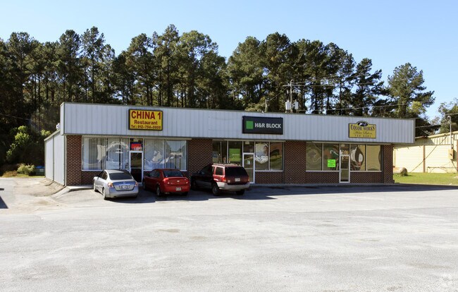
1438 Ga Highway 21 S
S1150-00000-023-000
Springfield Hwy
Officebuilding
1.29 AC RESTAURANT LANDDIST: 11
X
Effingham
13103C0256E
Georgia
2025
1.29 AC
2025
Effingham County
030209
Savannah
3,312 SF
Savannah, GA
DEMOGRAPHICS near 1438 Ga Highway 21 S
1 Mile
3 Mile
5 Mile
2024 Total Population
871
8,764
16,915
2029 Population
1,023
10,218
19,771
Pop Growth 2024-2029
+ 17.45%
+ 16.59%
+ 16.88%
Average Age
35
37
37
2024 Total Households
301
2,994
5,861
HH Growth 2024-2029
+ 17.28%
+ 16.57%
+ 16.86%
Median Household Inc
$67,678
$66,485
$72,140
Avg Household Size
2.90
2.90
2.80
2024 Avg HH Vehicles
2.00
2.00
2.00
Median Home Value
$221,212
$221,388
$234,204
Median Year Built
2004
2000
2000
Nearby Places
Map Layers
Map Styles
 Street
 Aerial
- Restaurants
- Banks
- Shops
- Fitness
- Groceries
PUBLIC TRANSPORTATION
AIRPORT
Savannah/Hilton Head International
DRIVE
WALK
Distance
Savannah/Hilton Head International
32 min
21.8 mi
Freight Ports
Georgia Ports - Savannah
DRIVE
WALK
Distance
Georgia Ports - Savannah
27 min
20.2 mi
SALE & LEASE HISTORY
LISTING DATE
SALE/LEASE

Sep 25, 2016
For Lease
Nearby Properties
Address
Land Use
TOTAL SIZE
Lot Size
Zoning
Address
Land Use
TOTAL SIZE
Lot Size
Zoning
258,754 SF
43.46 AC
I-1
Address
Land Use
TOTAL SIZE
Lot Size
Zoning
6,914 SF
11.15 AC
B-1
Address
Land Use
TOTAL SIZE
Lot Size
Zoning
52,779 SF
0.82 AC
B-2
Address
Land Use
TOTAL SIZE
Lot Size
Zoning
241,200 SF
30.97 AC
I-1
Address
Land Use
TOTAL SIZE
Lot Size
Zoning
61,475 SF
60.87 AC
I-1
Address
Land Use
TOTAL SIZE
Lot Size
Zoning
162,400 SF
8.41 AC
I-1
Address
Land Use
TOTAL SIZE
Lot Size
Zoning
10,118 SF
16.75 AC
R-3
Address
Land Use
TOTAL SIZE
Lot Size
Zoning
6,720 SF
87.16 AC
I-1
Address
Land Use
TOTAL SIZE
Lot Size
Zoning
42,403 SF
30 AC
AR-1
Address
Land Use
TOTAL SIZE
Lot Size
Zoning
21,445 SF
1.60 AC
B-2
Address
Land Use
TOTAL SIZE
Lot Size
Zoning
10,200 SF
6.92 AC
B-1
Address
Land Use
TOTAL SIZE
Lot Size
Zoning
15,088 SF
11.31 AC
B-3
Address
Land Use
TOTAL SIZE
Lot Size
Zoning
102,010 SF
5.94 AC
I-1
Address
Land Use
TOTAL SIZE
Lot Size
Zoning
97,800 SF
6.72 AC
I-1
Address
Land Use
TOTAL SIZE
Lot Size
Zoning
14,472 SF
2.27 AC
B-1
Address
Land Use
TOTAL SIZE
Lot Size
Zoning
30,400 SF
3.17 AC
I-1
Address
Land Use
TOTAL SIZE
Lot Size
Zoning
5,400 SF
11.29 AC
I-1
Address
Land Use
TOTAL SIZE
Lot Size
Zoning
25,920 SF
77.47 AC
I-1
Address
Land Use
TOTAL SIZE
Lot Size
Zoning
55,200 SF
9.04 AC
I-1
Address
Land Use
TOTAL SIZE
Lot Size
Zoning
51,356 SF
4.73 AC
I-1
Address
Land Use
TOTAL SIZE
Lot Size
Zoning
27,762 SF
1.45 AC
R-1
Address
Land Use
TOTAL SIZE
Lot Size
Zoning
10,872 SF
5 AC
I-1
Address
Land Use
TOTAL SIZE
Lot Size
Zoning
53,184 SF
5 AC
I-1
Address
Land Use
TOTAL SIZE
Lot Size
Zoning
45,627 SF
5 AC
I-1
Address
Land Use
TOTAL SIZE
Lot Size
Zoning
5,066 SF
2.67 AC
B-1
Address
Land Use
TOTAL SIZE
Lot Size
Zoning
10,857 SF
1.45 AC
B-1
Address
Land Use
TOTAL SIZE
Lot Size
Zoning
13,902 SF
3.85 AC
I-1
Address
Land Use
TOTAL SIZE
Lot Size
Zoning
20,776 SF
0.92 AC
R-1
Address
Land Use
TOTAL SIZE
Lot Size
Zoning
11,036 SF
6.15 AC
R-1
Address
Land Use
TOTAL SIZE
Lot Size
Zoning
17,855 SF
1.16 AC
B-2
The World's #1 Commercial Real Estate Marketplace
Connect with us
© 2025 CoStar Group
The information above has been obtained from sources believed reliable. While we do not doubt its accuracy we have not verified it and make no guarantee, warranty or representation about it. It is your responsibility to independently confirm its accuracy and completeness. Any projections, opinions, assumptions, or estimates used are for example only and do not represent the current or future performance of the property. The value of this transaction to you depends on tax and other factors which should be evaluated by your tax, financial, and legal advisors. You and your advisors should conduct a careful, independent investigation of the property to determine to your satisfaction the suitability of the property for your needs.