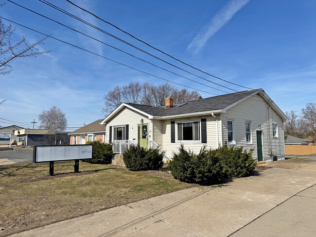
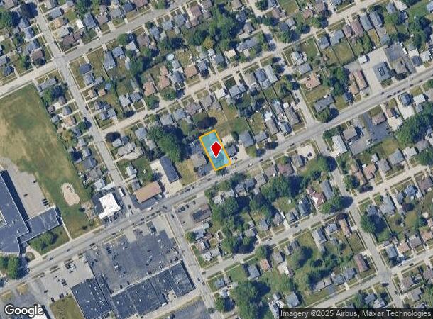
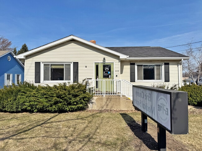
Property Record
1438 W 38Th St, Erie, PA 16508
Current Lease Availabilities
NEARBY LISTINGS FOR SALE OR LEASE
Property Detail
1438 W 38Th St
19-061-037.0-118.00
1438 W 38 ST 67.5 X 150.9 AV
Commercialofficeresidentialmixeduse
Erie
X
Pennsylvania
42049C0203D
0.23 AC
2025
Greater Erie
2025
Erie
002200
Erie, PA
2,574 SF
DEMOGRAPHICS near 1438 W 38Th St
1 Mile
3 Mile
5 Mile
2024 Total Population
16,778
95,536
149,997
2029 Population
16,510
94,725
148,446
Pop Growth 2024-2029
(1.60%)
(0.85%)
(1.03%)
Average Age
41
40
41
2024 Total Households
7,435
40,609
62,933
HH Growth 2024-2029
(1.80%)
(0.94%)
(1.13%)
Median Household Inc
$58,103
$49,073
$51,765
Avg Household Size
2.20
2.20
2.20
2024 Avg HH Vehicles
2.00
1.00
1.00
Median Home Value
$122,827
$131,571
$137,653
Median Year Built
1955
1955
1958
Nearby Places
Map Layers
Map Styles
 Street
 Aerial
- Restaurants
- Banks
- Shops
- Fitness
- Groceries
PUBLIC TRANSPORTATION
COMMUTER RAIL
Erie Amtrak Station (Lake Shore Limited - Amtrak)
DRIVE
WALK
Distance
Erie Amtrak Station (Lake Shore Limited - Amtrak)
7 min
2.8 mi
AIRPORT
Erie International/Tom Ridge Field
DRIVE
WALK
Distance
Erie International/Tom Ridge Field
12 min
5.7 mi
Freight Ports
Port of Toledo
DRIVE
WALK
Distance
Port of Toledo
251 min
212.4 mi
Nearby Properties
Address
Land Use
TOTAL SIZE
Lot Size
Zoning
Address
Land Use
TOTAL SIZE
Lot Size
Zoning
35,529 SF
84.04 AC
BB
Address
Land Use
TOTAL SIZE
Lot Size
Zoning
31,764 SF
46.83 AC
R3
Address
Land Use
TOTAL SIZE
Lot Size
Zoning
2.73 AC
C3
Address
Land Use
TOTAL SIZE
Lot Size
Zoning
630,344 SF
7.57 AC
RLB
Address
Land Use
TOTAL SIZE
Lot Size
Zoning
5 AC
RLB
Address
Land Use
TOTAL SIZE
Lot Size
Zoning
3.38 AC
RLB
Address
Land Use
TOTAL SIZE
Lot Size
Zoning
189,344 SF
2.14 AC
C3
Address
Land Use
TOTAL SIZE
Lot Size
Zoning
800 SF
10.05 AC
R2
Address
Land Use
TOTAL SIZE
Lot Size
Zoning
14,688 SF
39.53 AC
AR
Address
Land Use
TOTAL SIZE
Lot Size
Zoning
108,080 SF
4.83 AC
AR
Address
Land Use
TOTAL SIZE
Lot Size
Zoning
375,929 SF
5.02 AC
C3
Address
Land Use
TOTAL SIZE
Lot Size
Zoning
10,960 SF
29.82 AC
DR
Address
Land Use
TOTAL SIZE
Lot Size
Zoning
22.02 AC
AR
Address
Land Use
TOTAL SIZE
Lot Size
Zoning
227,718 SF
47.43 AC
DB
Address
Land Use
TOTAL SIZE
Lot Size
Zoning
1.56 AC
C3
Address
Land Use
TOTAL SIZE
Lot Size
Zoning
170,870 SF
4.51 AC
RLB
Address
Land Use
TOTAL SIZE
Lot Size
Zoning
117,879 SF
13.47 AC
M1
Address
Land Use
TOTAL SIZE
Lot Size
Zoning
2.45 AC
RLB
Address
Land Use
TOTAL SIZE
Lot Size
Zoning
171,306 SF
6.30 AC
AR
Address
Land Use
TOTAL SIZE
Lot Size
Zoning
127,756 SF
7.21 AC
RLB
Address
Land Use
TOTAL SIZE
Lot Size
Zoning
2,754 SF
26.83 AC
DB
Address
Land Use
TOTAL SIZE
Lot Size
Zoning
198,102 SF
27.63 AC
B1
Address
Land Use
TOTAL SIZE
Lot Size
Zoning
80,390 SF
69.53 AC
B1
Address
Land Use
TOTAL SIZE
Lot Size
Zoning
171,966 SF
13.99 AC
RB
Address
Land Use
TOTAL SIZE
Lot Size
Zoning
3,340 SF
37.04 AC
AR
Address
Land Use
TOTAL SIZE
Lot Size
Zoning
163,596 SF
14.31 AC
C2
Address
Land Use
TOTAL SIZE
Lot Size
Zoning
0.66 AC
C3
Address
Land Use
TOTAL SIZE
Lot Size
Zoning
38 AC
AR
Address
Land Use
TOTAL SIZE
Lot Size
Zoning
178,236 SF
26.15 AC
RLB
Address
Land Use
TOTAL SIZE
Lot Size
Zoning
10.62 AC
R2
The World's #1 Commercial Real Estate Marketplace
Connect with us
© 2025 CoStar Group
The information above has been obtained from sources believed reliable. While we do not doubt its accuracy we have not verified it and make no guarantee, warranty or representation about it. It is your responsibility to independently confirm its accuracy and completeness. Any projections, opinions, assumptions, or estimates used are for example only and do not represent the current or future performance of the property. The value of this transaction to you depends on tax and other factors which should be evaluated by your tax, financial, and legal advisors. You and your advisors should conduct a careful, independent investigation of the property to determine to your satisfaction the suitability of the property for your needs.