Property Record
14384 W Freeway Dr Ne, Columbus, MN 55025
NEARBY LISTINGS FOR SALE OR LEASE
-
-
-
-
6015 190th Street North (NWQ of HW 61 and 190th St
Forest Lake, MN 55025
$1,200,000
24.50 AC Lots
Land
-
-
-
View all Columbus listings for sale on LoopNet.com
Property Detail
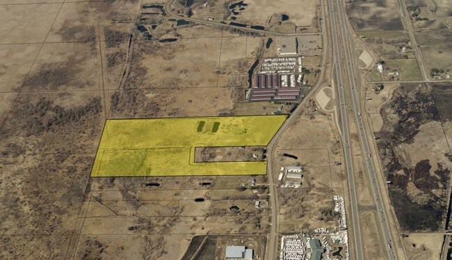
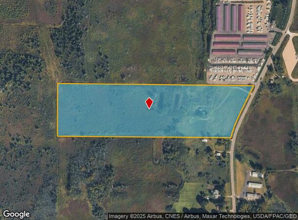
14384 W Freeway Dr Ne
25-32-22-32-0003
THAT PRT OF S 1/2 OF N 1/2 OF SW 1/4 LYG W OF C/L OF CSAH #21 & N OF A LINE RUN PRLL/W & 1395 FT N OF S LINE IF SD SW 1/4 AS MEAS OF RT ANG TO S S LINE EX RD& SUBJ TO EASE OF REC
Agriculturalland
Anoka
X
Minnesota
27003C0360E
26.62 AC
2025
Anoka County Outlying
2025
Minneapolis/St Paul
070103
Minneapolis-St. Paul-Bloomington, MN-WI
DEMOGRAPHICS near 14384 W Freeway Dr Ne
1 Mile
3 Mile
5 Mile
2024 Total Population
144
5,637
34,787
2029 Population
145
6,034
37,278
Pop Growth 2024-2029
+ 0.69%
+ 7.04%
+ 7.16%
Average Age
44
39
39
2024 Total Households
56
2,076
13,417
HH Growth 2024-2029
0.00%
+ 7.13%
+ 7.36%
Median Household Inc
$98,863
$93,454
$94,727
Avg Household Size
2.50
2.70
2.60
2024 Avg HH Vehicles
3.00
2.00
2.00
Median Home Value
$368,181
$402,177
$346,738
Median Year Built
1980
2001
1996
Nearby Places
Map Layers
Map Styles
 Street
 Aerial
- Restaurants
- Banks
- Shops
- Fitness
- Groceries
PUBLIC TRANSPORTATION
AIRPORT
Minneapolis-St Paul International/Wold-Chamberlain
DRIVE
WALK
Distance
Minneapolis-St Paul International/Wold-Chamberlain
45 min
33.5 mi
Freight Ports
Port Milwaukee
DRIVE
WALK
Distance
Port Milwaukee
387 min
350.0 mi
SALE & LEASE HISTORY
LISTING DATE
SALE/LEASE

Dec 05, 2018
For Sale
Nearby Properties
Address
Land Use
TOTAL SIZE
Lot Size
Zoning
Address
Land Use
TOTAL SIZE
Lot Size
Zoning
39,032 SF
12.34 AC
Address
Land Use
TOTAL SIZE
Lot Size
Zoning
54,507 SF
8.63 AC
Address
Land Use
TOTAL SIZE
Lot Size
Zoning
103,200 SF
13.20 AC
Address
Land Use
TOTAL SIZE
Lot Size
Zoning
86,423 SF
82.84 AC
Address
Land Use
TOTAL SIZE
Lot Size
Zoning
71,450 SF
Address
Land Use
TOTAL SIZE
Lot Size
Zoning
66,155 SF
6.51 AC
Address
Land Use
TOTAL SIZE
Lot Size
Zoning
114,251 SF
7.58 AC
Address
Land Use
TOTAL SIZE
Lot Size
Zoning
1,052 SF
140.60 AC
Address
Land Use
TOTAL SIZE
Lot Size
Zoning
81,248 SF
1.07 AC
Address
Land Use
TOTAL SIZE
Lot Size
Zoning
67,616 SF
Address
Land Use
TOTAL SIZE
Lot Size
Zoning
95,384 SF
13.40 AC
Address
Land Use
TOTAL SIZE
Lot Size
Zoning
56,120 SF
3.44 AC
Address
Land Use
TOTAL SIZE
Lot Size
Zoning
51,860 SF
78.12 AC
Address
Land Use
TOTAL SIZE
Lot Size
Zoning
15,850 SF
23.79 AC
Address
Land Use
TOTAL SIZE
Lot Size
Zoning
45,576 SF
Address
Land Use
TOTAL SIZE
Lot Size
Zoning
1,144 SF
39 AC
Address
Land Use
TOTAL SIZE
Lot Size
Zoning
49,224 SF
2.50 AC
Address
Land Use
TOTAL SIZE
Lot Size
Zoning
49,224 SF
2.32 AC
Address
Land Use
TOTAL SIZE
Lot Size
Zoning
3,600 SF
67.80 AC
Address
Land Use
TOTAL SIZE
Lot Size
Zoning
2,130 SF
25.48 AC
Address
Land Use
TOTAL SIZE
Lot Size
Zoning
20,711 SF
Address
Land Use
TOTAL SIZE
Lot Size
Zoning
764 SF
4.10 AC
Address
Land Use
TOTAL SIZE
Lot Size
Zoning
37.88 AC
Address
Land Use
TOTAL SIZE
Lot Size
Zoning
33,740 SF
32 AC
Address
Land Use
TOTAL SIZE
Lot Size
Zoning
21,000 SF
Address
Land Use
TOTAL SIZE
Lot Size
Zoning
2,911 SF
31.05 AC
Address
Land Use
TOTAL SIZE
Lot Size
Zoning
21,748 SF
27.40 AC
Address
Land Use
TOTAL SIZE
Lot Size
Zoning
3,080 SF
Address
Land Use
TOTAL SIZE
Lot Size
Zoning
34,885 SF
3.57 AC
The World's #1 Commercial Real Estate Marketplace
Connect with us
© 2025 CoStar Group
The information above has been obtained from sources believed reliable. While we do not doubt its accuracy we have not verified it and make no guarantee, warranty or representation about it. It is your responsibility to independently confirm its accuracy and completeness. Any projections, opinions, assumptions, or estimates used are for example only and do not represent the current or future performance of the property. The value of this transaction to you depends on tax and other factors which should be evaluated by your tax, financial, and legal advisors. You and your advisors should conduct a careful, independent investigation of the property to determine to your satisfaction the suitability of the property for your needs.