Property Record
14388 Nw Highway 19, Chiefland, FL 32626
NEARBY LISTINGS FOR SALE OR LEASE
Property Detail
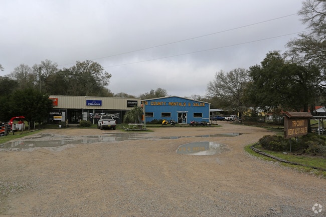
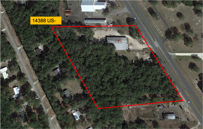
14388 Nw Highway 19
07541-030-00
Us 19 Add 2
Vehiclerentalsvehiclesales
10-11-14 US 19 NO 2 ADD BLK 2 LOT 46 OR BOOK 1701 PAGES 813, 823 OR BOOK 1782 PAGE 996
X
Levy
12075C0020F
Florida
2024
46
2025
2.34 AC
9703023101
Florida Central North Area
13,100 SF
Other Market Areas
DEMOGRAPHICS near 14388 Nw Highway 19
1 Mile
3 Mile
5 Mile
2024 Total Population
810
4,183
10,484
2029 Population
907
4,740
11,824
Pop Growth 2024-2029
+ 11.98%
+ 13.32%
+ 12.78%
Average Age
45
45
44
2024 Total Households
351
1,761
4,302
HH Growth 2024-2029
+ 11.97%
+ 13.29%
+ 12.72%
Median Household Inc
$33,683
$32,546
$34,687
Avg Household Size
2.30
2.40
2.40
2024 Avg HH Vehicles
2.00
2.00
2.00
Median Home Value
$149,404
$110,311
$119,626
Median Year Built
1992
1993
1990
Nearby Places
Map Layers
Map Styles
 Street
 Aerial
- Restaurants
- Banks
- Shops
- Fitness
- Groceries
SALE & LEASE HISTORY
LISTING DATE
SALE/LEASE

Jul 09, 2022
For Sale
Nearby Properties
Address
Land Use
TOTAL SIZE
Lot Size
Zoning
Address
Land Use
TOTAL SIZE
Lot Size
Zoning
187,099 SF
21 AC
Address
Land Use
TOTAL SIZE
Lot Size
Zoning
43,619 SF
4.37 AC
Address
Land Use
TOTAL SIZE
Lot Size
Zoning
14,855 SF
1.70 AC
Address
Land Use
TOTAL SIZE
Lot Size
Zoning
36,685 SF
3.49 AC
Address
Land Use
TOTAL SIZE
Lot Size
Zoning
13,050 SF
1.66 AC
Address
Land Use
TOTAL SIZE
Lot Size
Zoning
54,084 SF
8.80 AC
0
Address
Land Use
TOTAL SIZE
Lot Size
Zoning
18,506 SF
3 AC
Address
Land Use
TOTAL SIZE
Lot Size
Zoning
5,900 SF
22.72 AC
Address
Land Use
TOTAL SIZE
Lot Size
Zoning
8,144 SF
41.18 AC
Address
Land Use
TOTAL SIZE
Lot Size
Zoning
5,000 SF
4.37 AC
Address
Land Use
TOTAL SIZE
Lot Size
Zoning
3,860 SF
1.20 AC
Address
Land Use
TOTAL SIZE
Lot Size
Zoning
12,141 SF
4.63 AC
Address
Land Use
TOTAL SIZE
Lot Size
Zoning
21,550 SF
4.13 AC
Address
Land Use
TOTAL SIZE
Lot Size
Zoning
8,284 SF
2 AC
Address
Land Use
TOTAL SIZE
Lot Size
Zoning
2,970 SF
1.32 AC
Address
Land Use
TOTAL SIZE
Lot Size
Zoning
4,320 SF
3.60 AC
Address
Land Use
TOTAL SIZE
Lot Size
Zoning
15,886 SF
2.67 AC
Address
Land Use
TOTAL SIZE
Lot Size
Zoning
6,882 SF
10.08 AC
Address
Land Use
TOTAL SIZE
Lot Size
Zoning
33,434 SF
4.41 AC
Address
Land Use
TOTAL SIZE
Lot Size
Zoning
13,003 SF
2.41 AC
Address
Land Use
TOTAL SIZE
Lot Size
Zoning
16,425 SF
4.37 AC
Address
Land Use
TOTAL SIZE
Lot Size
Zoning
2,936 SF
2.48 AC
Address
Land Use
TOTAL SIZE
Lot Size
Zoning
5,170 SF
0.60 AC
Address
Land Use
TOTAL SIZE
Lot Size
Zoning
6,400 SF
1.45 AC
Address
Land Use
TOTAL SIZE
Lot Size
Zoning
11,504 SF
4.69 AC
Address
Land Use
TOTAL SIZE
Lot Size
Zoning
2,880 SF
0.50 AC
Address
Land Use
TOTAL SIZE
Lot Size
Zoning
6,000 SF
1.76 AC
Address
Land Use
TOTAL SIZE
Lot Size
Zoning
5,040 SF
2 AC
Address
Land Use
TOTAL SIZE
Lot Size
Zoning
8,460 SF
5.10 AC
The World's #1 Commercial Real Estate Marketplace
Connect with us
© 2026 CoStar Group
The information above has been obtained from sources believed reliable. While we do not doubt its accuracy we have not verified it and make no guarantee, warranty or representation about it. It is your responsibility to independently confirm its accuracy and completeness. Any projections, opinions, assumptions, or estimates used are for example only and do not represent the current or future performance of the property. The value of this transaction to you depends on tax and other factors which should be evaluated by your tax, financial, and legal advisors. You and your advisors should conduct a careful, independent investigation of the property to determine to your satisfaction the suitability of the property for your needs.