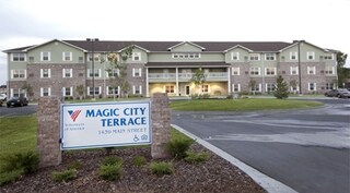
Property Record
1439 Main St, Billings, MT 59105

NEARBY LISTINGS FOR SALE OR LEASE
-
-
View all Billings listings for sale on LoopNet.com
Property Detail
1439 Main St
03-1033-22-1-12-02-0000
Certificate/Surv 1781 02
Commercialnec
S22, T01 N, R26 E, C.O.S. 1781, PARCEL 2
X
Yellowstone
30111C1280E
Montana
2024
4.12 AC
2025
Other Market Areas
000706
Billings, MT
72,949 SF
DEMOGRAPHICS near 1439 Main St
1 Mile
3 Mile
5 Mile
2024 Total Population
11,393
38,444
72,963
2029 Population
12,380
41,719
78,773
Pop Growth 2024-2029
+ 8.66%
+ 8.52%
+ 7.96%
Average Age
39
39
39
2024 Total Households
4,810
15,335
30,029
HH Growth 2024-2029
+ 8.88%
+ 8.66%
+ 8.11%
Median Household Inc
$60,860
$68,511
$66,080
Avg Household Size
2.30
2.40
2.30
2024 Avg HH Vehicles
2.00
2.00
2.00
Median Home Value
$244,963
$275,697
$277,857
Median Year Built
1989
1986
1975
Nearby Places
Map Layers
Map Styles
 Street
 Aerial
- Restaurants
- Banks
- Shops
- Fitness
- Groceries
PUBLIC TRANSPORTATION
AIRPORT
Billings Logan International
DRIVE
WALK
Distance
Billings Logan International
23 min
8.0 mi
Freight Ports
Port of Everett
DRIVE
WALK
Distance
Port of Everett
891 min
845.2 mi
Nearby Properties
Address
Land Use
TOTAL SIZE
Lot Size
Zoning
Address
Land Use
TOTAL SIZE
Lot Size
Zoning
240,253 SF
282.66 AC
HI
Address
Land Use
TOTAL SIZE
Lot Size
Zoning
6,000 SF
152.47 AC
PUBLIC-COU
Address
Land Use
TOTAL SIZE
Lot Size
Zoning
228,269 SF
44.60 AC
PUBLIC-CIT
Address
Land Use
TOTAL SIZE
Lot Size
Zoning
117,130 SF
29.86 AC
R-70
Address
Land Use
TOTAL SIZE
Lot Size
Zoning
141,056 SF
25.82 AC
PUBLIC-CIT
Address
Land Use
TOTAL SIZE
Lot Size
Zoning
181,007 SF
19.57 AC
Address
Land Use
TOTAL SIZE
Lot Size
Zoning
125,400 SF
2.41 AC
CI
Address
Land Use
TOTAL SIZE
Lot Size
Zoning
78,328 SF
7.78 AC
R9600-CITY
Address
Land Use
TOTAL SIZE
Lot Size
Zoning
68,022 SF
4.01 AC
CI
Address
Land Use
TOTAL SIZE
Lot Size
Zoning
53.34 AC
P
Address
Land Use
TOTAL SIZE
Lot Size
Zoning
57,112 SF
7.69 AC
Address
Land Use
TOTAL SIZE
Lot Size
Zoning
25,045 SF
10.77 AC
R-70
Address
Land Use
TOTAL SIZE
Lot Size
Zoning
43.08 AC
R-96
Address
Land Use
TOTAL SIZE
Lot Size
Zoning
41.37 AC
P
Address
Land Use
TOTAL SIZE
Lot Size
Zoning
128,015 SF
17.89 AC
CI
Address
Land Use
TOTAL SIZE
Lot Size
Zoning
36,786 SF
11.50 AC
R9600-CITY
Address
Land Use
TOTAL SIZE
Lot Size
Zoning
46,680 SF
11.18 AC
R-96
Address
Land Use
TOTAL SIZE
Lot Size
Zoning
42,704 SF
8.56 AC
R-70
Address
Land Use
TOTAL SIZE
Lot Size
Zoning
48,217 SF
9.99 AC
R-96
Address
Land Use
TOTAL SIZE
Lot Size
Zoning
60,615 SF
4.25 AC
R-70
Address
Land Use
TOTAL SIZE
Lot Size
Zoning
20,266 SF
3.91 AC
RMF
Address
Land Use
TOTAL SIZE
Lot Size
Zoning
21,162 SF
3.83 AC
RMF
Address
Land Use
TOTAL SIZE
Lot Size
Zoning
67,301 SF
3.65 AC
RMF-R
Address
Land Use
TOTAL SIZE
Lot Size
Zoning
125,591 SF
12 AC
HC
Address
Land Use
TOTAL SIZE
Lot Size
Zoning
42,176 SF
21.63 AC
PUBLIC-CIT
Address
Land Use
TOTAL SIZE
Lot Size
Zoning
104,596 SF
10.32 AC
HI
Address
Land Use
TOTAL SIZE
Lot Size
Zoning
22,574 SF
23.53 AC
CI
Address
Land Use
TOTAL SIZE
Lot Size
Zoning
65,662 SF
41.39 AC
Address
Land Use
TOTAL SIZE
Lot Size
Zoning
42.39 AC
RMH
The World's #1 Commercial Real Estate Marketplace
Connect with us
© 2026 CoStar Group
The information above has been obtained from sources believed reliable. While we do not doubt its accuracy we have not verified it and make no guarantee, warranty or representation about it. It is your responsibility to independently confirm its accuracy and completeness. Any projections, opinions, assumptions, or estimates used are for example only and do not represent the current or future performance of the property. The value of this transaction to you depends on tax and other factors which should be evaluated by your tax, financial, and legal advisors. You and your advisors should conduct a careful, independent investigation of the property to determine to your satisfaction the suitability of the property for your needs.