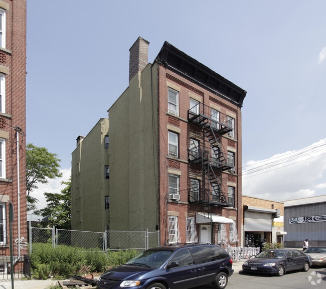
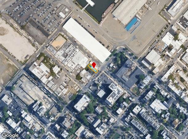
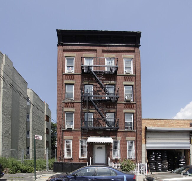
Property Record
144 Conover St, Brooklyn, NY 11231
NEARBY LISTINGS FOR SALE OR LEASE
Property Detail
144 Conover St
00554-0028
DOCID-2013010700501001
Multifamilydwelling
Kings
AE
New York
3604970192F
28
2024
0.06 AC
2025
Red Hook
005301
Long Island (New York)
5,872 SF
New York-Jersey City-White Plains, NY-NJ
DEMOGRAPHICS near 144 Conover St
1 Mile
3 Mile
5 Mile
2024 Total Population
31,130
617,283
2,427,018
2029 Population
29,527
581,209
2,289,990
Pop Growth 2024-2029
(5.15%)
(5.84%)
(5.65%)
Average Age
38
38
38
2024 Total Households
13,067
259,466
989,985
HH Growth 2024-2029
(5.66%)
(5.92%)
(5.92%)
Median Household Inc
$107,988
$107,908
$85,157
Avg Household Size
2.30
2.30
2.30
2024 Avg HH Vehicles
.00
.00
.00
Median Home Value
$1,093,799
$1,025,832
$901,011
Median Year Built
1947
1948
1948
Nearby Places
Map Layers
Map Styles
 Street
 Aerial
- Restaurants
- Banks
- Shops
- Fitness
- Groceries
PUBLIC TRANSPORTATION
TRANSIT/SUBWAY
Smith-9 Streets (F - New York MTA Subway (The Subway), G - New York MTA Subway (The Subway))
DRIVE
WALK
Distance
Smith-9 Streets (F - New York MTA Subway (The Subway), G - New York MTA Subway (The Subway))
4 min
20 min
1.0 mi
COMMUTER RAIL
DRIVE
WALK
Distance
9 min
2.9 mi
Nostrand Avenue Station (Far Rockaway Branch - Long Island Rail Road, Hempstead Branch - Long Island Rail Road, Long Beach Branch - Long Island Rail Road, West Hempstead Branch - Long Island Rail Road)
DRIVE
WALK
Distance
Nostrand Avenue Station (Far Rockaway Branch - Long Island Rail Road, Hempstead Branch - Long Island Rail Road, Long Beach Branch - Long Island Rail Road, West Hempstead Branch - Long Island Rail Road)
13 min
4.3 mi
AIRPORT
LaGuardia
DRIVE
WALK
Distance
LaGuardia
23 min
12.5 mi
John F Kennedy International
DRIVE
WALK
Distance
John F Kennedy International
30 min
15.8 mi
Newark Liberty International
DRIVE
WALK
Distance
Newark Liberty International
28 min
16.1 mi
Freight Ports
NY - Red Hook Container Terminal
DRIVE
WALK
Distance
NY - Red Hook Container Terminal
2 min
0.8 mi
Nearby Properties
Address
Land Use
TOTAL SIZE
Lot Size
Zoning
Address
Land Use
TOTAL SIZE
Lot Size
Zoning
2,354,289 SF
3.96 AC
C6-4
Address
Land Use
TOTAL SIZE
Lot Size
Zoning
2.38 AC
Address
Land Use
TOTAL SIZE
Lot Size
Zoning
1.75 AC
Address
Land Use
TOTAL SIZE
Lot Size
Zoning
2,157,862 SF
2.23 AC
BPC
Address
Land Use
TOTAL SIZE
Lot Size
Zoning
229.72 AC
Address
Land Use
TOTAL SIZE
Lot Size
Zoning
2,255,659 SF
4.58 AC
BPC
Address
Land Use
TOTAL SIZE
Lot Size
Zoning
Address
Land Use
TOTAL SIZE
Lot Size
Zoning
6.42 AC
Address
Land Use
TOTAL SIZE
Lot Size
Zoning
2,233,692 SF
1.90 AC
BPC
Address
Land Use
TOTAL SIZE
Lot Size
Zoning
2.21 AC
Address
Land Use
TOTAL SIZE
Lot Size
Zoning
1,636,000 SF
1.09 AC
C6-4
Address
Land Use
TOTAL SIZE
Lot Size
Zoning
1,909,502 SF
2.37 AC
BPC
Address
Land Use
TOTAL SIZE
Lot Size
Zoning
1,780,030 SF
5.07 AC
BPC
Address
Land Use
TOTAL SIZE
Lot Size
Zoning
7,058,736 SF
147.61 AC
M3-1
Address
Land Use
TOTAL SIZE
Lot Size
Zoning
869,038 SF
1.53 AC
M1-1
Address
Land Use
TOTAL SIZE
Lot Size
Zoning
1.04 AC
Address
Land Use
TOTAL SIZE
Lot Size
Zoning
1.84 AC
Address
Land Use
TOTAL SIZE
Lot Size
Zoning
92,440 SF
466.23 AC
R5
Address
Land Use
TOTAL SIZE
Lot Size
Zoning
802,000 SF
1.20 AC
C62A
Address
Land Use
TOTAL SIZE
Lot Size
Zoning
2,210,200 SF
2.58 AC
C5-5
Address
Land Use
TOTAL SIZE
Lot Size
Zoning
1,362,190 SF
C5-5
Address
Land Use
TOTAL SIZE
Lot Size
Zoning
1,653,794 SF
3.15 AC
C6-4
Address
Land Use
TOTAL SIZE
Lot Size
Zoning
0.66 AC
Address
Land Use
TOTAL SIZE
Lot Size
Zoning
932,587 SF
1.23 AC
C5-3
Address
Land Use
TOTAL SIZE
Lot Size
Zoning
1,499,568 SF
1.66 AC
C5-5
Address
Land Use
TOTAL SIZE
Lot Size
Zoning
Address
Land Use
TOTAL SIZE
Lot Size
Zoning
1,440,960 SF
2.17 AC
BPC
Address
Land Use
TOTAL SIZE
Lot Size
Zoning
1,740,736 SF
4.29 AC
C6-4
Address
Land Use
TOTAL SIZE
Lot Size
Zoning
1,617,206 SF
1.23 AC
C5-5
Address
Land Use
TOTAL SIZE
Lot Size
Zoning
2,542,066 SF
174.49 AC
R3-2
The World's #1 Commercial Real Estate Marketplace
Connect with us
© 2026 CoStar Group
The information above has been obtained from sources believed reliable. While we do not doubt its accuracy we have not verified it and make no guarantee, warranty or representation about it. It is your responsibility to independently confirm its accuracy and completeness. Any projections, opinions, assumptions, or estimates used are for example only and do not represent the current or future performance of the property. The value of this transaction to you depends on tax and other factors which should be evaluated by your tax, financial, and legal advisors. You and your advisors should conduct a careful, independent investigation of the property to determine to your satisfaction the suitability of the property for your needs.