Property Record
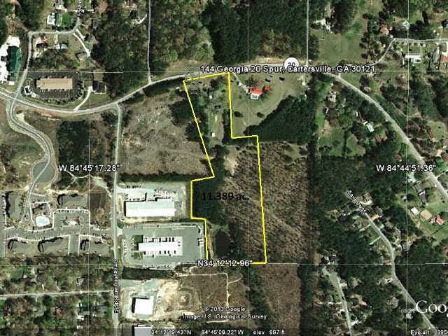
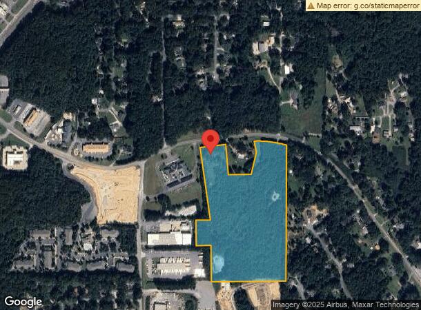
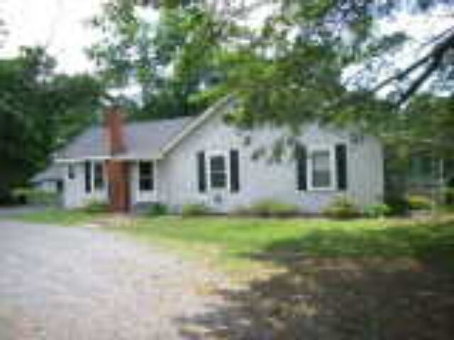
144 State Route 20 Spur Se, Cartersville, GA 30121
NEARBY LISTINGS FOR SALE OR LEASE
Property Detail
144 State Route 20 Spur Se
Atlanta-Sandy Springs-Roswell, GA
Com - Hwy 20
0091-0040-005
LL40 LD4 TRACT 1& P/O 2 PLAT 70-82
Commercialacreage
Bartow
X
Georgia
13015C0259H
tract 1
2024
21.03 AC
2024
Bartow County
960403
Atlanta
2,064 SF
DEMOGRAPHICS near 144 State Route 20 Spur Se
1 Mile
3 Mile
5 Mile
2024 Total Population
2,095
13,667
41,728
2029 Population
2,249
14,910
45,593
Pop Growth 2024-2029
+ 7.35%
+ 9.09%
+ 9.26%
Average Age
39
39
39
2024 Total Households
835
5,057
15,969
HH Growth 2024-2029
+ 6.95%
+ 8.86%
+ 9.02%
Median Household Inc
$79,706
$67,275
$68,278
Avg Household Size
2.50
2.50
2.50
2024 Avg HH Vehicles
2.00
2.00
2.00
Median Home Value
$216,667
$230,971
$228,330
Median Year Built
1992
1995
1992
Nearby Places
- Restaurants
- Banks
- Shops
- Fitness
- Groceries
Nearby Properties
Address
Land Use
TOTAL SIZE
Lot Size
Zoning
Address
Land Use
TOTAL SIZE
Lot Size
Zoning
141,651 SF
181.89 AC
I1
Address
Land Use
TOTAL SIZE
Lot Size
Zoning
7,488 SF
38.49 AC
IN
Address
Land Use
TOTAL SIZE
Lot Size
Zoning
342,088 SF
49.67 AC
Address
Land Use
TOTAL SIZE
Lot Size
Zoning
107,992 SF
46 AC
IN
Address
Land Use
TOTAL SIZE
Lot Size
Zoning
67,428 SF
36.96 AC
Address
Land Use
TOTAL SIZE
Lot Size
Zoning
250,701 SF
15.17 AC
C1
Address
Land Use
TOTAL SIZE
Lot Size
Zoning
33,096 SF
15.80 AC
Address
Land Use
TOTAL SIZE
Lot Size
Zoning
122,352 SF
26.93 AC
IN
Address
Land Use
TOTAL SIZE
Lot Size
Zoning
151,571 SF
25.82 AC
Address
Land Use
TOTAL SIZE
Lot Size
Zoning
24,256 SF
11.87 AC
R3WC
Address
Land Use
TOTAL SIZE
Lot Size
Zoning
211,708 SF
20.32 AC
Address
Land Use
TOTAL SIZE
Lot Size
Zoning
21,465 SF
17.30 AC
IN
Address
Land Use
TOTAL SIZE
Lot Size
Zoning
197,735 SF
15.03 AC
Address
Land Use
TOTAL SIZE
Lot Size
Zoning
51,681 SF
16 AC
Address
Land Use
TOTAL SIZE
Lot Size
Zoning
91,110 SF
17.09 AC
Address
Land Use
TOTAL SIZE
Lot Size
Zoning
123,522 SF
12.52 AC
Address
Land Use
TOTAL SIZE
Lot Size
Zoning
59,880 SF
12.83 AC
C1
Address
Land Use
TOTAL SIZE
Lot Size
Zoning
12,769 SF
4.44 AC
C1
Address
Land Use
TOTAL SIZE
Lot Size
Zoning
13.86 AC
IN
Address
Land Use
TOTAL SIZE
Lot Size
Zoning
64,691 SF
6.95 AC
Address
Land Use
TOTAL SIZE
Lot Size
Zoning
60,361 SF
13.66 AC
A1
Address
Land Use
TOTAL SIZE
Lot Size
Zoning
36.25 AC
RESIDENTIA
Address
Land Use
TOTAL SIZE
Lot Size
Zoning
68,829 SF
6.87 AC
Address
Land Use
TOTAL SIZE
Lot Size
Zoning
103,600 SF
30.12 AC
Address
Land Use
TOTAL SIZE
Lot Size
Zoning
108,934 SF
12.72 AC
IN
Address
Land Use
TOTAL SIZE
Lot Size
Zoning
115,902 SF
10.88 AC
Address
Land Use
TOTAL SIZE
Lot Size
Zoning
28,736 SF
8.53 AC
C1
Address
Land Use
TOTAL SIZE
Lot Size
Zoning
131,990 SF
18.59 AC
Address
Land Use
TOTAL SIZE
Lot Size
Zoning
196,426 SF
37.60 AC
IN
Address
Land Use
TOTAL SIZE
Lot Size
Zoning
73,808 SF
2.53 AC
The World's #1 Commercial Real Estate Marketplace
Connect with us
© 2025 CoStar Group
The information above has been obtained from sources believed reliable. While we do not doubt its accuracy we have not verified it and make no guarantee, warranty or representation about it. It is your responsibility to independently confirm its accuracy and completeness. Any projections, opinions, assumptions, or estimates used are for example only and do not represent the current or future performance of the property. The value of this transaction to you depends on tax and other factors which should be evaluated by your tax, financial, and legal advisors. You and your advisors should conduct a careful, independent investigation of the property to determine to your satisfaction the suitability of the property for your needs.