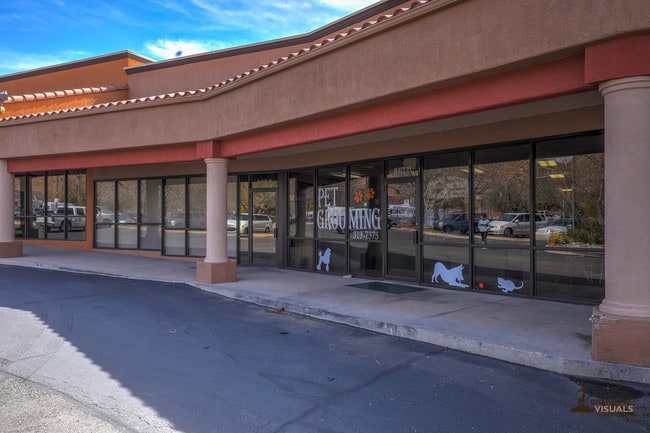
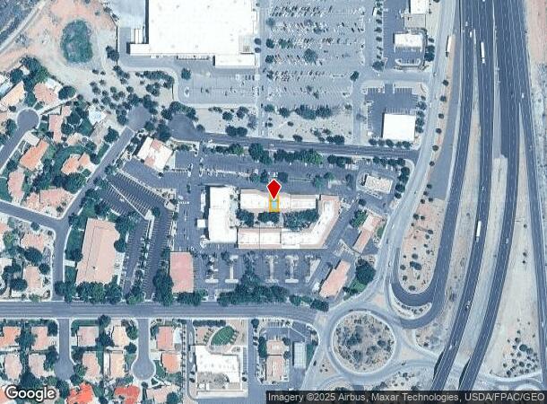
Property Record
144 W Brigham Rd, Saint George, UT 84790

NEARBY LISTINGS FOR SALE OR LEASE
Property Detail
144 W Brigham Rd
St. George, UT
Bloomington Courtyard Commercial Ctr 3
0605363
SUBDIVISION: BLOOMINGTON COURTYARD COMMERCIAL CENTER 3 (SG) LOT: 19
Commercialnec
Washington
X
Utah
49053C1037G
19
2024
0.03 AC
2025
Cedar City & St George
271600
Other Market Areas
1,250 SF
DEMOGRAPHICS near 144 W Brigham Rd
1 Mile
3 Mile
5 Mile
2024 Total Population
3,086
40,642
101,742
2029 Population
3,855
50,500
126,716
Pop Growth 2024-2029
+ 24.92%
+ 24.26%
+ 24.55%
Average Age
46
42
40
2024 Total Households
1,152
14,491
34,957
HH Growth 2024-2029
+ 25.52%
+ 24.78%
+ 25.19%
Median Household Inc
$79,537
$63,303
$62,989
Avg Household Size
2.70
2.70
2.80
2024 Avg HH Vehicles
2.00
2.00
2.00
Median Home Value
$437,000
$426,843
$430,385
Median Year Built
2001
1998
2000
Nearby Places
Map Layers
Map Styles
 Street
 Aerial
- Restaurants
- Banks
- Shops
- Fitness
- Groceries
PUBLIC TRANSPORTATION
AIRPORT
St George Regional
DRIVE
WALK
Distance
St George Regional
11 min
4.7 mi
Freight Ports
Port of Long Beach
DRIVE
WALK
Distance
Port of Long Beach
437 min
398.7 mi
SALE & LEASE HISTORY
LISTING DATE
SALE/LEASE

Sep 25, 2016
For Lease
Mar 21, 2019
For Sale
Mar 21, 2019
For Sale
Mar 10, 2020
For Lease
Aug 24, 2018
For Lease
Aug 05, 2017
For Sale
Apr 01, 2022
For Lease
Nearby Properties
Address
Land Use
TOTAL SIZE
Lot Size
Zoning
Address
Land Use
TOTAL SIZE
Lot Size
Zoning
823,767 SF
88.46 AC
Address
Land Use
TOTAL SIZE
Lot Size
Zoning
163,605 SF
13.51 AC
C3
Address
Land Use
TOTAL SIZE
Lot Size
Zoning
322,075 SF
26.62 AC
Address
Land Use
TOTAL SIZE
Lot Size
Zoning
175,817 SF
30.20 AC
Address
Land Use
TOTAL SIZE
Lot Size
Zoning
1,063.96 AC
R110
Address
Land Use
TOTAL SIZE
Lot Size
Zoning
259,012 SF
22 AC
M-1
Address
Land Use
TOTAL SIZE
Lot Size
Zoning
173,917 SF
50 AC
M-1
Address
Land Use
TOTAL SIZE
Lot Size
Zoning
206,801 SF
12.60 AC
PD
Address
Land Use
TOTAL SIZE
Lot Size
Zoning
9,037 SF
188.69 AC
C2
Address
Land Use
TOTAL SIZE
Lot Size
Zoning
196,334 SF
22.87 AC
PDCOM
Address
Land Use
TOTAL SIZE
Lot Size
Zoning
152,090 SF
25 AC
M-1
Address
Land Use
TOTAL SIZE
Lot Size
Zoning
87,750 SF
15.92 AC
Address
Land Use
TOTAL SIZE
Lot Size
Zoning
123,028 SF
12.87 AC
Address
Land Use
TOTAL SIZE
Lot Size
Zoning
97,202 SF
2.92 AC
C3
Address
Land Use
TOTAL SIZE
Lot Size
Zoning
94,810 SF
3.15 AC
C-3
Address
Land Use
TOTAL SIZE
Lot Size
Zoning
91,798 SF
5 AC
M-1
Address
Land Use
TOTAL SIZE
Lot Size
Zoning
59,500 SF
4.93 AC
R110
Address
Land Use
TOTAL SIZE
Lot Size
Zoning
15,476 SF
7.71 AC
Address
Land Use
TOTAL SIZE
Lot Size
Zoning
57,312 SF
3.14 AC
PDCOM
Address
Land Use
TOTAL SIZE
Lot Size
Zoning
169,923 SF
9.41 AC
Address
Land Use
TOTAL SIZE
Lot Size
Zoning
209,687 SF
7.54 AC
M-1
Address
Land Use
TOTAL SIZE
Lot Size
Zoning
67,139 SF
1.25 AC
Address
Land Use
TOTAL SIZE
Lot Size
Zoning
158,638 SF
4.67 AC
C-3
Address
Land Use
TOTAL SIZE
Lot Size
Zoning
82,440 SF
2.88 AC
Address
Land Use
TOTAL SIZE
Lot Size
Zoning
16,800 SF
250 AC
OS
Address
Land Use
TOTAL SIZE
Lot Size
Zoning
54,787 SF
4.30 AC
R110
Address
Land Use
TOTAL SIZE
Lot Size
Zoning
122,761 SF
10.22 AC
M-1
Address
Land Use
TOTAL SIZE
Lot Size
Zoning
76,560 SF
2.32 AC
Address
Land Use
TOTAL SIZE
Lot Size
Zoning
33,930 SF
11.65 AC
The World's #1 Commercial Real Estate Marketplace
Connect with us
© 2025 CoStar Group
The information above has been obtained from sources believed reliable. While we do not doubt its accuracy we have not verified it and make no guarantee, warranty or representation about it. It is your responsibility to independently confirm its accuracy and completeness. Any projections, opinions, assumptions, or estimates used are for example only and do not represent the current or future performance of the property. The value of this transaction to you depends on tax and other factors which should be evaluated by your tax, financial, and legal advisors. You and your advisors should conduct a careful, independent investigation of the property to determine to your satisfaction the suitability of the property for your needs.