Property Record
1440 Battelle Blvd, Richland, WA 99354
NEARBY LISTINGS FOR SALE OR LEASE
Property Detail
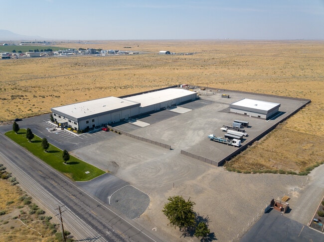
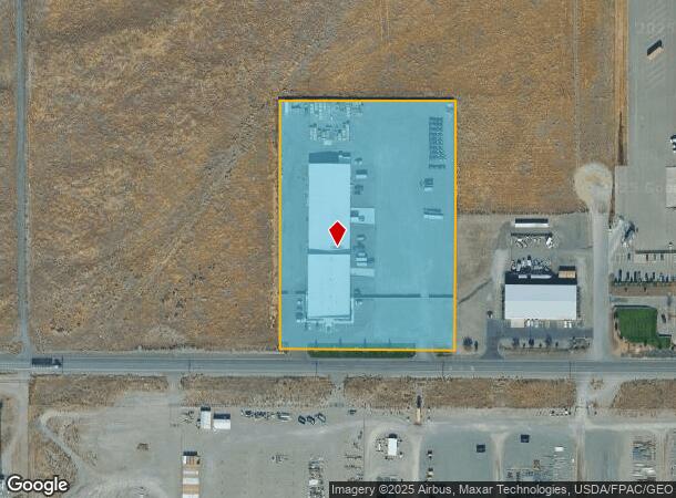
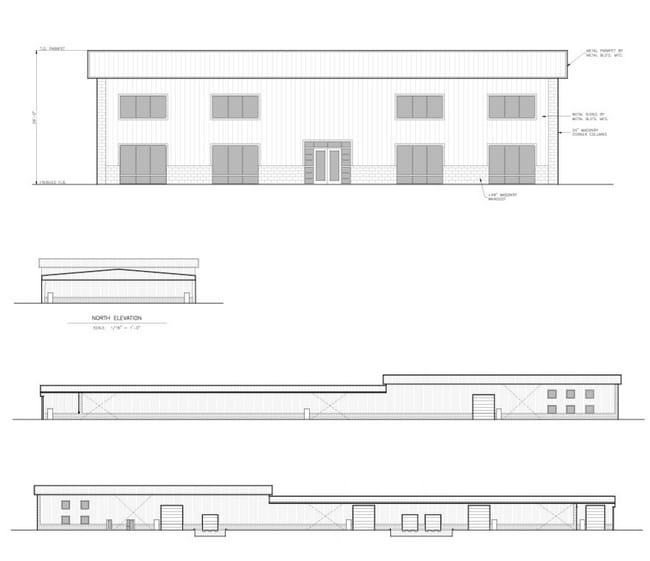
1440 Battelle Blvd
Kennewick-Richland, WA
THAT PORTION OF THE SOUTHEAST QUARTER OF SECTION 15, TOWNSHIP 10 NORTH, RANGE 28 EAST W.M., BENTON COUNTY, WASHINGTON, DESCRIBED AS FOLLOWS; COMMENCING AT THE SOUTHWEST CORNER OF SAID SOUTHEAST QUARTER THENCE NORTH 01-18G31G WEST ALONG THE WESTERLY L
115084000001005
Benton
Commercialnec
Washington
2024
6 AC
2024
Yakima/Kennewick
010201
Other Market Areas
41,632 SF
DEMOGRAPHICS near 1440 Battelle Blvd
1 Mile
3 Mile
5 Mile
2024 Total Population
219
12,858
37,599
2029 Population
230
13,840
40,469
Pop Growth 2024-2029
+ 5.02%
+ 7.64%
+ 7.63%
Average Age
38
42
39
2024 Total Households
144
5,353
14,747
HH Growth 2024-2029
+ 5.56%
+ 7.58%
+ 7.59%
Median Household Inc
$76,562
$106,427
$84,107
Avg Household Size
1.50
2.40
2.50
2024 Avg HH Vehicles
2.00
2.00
2.00
Median Home Value
$299,999
$363,570
$340,726
Median Year Built
2010
1984
1973
Nearby Places
Map Layers
Map Styles
 Street
 Aerial
- Restaurants
- Banks
- Shops
- Fitness
- Groceries
PUBLIC TRANSPORTATION
AIRPORT
Tri-Cities
DRIVE
WALK
Distance
Tri-Cities
25 min
16.8 mi
Freight Ports
Port of Tacoma
DRIVE
WALK
Distance
Port of Tacoma
261 min
213.6 mi
Nearby Properties
Address
Land Use
TOTAL SIZE
Lot Size
Zoning
Address
Land Use
TOTAL SIZE
Lot Size
Zoning
650,794 SF
55.19 AC
Address
Land Use
TOTAL SIZE
Lot Size
Zoning
351,518 SF
16.01 AC
Address
Land Use
TOTAL SIZE
Lot Size
Zoning
14,514 SF
160 AC
Address
Land Use
TOTAL SIZE
Lot Size
Zoning
5,948 SF
25 AC
Address
Land Use
TOTAL SIZE
Lot Size
Zoning
305,328 SF
83.37 AC
Address
Land Use
TOTAL SIZE
Lot Size
Zoning
12,866 SF
44.02 AC
Address
Land Use
TOTAL SIZE
Lot Size
Zoning
245,782 SF
10 AC
RICHLAND -
Address
Land Use
TOTAL SIZE
Lot Size
Zoning
148,367 SF
1 AC
Address
Land Use
TOTAL SIZE
Lot Size
Zoning
306,563 SF
14.60 AC
Address
Land Use
TOTAL SIZE
Lot Size
Zoning
277,559 SF
30 AC
Address
Land Use
TOTAL SIZE
Lot Size
Zoning
201,040 SF
4.24 AC
Address
Land Use
TOTAL SIZE
Lot Size
Zoning
719,130 SF
75 AC
RICHLAND -
Address
Land Use
TOTAL SIZE
Lot Size
Zoning
47,160 SF
14.28 AC
Address
Land Use
TOTAL SIZE
Lot Size
Zoning
280,136 SF
Address
Land Use
TOTAL SIZE
Lot Size
Zoning
106,500 SF
3.83 AC
Address
Land Use
TOTAL SIZE
Lot Size
Zoning
90,520 SF
4.32 AC
RICHLAND -
Address
Land Use
TOTAL SIZE
Lot Size
Zoning
94,714 SF
5.22 AC
Address
Land Use
TOTAL SIZE
Lot Size
Zoning
100,872 SF
1 AC
Address
Land Use
TOTAL SIZE
Lot Size
Zoning
100,872 SF
1 AC
Address
Land Use
TOTAL SIZE
Lot Size
Zoning
233,709 SF
39.16 AC
Address
Land Use
TOTAL SIZE
Lot Size
Zoning
69,697 SF
16.83 AC
Address
Land Use
TOTAL SIZE
Lot Size
Zoning
280.55 AC
Address
Land Use
TOTAL SIZE
Lot Size
Zoning
150,522 SF
Address
Land Use
TOTAL SIZE
Lot Size
Zoning
93,484 SF
61.65 AC
Address
Land Use
TOTAL SIZE
Lot Size
Zoning
99,320 SF
5.37 AC
Address
Land Use
TOTAL SIZE
Lot Size
Zoning
208,285 SF
5.24 AC
Address
Land Use
TOTAL SIZE
Lot Size
Zoning
80,597 SF
6.37 AC
Address
Land Use
TOTAL SIZE
Lot Size
Zoning
136,013 SF
7.09 AC
Address
Land Use
TOTAL SIZE
Lot Size
Zoning
26,182 SF
3.62 AC
Address
Land Use
TOTAL SIZE
Lot Size
Zoning
577.25 AC
The World's #1 Commercial Real Estate Marketplace
Connect with us
© 2026 CoStar Group
The information above has been obtained from sources believed reliable. While we do not doubt its accuracy we have not verified it and make no guarantee, warranty or representation about it. It is your responsibility to independently confirm its accuracy and completeness. Any projections, opinions, assumptions, or estimates used are for example only and do not represent the current or future performance of the property. The value of this transaction to you depends on tax and other factors which should be evaluated by your tax, financial, and legal advisors. You and your advisors should conduct a careful, independent investigation of the property to determine to your satisfaction the suitability of the property for your needs.