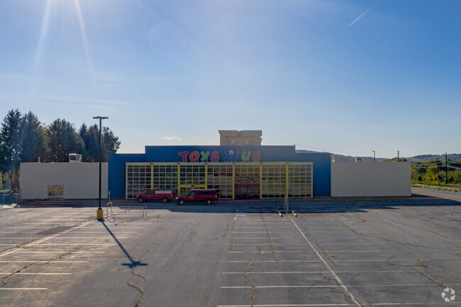
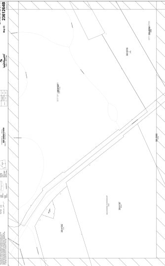
Property Record
1440 Harrisburg Pike, Lancaster, PA 17601
NEARBY LISTINGS FOR SALE OR LEASE
Property Detail
1440 Harrisburg Pike
Lancaster, PA
Lancaster
390-33960-1-0002
Pennsylvania
Commercialcondominium
0.93 AC
2024
Lancaster County
2025
Philadelphia
011806
DEMOGRAPHICS near 1440 Harrisburg Pike
1 Mile
3 Mile
5 Mile
2024 Total Population
3,770
103,263
194,819
2029 Population
3,780
104,099
196,572
Pop Growth 2024-2029
+ 0.27%
+ 0.81%
+ 0.90%
Average Age
44
39
40
2024 Total Households
1,670
40,548
73,952
HH Growth 2024-2029
(0.30%)
+ 0.74%
+ 0.86%
Median Household Inc
$87,222
$70,920
$74,948
Avg Household Size
2.10
2.40
2.40
2024 Avg HH Vehicles
2.00
2.00
2.00
Median Home Value
$274,247
$231,531
$244,575
Median Year Built
1987
1957
1971
Nearby Places
- Restaurants
- Banks
- Shops
- Fitness
- Groceries
PUBLIC TRANSPORTATION
COMMUTER RAIL
Lancaster (Keystone Service - Amtrak, Pennsylvanian - Amtrak)
DRIVE
WALK
Distance
Lancaster (Keystone Service - Amtrak, Pennsylvanian - Amtrak)
5 min
2.1 mi
AIRPORT
Harrisburg International
DRIVE
WALK
Distance
Harrisburg International
40 min
29.9 mi
Freight Ports
Port of Wilmington, RI
DRIVE
WALK
Distance
Port of Wilmington, RI
96 min
55.9 mi
Nearby Properties
Address
Land Use
TOTAL SIZE
Lot Size
Zoning
Address
Land Use
TOTAL SIZE
Lot Size
Zoning
822,920 SF
97.54 AC
HCD
Address
Land Use
TOTAL SIZE
Lot Size
Zoning
1,603,151 SF
104.89 AC
C3
Address
Land Use
TOTAL SIZE
Lot Size
Zoning
526,898 SF
26.10 AC
AH
Address
Land Use
TOTAL SIZE
Lot Size
Zoning
1,003,686 SF
127.66 AC
HR
Address
Land Use
TOTAL SIZE
Lot Size
Zoning
206,666 SF
1 AC
CB1
Address
Land Use
TOTAL SIZE
Lot Size
Zoning
712,737 SF
52.50 AC
R2
Address
Land Use
TOTAL SIZE
Lot Size
Zoning
269,860 SF
0.90 AC
CB1
Address
Land Use
TOTAL SIZE
Lot Size
Zoning
315,373 SF
4.73 AC
DF
Address
Land Use
TOTAL SIZE
Lot Size
Zoning
941,905 SF
141.50 AC
I
Address
Land Use
TOTAL SIZE
Lot Size
Zoning
905,200 SF
68.60 AC
Address
Land Use
TOTAL SIZE
Lot Size
Zoning
275,959 SF
68.50 AC
IN
Address
Land Use
TOTAL SIZE
Lot Size
Zoning
642,651 SF
2.16 AC
CA
Address
Land Use
TOTAL SIZE
Lot Size
Zoning
308,727 SF
11.37 AC
Address
Land Use
TOTAL SIZE
Lot Size
Zoning
178,234 SF
0.78 AC
CB
Address
Land Use
TOTAL SIZE
Lot Size
Zoning
193,864 SF
9 AC
Address
Land Use
TOTAL SIZE
Lot Size
Zoning
203,415 SF
10.74 AC
Address
Land Use
TOTAL SIZE
Lot Size
Zoning
99,894 SF
21.88 AC
Address
Land Use
TOTAL SIZE
Lot Size
Zoning
135,998 SF
28.64 AC
HR
Address
Land Use
TOTAL SIZE
Lot Size
Zoning
254,079 SF
21.54 AC
Address
Land Use
TOTAL SIZE
Lot Size
Zoning
234,681 SF
7.50 AC
MU
Address
Land Use
TOTAL SIZE
Lot Size
Zoning
223,327 SF
21.80 AC
B-4
Address
Land Use
TOTAL SIZE
Lot Size
Zoning
203,942 SF
21.22 AC
B-4
Address
Land Use
TOTAL SIZE
Lot Size
Zoning
691,290 SF
3 AC
Address
Land Use
TOTAL SIZE
Lot Size
Zoning
372,708 SF
50.40 AC
HR
Address
Land Use
TOTAL SIZE
Lot Size
Zoning
246,742 SF
12.49 AC
B-4
Address
Land Use
TOTAL SIZE
Lot Size
Zoning
128,939 SF
27.39 AC
Address
Land Use
TOTAL SIZE
Lot Size
Zoning
101,558 SF
28.14 AC
AH
Address
Land Use
TOTAL SIZE
Lot Size
Zoning
199,107 SF
26.20 AC
CC
Address
Land Use
TOTAL SIZE
Lot Size
Zoning
131,294 SF
11.14 AC
B-4
Address
Land Use
TOTAL SIZE
Lot Size
Zoning
385,561 SF
27.20 AC
The World's #1 Commercial Real Estate Marketplace
Connect with us
© 2025 CoStar Group
The information above has been obtained from sources believed reliable. While we do not doubt its accuracy we have not verified it and make no guarantee, warranty or representation about it. It is your responsibility to independently confirm its accuracy and completeness. Any projections, opinions, assumptions, or estimates used are for example only and do not represent the current or future performance of the property. The value of this transaction to you depends on tax and other factors which should be evaluated by your tax, financial, and legal advisors. You and your advisors should conduct a careful, independent investigation of the property to determine to your satisfaction the suitability of the property for your needs.