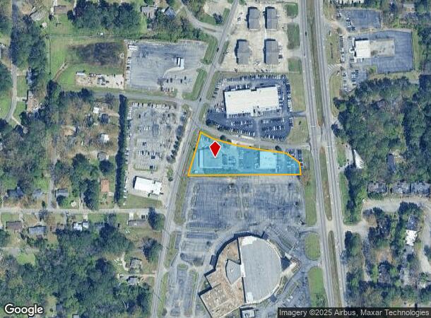
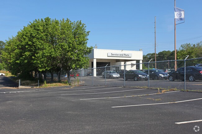
Property Record
1440 Huffman Rd, Birmingham, AL 35215

NEARBY LISTINGS FOR SALE OR LEASE
Property Detail
1440 Huffman Rd
12-00-19-3-008-001.000
BEG AT INT OF S R/W OF LAKE DR & E R/W OF CENTER POINT RD TH ELY ALG LAKE DR 400 FT S TH SELY 80 FT S TH SELY ALG PARKWAY EAST 60 FT S TH WLY 510 FT S THNELY ALG CENTER POINT RD 230 FT D 206 FT S TO P O B SEC 19 TP 16 R 1W
Vehiclerentalsvehiclesales
Jefferson
X
Alabama
01073C0406J
1.48 AC
2023
Center Point
2024
Birmingham
011803
Birmingham-Hoover, AL
8,951 SF
DEMOGRAPHICS near 1440 Huffman Rd
1 Mile
3 Mile
5 Mile
2024 Total Population
10,583
56,198
96,036
2029 Population
10,571
55,091
94,249
Pop Growth 2024-2029
(0.11%)
(1.97%)
(1.86%)
Average Age
35
37
38
2024 Total Households
3,983
21,244
36,572
HH Growth 2024-2029
(0.10%)
(2.01%)
(1.94%)
Median Household Inc
$36,969
$47,853
$49,823
Avg Household Size
2.60
2.50
2.50
2024 Avg HH Vehicles
2.00
2.00
2.00
Median Home Value
$115,249
$142,320
$153,211
Median Year Built
1972
1974
1975
Nearby Places
Map Layers
Map Styles
 Street
 Aerial
- Restaurants
- Banks
- Shops
- Fitness
- Groceries
PUBLIC TRANSPORTATION
AIRPORT
Birmingham-Shuttlesworth International
DRIVE
WALK
Distance
Birmingham-Shuttlesworth International
14 min
8.2 mi
Freight Ports
Port of Mobile
DRIVE
WALK
Distance
Port of Mobile
295 min
269.0 mi
Nearby Properties
Address
Land Use
TOTAL SIZE
Lot Size
Zoning
Address
Land Use
TOTAL SIZE
Lot Size
Zoning
152,664 SF
12.44 AC
CO&I
Address
Land Use
TOTAL SIZE
Lot Size
Zoning
326,294 SF
25.99 AC
R4&U
Address
Land Use
TOTAL SIZE
Lot Size
Zoning
128,233 SF
CO&I
Address
Land Use
TOTAL SIZE
Lot Size
Zoning
150,160 SF
12 AC
INST
Address
Land Use
TOTAL SIZE
Lot Size
Zoning
1 SF
7.08 AC
CB2
Address
Land Use
TOTAL SIZE
Lot Size
Zoning
94,262 SF
17.30 AC
C-2
Address
Land Use
TOTAL SIZE
Lot Size
Zoning
58,509 SF
CO&I
Address
Land Use
TOTAL SIZE
Lot Size
Zoning
207,383 SF
17 AC
CR5
Address
Land Use
TOTAL SIZE
Lot Size
Zoning
39,890 SF
7.10 AC
R8
Address
Land Use
TOTAL SIZE
Lot Size
Zoning
57,296 SF
CO&I
Address
Land Use
TOTAL SIZE
Lot Size
Zoning
623,200 SF
50 AC
CM2
Address
Land Use
TOTAL SIZE
Lot Size
Zoning
218,922 SF
21 AC
CR5
Address
Land Use
TOTAL SIZE
Lot Size
Zoning
112,806 SF
2.04 AC
R2
Address
Land Use
TOTAL SIZE
Lot Size
Zoning
166,144 SF
12.95 AC
CB2
Address
Land Use
TOTAL SIZE
Lot Size
Zoning
412,320 SF
16.50 AC
I2
Address
Land Use
TOTAL SIZE
Lot Size
Zoning
178,988 SF
8.29 AC
CR5
Address
Land Use
TOTAL SIZE
Lot Size
Zoning
205,872 SF
12.53 AC
CB2
Address
Land Use
TOTAL SIZE
Lot Size
Zoning
192,596 SF
13.79 AC
CR5
Address
Land Use
TOTAL SIZE
Lot Size
Zoning
147,200 SF
7.93 AC
CR5
Address
Land Use
TOTAL SIZE
Lot Size
Zoning
531,808 SF
23.96 AC
I4&A
Address
Land Use
TOTAL SIZE
Lot Size
Zoning
148,245 SF
9.30 AC
CR5
Address
Land Use
TOTAL SIZE
Lot Size
Zoning
502,302 SF
24.61 AC
I4&A
Address
Land Use
TOTAL SIZE
Lot Size
Zoning
115,490 SF
3.88 AC
R2
Address
Land Use
TOTAL SIZE
Lot Size
Zoning
149,773 SF
7.30 AC
CR5
Address
Land Use
TOTAL SIZE
Lot Size
Zoning
95,172 SF
6.40 AC
R2
Address
Land Use
TOTAL SIZE
Lot Size
Zoning
71,028 SF
9.90 AC
O-I
Address
Land Use
TOTAL SIZE
Lot Size
Zoning
125,252 SF
8.07 AC
R4
Address
Land Use
TOTAL SIZE
Lot Size
Zoning
116,759 SF
6.10 AC
CR5
Address
Land Use
TOTAL SIZE
Lot Size
Zoning
97,652 SF
6.20 AC
C2
Address
Land Use
TOTAL SIZE
Lot Size
Zoning
122,397 SF
13.13 AC
C1
The World's #1 Commercial Real Estate Marketplace
Connect with us
© 2025 CoStar Group
The information above has been obtained from sources believed reliable. While we do not doubt its accuracy we have not verified it and make no guarantee, warranty or representation about it. It is your responsibility to independently confirm its accuracy and completeness. Any projections, opinions, assumptions, or estimates used are for example only and do not represent the current or future performance of the property. The value of this transaction to you depends on tax and other factors which should be evaluated by your tax, financial, and legal advisors. You and your advisors should conduct a careful, independent investigation of the property to determine to your satisfaction the suitability of the property for your needs.