Property Record
14405 Highway 65 Ne, Andover, MN 55304

NEARBY LISTINGS FOR SALE OR LEASE
-
-
View all Andover listings for sale on LoopNet.com
Property Detail
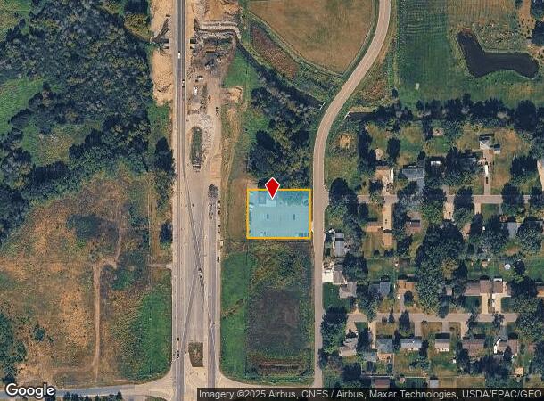
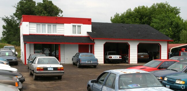
14405 Highway 65 Ne
29-32-23-42-0006
THAT PRT OF NW1/4 OF SE1/4 OF SEC 29 TWP 32 RGE 23 DESC AS FOL: BEG AT INTER OF NLY R/W LINE OF 144TH AVE NE WITH WLY R/W LIN
Commercialnec
Anoka
AE
Minnesota
27003C0326E
0.69 AC
2025
Coon Rapids
2025
Minneapolis/St Paul
050215
Minneapolis-St. Paul-Bloomington, MN-WI
2,968 SF
DEMOGRAPHICS near 14405 Highway 65 Ne
1 Mile
3 Mile
5 Mile
2024 Total Population
1,632
30,925
109,143
2029 Population
1,682
32,173
113,726
Pop Growth 2024-2029
+ 3.06%
+ 4.04%
+ 4.20%
Average Age
43
39
39
2024 Total Households
570
10,581
37,779
HH Growth 2024-2029
+ 3.16%
+ 3.92%
+ 4.16%
Median Household Inc
$120,967
$114,002
$106,679
Avg Household Size
2.80
2.90
2.80
2024 Avg HH Vehicles
3.00
2.00
2.00
Median Home Value
$432,927
$355,698
$336,310
Median Year Built
1995
1994
1994
Nearby Places
Map Layers
Map Styles
 Street
 Aerial
- Restaurants
- Banks
- Shops
- Fitness
- Groceries
PUBLIC TRANSPORTATION
COMMUTER RAIL
Coon Rapids-Riverdale Station (Northstar Corridor - Northstar Commuter Rail)
DRIVE
WALK
Distance
Coon Rapids-Riverdale Station (Northstar Corridor - Northstar Commuter Rail)
16 min
8.8 mi
AIRPORT
Minneapolis-St Paul International/Wold-Chamberlain
DRIVE
WALK
Distance
Minneapolis-St Paul International/Wold-Chamberlain
45 min
30.6 mi
Freight Ports
Port Milwaukee
DRIVE
WALK
Distance
Port Milwaukee
391 min
352.8 mi
Nearby Properties
Address
Land Use
TOTAL SIZE
Lot Size
Zoning
Address
Land Use
TOTAL SIZE
Lot Size
Zoning
1,075 SF
41.99 AC
Address
Land Use
TOTAL SIZE
Lot Size
Zoning
179,853 SF
37.73 AC
Address
Land Use
TOTAL SIZE
Lot Size
Zoning
192 SF
11.30 AC
Address
Land Use
TOTAL SIZE
Lot Size
Zoning
76,383 SF
7.60 AC
Address
Land Use
TOTAL SIZE
Lot Size
Zoning
98,642 SF
20.01 AC
Address
Land Use
TOTAL SIZE
Lot Size
Zoning
104,477 SF
18 AC
Address
Land Use
TOTAL SIZE
Lot Size
Zoning
135,994 SF
3.20 AC
Address
Land Use
TOTAL SIZE
Lot Size
Zoning
162,450 SF
9.97 AC
Address
Land Use
TOTAL SIZE
Lot Size
Zoning
8,410 SF
12.69 AC
Address
Land Use
TOTAL SIZE
Lot Size
Zoning
76,374 SF
4.91 AC
Address
Land Use
TOTAL SIZE
Lot Size
Zoning
10,912 SF
1.97 AC
Address
Land Use
TOTAL SIZE
Lot Size
Zoning
8,680 SF
8.12 AC
Address
Land Use
TOTAL SIZE
Lot Size
Zoning
Address
Land Use
TOTAL SIZE
Lot Size
Zoning
70,304 SF
Address
Land Use
TOTAL SIZE
Lot Size
Zoning
Address
Land Use
TOTAL SIZE
Lot Size
Zoning
6,080 SF
20 AC
Address
Land Use
TOTAL SIZE
Lot Size
Zoning
26,719 SF
36.48 AC
Address
Land Use
TOTAL SIZE
Lot Size
Zoning
3,744 SF
0.92 AC
Address
Land Use
TOTAL SIZE
Lot Size
Zoning
77,272 SF
3.09 AC
Address
Land Use
TOTAL SIZE
Lot Size
Zoning
50,710 SF
3.43 AC
Address
Land Use
TOTAL SIZE
Lot Size
Zoning
74,720 SF
5.24 AC
Address
Land Use
TOTAL SIZE
Lot Size
Zoning
54,272 SF
4.97 AC
Address
Land Use
TOTAL SIZE
Lot Size
Zoning
53,180 SF
30.46 AC
Address
Land Use
TOTAL SIZE
Lot Size
Zoning
58,977 SF
5.65 AC
Address
Land Use
TOTAL SIZE
Lot Size
Zoning
8,204 SF
12.39 AC
Address
Land Use
TOTAL SIZE
Lot Size
Zoning
55,932 SF
5.39 AC
Address
Land Use
TOTAL SIZE
Lot Size
Zoning
1,100 SF
41.96 AC
Address
Land Use
TOTAL SIZE
Lot Size
Zoning
24,000 SF
Address
Land Use
TOTAL SIZE
Lot Size
Zoning
1,182 SF
20.50 AC
The World's #1 Commercial Real Estate Marketplace
Connect with us
© 2025 CoStar Group
The information above has been obtained from sources believed reliable. While we do not doubt its accuracy we have not verified it and make no guarantee, warranty or representation about it. It is your responsibility to independently confirm its accuracy and completeness. Any projections, opinions, assumptions, or estimates used are for example only and do not represent the current or future performance of the property. The value of this transaction to you depends on tax and other factors which should be evaluated by your tax, financial, and legal advisors. You and your advisors should conduct a careful, independent investigation of the property to determine to your satisfaction the suitability of the property for your needs.