Property Record
1441 Mall Dr, Council Bluffs, IA 51503
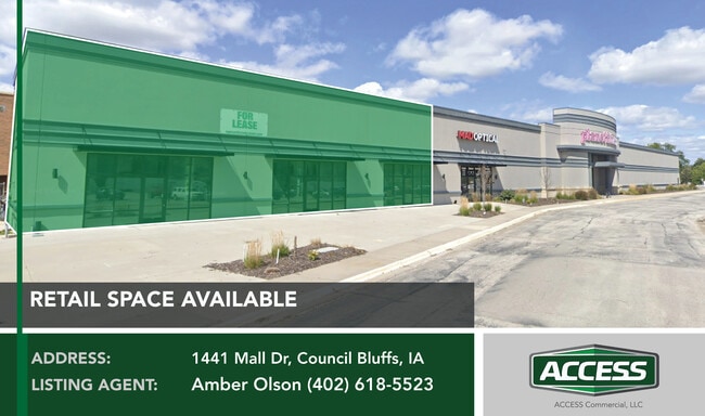

Current Lease Availabilities
NEARBY LISTINGS FOR SALE OR LEASE
Property Detail
1441 Mall Dr
Omaha/Council Bluffs
Mall Of The Bluffs Replat 1
Omaha-Council Bluffs, NE-IA
MALL OF THE BLUFFS REPLAT 1 LT 3
7443 05 502 006
Pottawattamie
Storebuilding
Iowa
2025
3
2025
14.86 AC
031200
Council Bluffs
DEMOGRAPHICS near 1441 Mall Dr
1 Mile
3 Mile
5 Mile
2024 Total Population
5,869
42,846
68,979
2029 Population
5,878
42,996
69,016
Pop Growth 2024-2029
+ 0.15%
+ 0.35%
+ 0.05%
Average Age
43
41
41
2024 Total Households
2,505
17,161
27,456
HH Growth 2024-2029
+ 0.08%
+ 0.38%
+ 0.06%
Median Household Inc
$101,646
$67,483
$66,770
Avg Household Size
2.30
2.30
2.40
2024 Avg HH Vehicles
2.00
2.00
2.00
Median Home Value
$253,185
$216,796
$199,457
Median Year Built
1976
1967
1966
Nearby Places
Map Layers
Map Styles
 Street
 Aerial
- Restaurants
- Banks
- Shops
- Fitness
- Groceries
PUBLIC TRANSPORTATION
COMMUTER RAIL
Omaha Amtrak Station (California Zephyr - Amtrak)
DRIVE
WALK
Distance
Omaha Amtrak Station (California Zephyr - Amtrak)
13 min
8.5 mi
Omaha Amtrak Station (California Zephyr - Amtrak)
DRIVE
WALK
Distance
Omaha Amtrak Station (California Zephyr - Amtrak)
14 min
8.7 mi
AIRPORT
Eppley Airfield
DRIVE
WALK
Distance
Eppley Airfield
22 min
11.9 mi
Freight Ports
Tulsa Port Of Catoosa
DRIVE
WALK
Distance
Tulsa Port Of Catoosa
457 min
414.3 mi
Nearby Properties
Address
Land Use
TOTAL SIZE
Lot Size
Zoning
Address
Land Use
TOTAL SIZE
Lot Size
Zoning
185.50 AC
A-2
Address
Land Use
TOTAL SIZE
Lot Size
Zoning
52.44 AC
I-2
Address
Land Use
TOTAL SIZE
Lot Size
Zoning
11.85 AC
R-3
Address
Land Use
TOTAL SIZE
Lot Size
Zoning
16.87 AC
P-C
Address
Land Use
TOTAL SIZE
Lot Size
Zoning
17.49 AC
R-3
Address
Land Use
TOTAL SIZE
Lot Size
Zoning
68.36 AC
R-1M
Address
Land Use
TOTAL SIZE
Lot Size
Zoning
2.91 AC
A-P
Address
Land Use
TOTAL SIZE
Lot Size
Zoning
17.40 AC
A-P
Address
Land Use
TOTAL SIZE
Lot Size
Zoning
37.25 AC
I-2
Address
Land Use
TOTAL SIZE
Lot Size
Zoning
4,216 SF
17.29 AC
R-4
Address
Land Use
TOTAL SIZE
Lot Size
Zoning
3,552 SF
18.50 AC
I-2
Address
Land Use
TOTAL SIZE
Lot Size
Zoning
22.91 AC
A-P
Address
Land Use
TOTAL SIZE
Lot Size
Zoning
30.64 AC
R-1
Address
Land Use
TOTAL SIZE
Lot Size
Zoning
8.34 AC
R-3
Address
Land Use
TOTAL SIZE
Lot Size
Zoning
1.99 AC
C-3
Address
Land Use
TOTAL SIZE
Lot Size
Zoning
21.72 AC
I-2
Address
Land Use
TOTAL SIZE
Lot Size
Zoning
21.91 AC
P-C
Address
Land Use
TOTAL SIZE
Lot Size
Zoning
582.98 AC
A-2
Address
Land Use
TOTAL SIZE
Lot Size
Zoning
18.68 AC
C-2
Address
Land Use
TOTAL SIZE
Lot Size
Zoning
18.41 AC
R-3
Address
Land Use
TOTAL SIZE
Lot Size
Zoning
9.06 AC
R-3
Address
Land Use
TOTAL SIZE
Lot Size
Zoning
4.48 AC
R-4
Address
Land Use
TOTAL SIZE
Lot Size
Zoning
34.64 AC
I-2
Address
Land Use
TOTAL SIZE
Lot Size
Zoning
7.72 AC
P-C
Address
Land Use
TOTAL SIZE
Lot Size
Zoning
7.17 AC
R-3
Address
Land Use
TOTAL SIZE
Lot Size
Zoning
8.42 AC
R-3
Address
Land Use
TOTAL SIZE
Lot Size
Zoning
28.70 AC
A-P
Address
Land Use
TOTAL SIZE
Lot Size
Zoning
4.87 AC
C-2
Address
Land Use
TOTAL SIZE
Lot Size
Zoning
9.97 AC
P-C
Address
Land Use
TOTAL SIZE
Lot Size
Zoning
864 SF
7.37 AC
C-2
The World's #1 Commercial Real Estate Marketplace
Connect with us
© 2026 CoStar Group
The information above has been obtained from sources believed reliable. While we do not doubt its accuracy we have not verified it and make no guarantee, warranty or representation about it. It is your responsibility to independently confirm its accuracy and completeness. Any projections, opinions, assumptions, or estimates used are for example only and do not represent the current or future performance of the property. The value of this transaction to you depends on tax and other factors which should be evaluated by your tax, financial, and legal advisors. You and your advisors should conduct a careful, independent investigation of the property to determine to your satisfaction the suitability of the property for your needs.