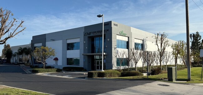
Property Record
1441 S Carlos Ave, Ontario, CA 91761


Current Lease Availabilities
NEARBY LISTINGS FOR SALE OR LEASE
Property Detail
1441 S Carlos Ave
0113-395-47
PARCEL MAP 15362 PARCEL 1 BOOK 196 PAGE 15
Lightindustrial
San Bernardino
X
California
06071C8636J
1 AC
2024
Airport Area
2025
Inland Empire (California)
001803
Riverside-San Bernardino-Ontario, CA
16,196 SF
DEMOGRAPHICS near 1441 S Carlos Ave
1 Mile
3 Mile
5 Mile
2024 Total Population
212
111,315
310,676
2029 Population
216
113,095
316,998
Pop Growth 2024-2029
+ 1.89%
+ 1.60%
+ 2.03%
Average Age
34
36
37
2024 Total Households
50
31,995
95,313
HH Growth 2024-2029
+ 2.00%
+ 1.65%
+ 2.11%
Median Household Inc
$90,624
$78,630
$82,391
Avg Household Size
3.60
3.40
3.10
2024 Avg HH Vehicles
2.00
2.00
2.00
Median Home Value
$596,154
$492,350
$549,619
Median Year Built
1963
1980
1981
Nearby Places
Map Layers
Map Styles
 Street
 Aerial
- Restaurants
- Banks
- Shops
- Fitness
- Groceries
PUBLIC TRANSPORTATION
COMMUTER RAIL
East Ontario (Riverside Line - Southern California Regional Rail Authority (Metrolink))
DRIVE
WALK
Distance
East Ontario (Riverside Line - Southern California Regional Rail Authority (Metrolink))
6 min
2.5 mi
DRIVE
WALK
Distance
7 min
3.9 mi
AIRPORT
Ontario International
DRIVE
WALK
Distance
Ontario International
9 min
4.2 mi
John Wayne/Orange County
DRIVE
WALK
Distance
John Wayne/Orange County
51 min
42.3 mi
Freight Ports
Port of Long Beach
DRIVE
WALK
Distance
Port of Long Beach
67 min
51.2 mi
Nearby Properties
Address
Land Use
TOTAL SIZE
Lot Size
Zoning
Address
Land Use
TOTAL SIZE
Lot Size
Zoning
1,281,803 SF
27.85 AC
Address
Land Use
TOTAL SIZE
Lot Size
Zoning
244,370 SF
59.72 AC
Address
Land Use
TOTAL SIZE
Lot Size
Zoning
539,128 SF
10.24 AC
Address
Land Use
TOTAL SIZE
Lot Size
Zoning
336,640 SF
20.87 AC
Address
Land Use
TOTAL SIZE
Lot Size
Zoning
336,640 SF
20.44 AC
R2
Address
Land Use
TOTAL SIZE
Lot Size
Zoning
545,161 SF
11.10 AC
Address
Land Use
TOTAL SIZE
Lot Size
Zoning
591,495 SF
18.29 AC
Address
Land Use
TOTAL SIZE
Lot Size
Zoning
1,052,840 SF
41.85 AC
Address
Land Use
TOTAL SIZE
Lot Size
Zoning
531,988 SF
9.83 AC
Address
Land Use
TOTAL SIZE
Lot Size
Zoning
440,209 SF
10.34 AC
Address
Land Use
TOTAL SIZE
Lot Size
Zoning
830,300 SF
39.99 AC
Address
Land Use
TOTAL SIZE
Lot Size
Zoning
317,070 SF
14.26 AC
Address
Land Use
TOTAL SIZE
Lot Size
Zoning
387,965 SF
10.92 AC
Address
Land Use
TOTAL SIZE
Lot Size
Zoning
817,493 SF
93.45 AC
Address
Land Use
TOTAL SIZE
Lot Size
Zoning
797,408 SF
66.66 AC
Address
Land Use
TOTAL SIZE
Lot Size
Zoning
709,814 SF
29.40 AC
Address
Land Use
TOTAL SIZE
Lot Size
Zoning
923,083 SF
48.34 AC
Address
Land Use
TOTAL SIZE
Lot Size
Zoning
656,040 SF
28.47 AC
Address
Land Use
TOTAL SIZE
Lot Size
Zoning
245,931 SF
10.84 AC
Address
Land Use
TOTAL SIZE
Lot Size
Zoning
123,833 SF
11.23 AC
Address
Land Use
TOTAL SIZE
Lot Size
Zoning
174,430 SF
7.47 AC
Address
Land Use
TOTAL SIZE
Lot Size
Zoning
573,220 SF
32.33 AC
Address
Land Use
TOTAL SIZE
Lot Size
Zoning
780,648 SF
13.59 AC
Address
Land Use
TOTAL SIZE
Lot Size
Zoning
217,758 SF
12.02 AC
Address
Land Use
TOTAL SIZE
Lot Size
Zoning
760,158 SF
32.77 AC
Address
Land Use
TOTAL SIZE
Lot Size
Zoning
199,158 SF
8.55 AC
Address
Land Use
TOTAL SIZE
Lot Size
Zoning
273,249 SF
11.07 AC
Address
Land Use
TOTAL SIZE
Lot Size
Zoning
205,422 SF
14.53 AC
R3
Address
Land Use
TOTAL SIZE
Lot Size
Zoning
303,915 SF
11.13 AC
Address
Land Use
TOTAL SIZE
Lot Size
Zoning
553,882 SF
24.59 AC
The World's #1 Commercial Real Estate Marketplace
Connect with us
© 2026 CoStar Group
The information above has been obtained from sources believed reliable. While we do not doubt its accuracy we have not verified it and make no guarantee, warranty or representation about it. It is your responsibility to independently confirm its accuracy and completeness. Any projections, opinions, assumptions, or estimates used are for example only and do not represent the current or future performance of the property. The value of this transaction to you depends on tax and other factors which should be evaluated by your tax, financial, and legal advisors. You and your advisors should conduct a careful, independent investigation of the property to determine to your satisfaction the suitability of the property for your needs.