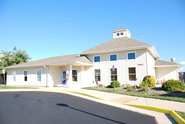
Property Record
14421 Newbern Loop, Gainesville, VA 20155


Save to a Folder
{{folder.Name}}
{{folder.ListingIds.length}} Properties
{{folder.ListingIds.length}} Property
Create a New Folder
Property Detail
14421 Newbern Loop
7397-49-9361
CROSSROADS VILLAGE SEC 5 PCL B
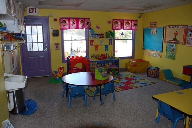
Daycare
Prince William
R16
Virginia
B and X Area of moderate flood hazard, usually the area between the limits of the 100-year and 500-year floods.
9361
2024
0.95 AC
2025
Route 29/I-66 Corridor
901506
Washington, DC
5,027 SF
Washington-Arlington-Alexandria, DC-VA-MD-WV
NEARBY LISTINGS FOR SALE OR LEASE
DEMOGRAPHICS near 14421 Newbern Loop
1 mile
3 mile
5 mile
2025 Total Population
13,432
50,687
93,262
2030 Population
13,841
52,209
96,015
Pop Growth 2025-2030
+ 3.04%
+ 3.00%
+ 2.95%
Average Age
40
41
39
2025 Total Households
4,561
16,734
29,808
HH Growth 2025-2030
+ 2.83%
+ 2.93%
+ 2.91%
Median Household Inc
$158,074
$170,515
$170,692
Avg Household Size
2.90
3.00
3.10
2025 Avg HH Vehicles
2.00
2.00
2.00
Median Home Value
$573,985
$704,251
$706,853
Median Year Built
2004
2004
2004
Nearby Places
Map Layers
Map Styles
 Street
 Aerial
Layers
 Traffic
 Biking
Places
Listings with unknown addresses are not visible on the map
- Restaurants
- Banks
- Shops
- Fitness
- Groceries
PUBLIC TRANSPORTATION
AIRPORT
Washington Dulles International
Drive
Walk
Distance
Washington Dulles International
37 min
23.0 mi
Ronald Reagan Washington Ntl
Drive
Walk
Distance
Ronald Reagan Washington Ntl
50 min
37.6 mi
Nearby Properties
Address
Land Use
TOTAL SIZE
Lot Size
Zoning
Address
Land Use
TOTAL SIZE
Lot Size
Zoning
482,223 SF
28.10 AC
PBD
Address
Land Use
TOTAL SIZE
Lot Size
Zoning
453,174 SF
38.50 AC
PBD
Address
Land Use
TOTAL SIZE
Lot Size
Zoning
560,942 SF
90.90 AC
B1
Address
Land Use
TOTAL SIZE
Lot Size
Zoning
181.29 AC
M1
Address
Land Use
TOTAL SIZE
Lot Size
Zoning
117.22 AC
M1
Address
Land Use
TOTAL SIZE
Lot Size
Zoning
252,966 SF
10.54 AC
PMD
Address
Land Use
TOTAL SIZE
Lot Size
Zoning
258,716 SF
58.54 AC
M1
Address
Land Use
TOTAL SIZE
Lot Size
Zoning
350,906 SF
83.51 AC
M1
Address
Land Use
TOTAL SIZE
Lot Size
Zoning
227,465 SF
31.91 AC
M1
Address
Land Use
TOTAL SIZE
Lot Size
Zoning
58.30 AC
M1
Address
Land Use
TOTAL SIZE
Lot Size
Zoning
482,200 SF
29.18 AC
PBD
Address
Land Use
TOTAL SIZE
Lot Size
Zoning
220,552 SF
30.95 AC
PMD
Address
Land Use
TOTAL SIZE
Lot Size
Zoning
236,082 SF
28.27 AC
M2
Address
Land Use
TOTAL SIZE
Lot Size
Zoning
161.28 AC
PBD
Address
Land Use
TOTAL SIZE
Lot Size
Zoning
298,474 SF
11.60 AC
PMR
Address
Land Use
TOTAL SIZE
Lot Size
Zoning
280,221 SF
78.35 AC
RPC
Address
Land Use
TOTAL SIZE
Lot Size
Zoning
333,737 SF
37.06 AC
RPC
Address
Land Use
TOTAL SIZE
Lot Size
Zoning
28.38 AC
PBD
Address
Land Use
TOTAL SIZE
Lot Size
Zoning
147,877 SF
39.51 AC
MIXED
Address
Land Use
TOTAL SIZE
Lot Size
Zoning
75,317 SF
13.68 AC
R16
Address
Land Use
TOTAL SIZE
Lot Size
Zoning
241,328 SF
8.66 AC
B1
Address
Land Use
TOTAL SIZE
Lot Size
Zoning
23.65 AC
R4
Address
Land Use
TOTAL SIZE
Lot Size
Zoning
39,078 SF
84.24 AC
MIXED
Address
Land Use
TOTAL SIZE
Lot Size
Zoning
92,182 SF
19.90 AC
B1
Address
Land Use
TOTAL SIZE
Lot Size
Zoning
363,220 SF
20.35 AC
PBD
Address
Land Use
TOTAL SIZE
Lot Size
Zoning
18.22 AC
A1
Address
Land Use
TOTAL SIZE
Lot Size
Zoning
Address
Land Use
TOTAL SIZE
Lot Size
Zoning
140,285 SF
20.51 AC
RPC
Address
Land Use
TOTAL SIZE
Lot Size
Zoning
125,157 SF
18.53 AC
B1
Address
Land Use
TOTAL SIZE
Lot Size
Zoning
121,672 SF
11.05 AC
M2
The World's #1 Commercial Real Estate Marketplace
Connect with us
© 2026 CoStar Group
The information above has been obtained from sources believed reliable. While we do not doubt its accuracy we have not verified it and make no guarantee, warranty or representation about it. It is your responsibility to independently confirm its accuracy and completeness. Any projections, opinions, assumptions, or estimates used are for example only and do not represent the current or future performance of the property. The value of this transaction to you depends on tax and other factors which should be evaluated by your tax, financial, and legal advisors. You and your advisors should conduct a careful, independent investigation of the property to determine to your satisfaction the suitability of the property for your needs.