Property Record
14439 N Friant Rd, Fresno, CA 93730


NEARBY LISTINGS FOR SALE OR LEASE
Property Detail
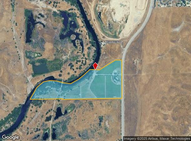
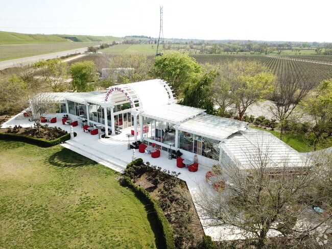
14439 N Friant Rd
Fresno, CA
Sumner Peck Ranch Inc
300-250-30
76.20 AC PAR IN N1/2 OF S1/2 SEC 25 T11S R20E
Vineyard
Fresno
AE
California
06019C1030H
76.20 AC
2025
E Outlying Fresno County
2025
Fresno
005529
DEMOGRAPHICS near 14439 N Friant Rd
1 Mile
3 Mile
5 Mile
2024 Total Population
46
3,179
31,677
2029 Population
46
3,374
33,298
Pop Growth 2024-2029
0.00%
+ 6.13%
+ 5.12%
Average Age
44
41
40
2024 Total Households
17
1,139
11,033
HH Growth 2024-2029
0.00%
+ 6.23%
+ 5.18%
Median Household Inc
$158,333
$107,673
$125,430
Avg Household Size
2.50
2.70
2.80
2024 Avg HH Vehicles
3.00
2.00
2.00
Median Home Value
$750,000
$675,512
$554,448
Median Year Built
1992
2006
2000
Nearby Places
- Restaurants
- Banks
- Shops
- Fitness
- Groceries
PUBLIC TRANSPORTATION
AIRPORT
Fresno Yosemite International
DRIVE
WALK
Distance
Fresno Yosemite International
31 min
14.1 mi
Freight Ports
Port of Stockton
DRIVE
WALK
Distance
Port of Stockton
171 min
133.9 mi
SALE & LEASE HISTORY
LISTING DATE
SALE/LEASE

Mar 11, 2019
For Sale
Feb 10, 2020
For Sale
Nearby Properties
Address
Land Use
TOTAL SIZE
Lot Size
Zoning
Address
Land Use
TOTAL SIZE
Lot Size
Zoning
1,403 SF
234.59 AC
ARF
Address
Land Use
TOTAL SIZE
Lot Size
Zoning
35,045 SF
17.59 AC
AE20
Address
Land Use
TOTAL SIZE
Lot Size
Zoning
15,469 SF
44.74 AC
AE20
Address
Land Use
TOTAL SIZE
Lot Size
Zoning
7,442 SF
23.42 AC
AE20
Address
Land Use
TOTAL SIZE
Lot Size
Zoning
8,235 SF
2.53 AC
Address
Land Use
TOTAL SIZE
Lot Size
Zoning
7,472 SF
2 AC
RR
Address
Land Use
TOTAL SIZE
Lot Size
Zoning
14,904 SF
158.05 AC
AE20
Address
Land Use
TOTAL SIZE
Lot Size
Zoning
7,715 SF
2.08 AC
RR
Address
Land Use
TOTAL SIZE
Lot Size
Zoning
5,815 SF
10 AC
AE20
Address
Land Use
TOTAL SIZE
Lot Size
Zoning
6,500 SF
0.56 AC
R1B
Address
Land Use
TOTAL SIZE
Lot Size
Zoning
5,749 SF
6.04 AC
AE20
Address
Land Use
TOTAL SIZE
Lot Size
Zoning
2,292 SF
71.10 AC
ARV-20
Address
Land Use
TOTAL SIZE
Lot Size
Zoning
11,376 SF
1.06 AC
C6
Address
Land Use
TOTAL SIZE
Lot Size
Zoning
4,632 SF
0.39 AC
Address
Land Use
TOTAL SIZE
Lot Size
Zoning
0.42 AC
R1
Address
Land Use
TOTAL SIZE
Lot Size
Zoning
4,632 SF
0.21 AC
Address
Land Use
TOTAL SIZE
Lot Size
Zoning
1,192 SF
21.18 AC
AE20
Address
Land Use
TOTAL SIZE
Lot Size
Zoning
535.75 AC
AE20
Address
Land Use
TOTAL SIZE
Lot Size
Zoning
2.70 AC
AE20
Address
Land Use
TOTAL SIZE
Lot Size
Zoning
2,724 SF
78.19 AC
AE20
Address
Land Use
TOTAL SIZE
Lot Size
Zoning
2 AC
RR
Address
Land Use
TOTAL SIZE
Lot Size
Zoning
4,771 SF
0.13 AC
C1
Address
Land Use
TOTAL SIZE
Lot Size
Zoning
18.90 AC
AE20
Address
Land Use
TOTAL SIZE
Lot Size
Zoning
4,120 SF
3.42 AC
RRS
Address
Land Use
TOTAL SIZE
Lot Size
Zoning
2,136 SF
64.18 AC
Address
Land Use
TOTAL SIZE
Lot Size
Zoning
0.18 AC
RS-4
Address
Land Use
TOTAL SIZE
Lot Size
Zoning
5.09 AC
AE20
Address
Land Use
TOTAL SIZE
Lot Size
Zoning
25.25 AC
AE20
The World's #1 Commercial Real Estate Marketplace
Connect with us
© 2025 CoStar Group
The information above has been obtained from sources believed reliable. While we do not doubt its accuracy we have not verified it and make no guarantee, warranty or representation about it. It is your responsibility to independently confirm its accuracy and completeness. Any projections, opinions, assumptions, or estimates used are for example only and do not represent the current or future performance of the property. The value of this transaction to you depends on tax and other factors which should be evaluated by your tax, financial, and legal advisors. You and your advisors should conduct a careful, independent investigation of the property to determine to your satisfaction the suitability of the property for your needs.