Property Record
1444 Scribner Ave Nw, Grand Rapids, MI 49504
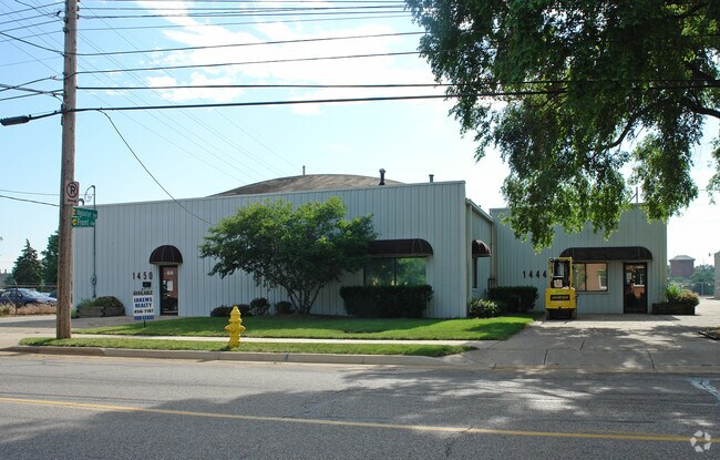

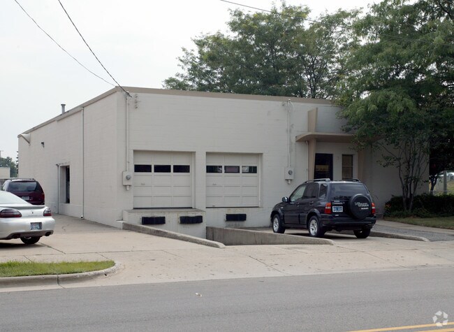
Property Detail
1444 Scribner Ave Nw
41-13-13-452-001
LOTS 62 & 64* LEONARD & COMPANY S ADDITION
Officebuilding
Kent
TN-TCC
Michigan
D Areas with possible but undetermined flood hazards.
62,64
2025
0.30 AC
2025
Central Grand Rapids
000800
West Michigan
4,116 SF
Grand Rapids-Wyoming-Kentwood, MI
NEARBY LISTINGS FOR SALE OR LEASE
DEMOGRAPHICS near 1444 Scribner Ave Nw
1 mile
3 mile
5 mile
2025 Total Population
18,106
111,480
229,721
2030 Population
19,082
113,885
234,140
Pop Growth 2025-2030
+ 5.39%
+ 2.16%
+ 1.92%
Average Age
34
37
37
2025 Total Households
7,202
48,483
92,433
HH Growth 2025-2030
+ 5.53%
+ 2.25%
+ 2.09%
Median Household Inc
$53,208
$68,107
$70,849
Avg Household Size
2.40
2.20
2.40
2025 Avg HH Vehicles
2.00
2.00
2.00
Median Home Value
$207,775
$251,895
$262,076
Median Year Built
1948
1952
1957
Nearby Places
Map Layers
Map Styles
 Street
 Aerial
Layers
 Traffic
 Biking
Places
Listings with unknown addresses are not visible on the map
- Restaurants
- Banks
- Shops
- Fitness
- Groceries
PUBLIC TRANSPORTATION
COMMUTER RAIL
Drive
Walk
Distance
6 min
2.8 mi
AIRPORT
Gerald R Ford International
Drive
Walk
Distance
Gerald R Ford International
25 min
16.1 mi
Nearby Properties
Address
Land Use
TOTAL SIZE
Lot Size
Zoning
Address
Land Use
TOTAL SIZE
Lot Size
Zoning
226,925 SF
1.32 AC
TN-CC
Address
Land Use
TOTAL SIZE
Lot Size
Zoning
557,931 SF
2.12 AC
TN-CC
Address
Land Use
TOTAL SIZE
Lot Size
Zoning
537,080 SF
46.61 AC
RPUD - 2
Address
Land Use
TOTAL SIZE
Lot Size
Zoning
546,366 SF
28.40 AC
MH
Address
Land Use
TOTAL SIZE
Lot Size
Zoning
265,905 SF
1.99 AC
TN-CC
Address
Land Use
TOTAL SIZE
Lot Size
Zoning
211,760 SF
TN-CC
Address
Land Use
TOTAL SIZE
Lot Size
Zoning
768,153 SF
3.20 AC
TN-CC
Address
Land Use
TOTAL SIZE
Lot Size
Zoning
347,500 SF
1.51 AC
TN-CC
Address
Land Use
TOTAL SIZE
Lot Size
Zoning
491,288 SF
2.79 AC
SD-PRD
Address
Land Use
TOTAL SIZE
Lot Size
Zoning
96,528 SF
9.88 AC
SD-NOS
Address
Land Use
TOTAL SIZE
Lot Size
Zoning
451,792 SF
32.60 AC
ARM - MULT
Address
Land Use
TOTAL SIZE
Lot Size
Zoning
138,122 SF
1.01 AC
TN-CC
Address
Land Use
TOTAL SIZE
Lot Size
Zoning
455,639 SF
42.06 AC
MH
Address
Land Use
TOTAL SIZE
Lot Size
Zoning
Address
Land Use
TOTAL SIZE
Lot Size
Zoning
281,488 SF
1.20 AC
TN-CC
Address
Land Use
TOTAL SIZE
Lot Size
Zoning
145,306 SF
0.75 AC
TN-CC
Address
Land Use
TOTAL SIZE
Lot Size
Zoning
164,591 SF
1.28 AC
TN-CC
Address
Land Use
TOTAL SIZE
Lot Size
Zoning
Address
Land Use
TOTAL SIZE
Lot Size
Zoning
201,100 SF
0.90 AC
TN-CC
Address
Land Use
TOTAL SIZE
Lot Size
Zoning
18.07 AC
MON-LDR
Address
Land Use
TOTAL SIZE
Lot Size
Zoning
94,556 SF
1.03 AC
TN-TCC
Address
Land Use
TOTAL SIZE
Lot Size
Zoning
88,327 SF
2.74 AC
TN-CC
Address
Land Use
TOTAL SIZE
Lot Size
Zoning
366,447 SF
2.71 AC
TN-CC
Address
Land Use
TOTAL SIZE
Lot Size
Zoning
18.65 AC
MCN-MDR
Address
Land Use
TOTAL SIZE
Lot Size
Zoning
363,503 SF
2.20 AC
TN-CC
Address
Land Use
TOTAL SIZE
Lot Size
Zoning
68,560 SF
2.76 AC
TN-TCC
Address
Land Use
TOTAL SIZE
Lot Size
Zoning
254,941 SF
0.79 AC
TN-CC
Address
Land Use
TOTAL SIZE
Lot Size
Zoning
109,482 SF
1.35 AC
SD-PRD
Address
Land Use
TOTAL SIZE
Lot Size
Zoning
310,790 SF
0.66 AC
TN-CC
Address
Land Use
TOTAL SIZE
Lot Size
Zoning
33.06 AC
R-3
The World's #1 Commercial Real Estate Marketplace
Connect with us
© 2026 CoStar Group
The information above has been obtained from sources believed reliable. While we do not doubt its accuracy we have not verified it and make no guarantee, warranty or representation about it. It is your responsibility to independently confirm its accuracy and completeness. Any projections, opinions, assumptions, or estimates used are for example only and do not represent the current or future performance of the property. The value of this transaction to you depends on tax and other factors which should be evaluated by your tax, financial, and legal advisors. You and your advisors should conduct a careful, independent investigation of the property to determine to your satisfaction the suitability of the property for your needs.