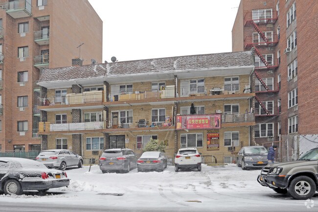
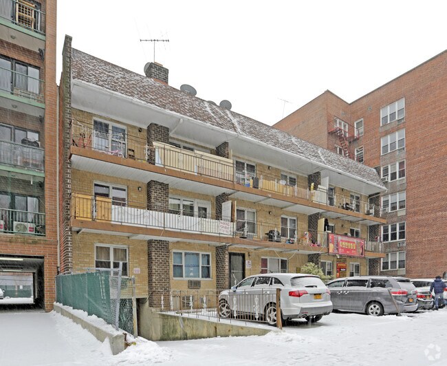
Property Record
14440 Roosevelt Ave, Flushing, NY 11354

Property Detail
14440 Roosevelt Ave
05025-0025
LAND EASEMENT HELD BY LIRR
Apartment
Queens
R6
New York
B and X Area of moderate flood hazard, usually the area between the limits of the 100-year and 500-year floods.
25
2025
0.25 AC
2026
Murray Hill
086300
Long Island (New York)
21,426 SF
New York-Jersey City-White Plains, NY-NJ
NEARBY LISTINGS FOR SALE OR LEASE
DEMOGRAPHICS near 14440 Roosevelt Ave
1 mile
3 mile
5 mile
2025 Total Population
148,692
626,099
1,499,621
2030 Population
150,449
619,157
1,478,545
Pop Growth 2025-2030
+ 1.18%
(1.11%)
(1.41%)
Average Age
45
43
42
2025 Total Households
53,100
212,346
516,006
HH Growth 2025-2030
+ 0.83%
(1.29%)
(1.67%)
Median Household Inc
$53,526
$74,440
$77,495
Avg Household Size
2.70
2.80
2.70
2025 Avg HH Vehicles
1.00
1.00
1.00
Median Home Value
$565,077
$710,596
$702,060
Median Year Built
1962
1956
1954
Nearby Places
Map Layers
Map Styles
 Street
 Aerial
Layers
 Traffic
 Biking
Places
Listings with unknown addresses are not visible on the map
- Restaurants
- Banks
- Shops
- Fitness
- Groceries
PUBLIC TRANSPORTATION
TRANSIT/SUBWAY
Flushing-Main Street (7 - New York MTA Subway (The Subway))
Drive
Walk
Distance
Flushing-Main Street (7 - New York MTA Subway (The Subway))
1 min
10 min
0.5 mi
COMMUTER RAIL
Murray Hill Station (Port Washington Branch - Long Island Rail Road)
Drive
Walk
Distance
Murray Hill Station (Port Washington Branch - Long Island Rail Road)
1 min
7 min
0.4 mi
Flushing-Main Street Station (Port Washington Branch - Long Island Rail Road)
Drive
Walk
Distance
Flushing-Main Street Station (Port Washington Branch - Long Island Rail Road)
2 min
13 min
0.7 mi
AIRPORT
LaGuardia
Drive
Walk
Distance
LaGuardia
10 min
3.9 mi
John F Kennedy International
Drive
Walk
Distance
John F Kennedy International
16 min
10.6 mi
Newark Liberty International
Drive
Walk
Distance
Newark Liberty International
38 min
24.8 mi
Freight Ports
NY - Red Hook Container Terminal
Drive
Walk
Distance
NY - Red Hook Container Terminal
23 min
13.6 mi
Nearby Properties
Address
Land Use
TOTAL SIZE
Lot Size
Zoning
Address
Land Use
TOTAL SIZE
Lot Size
Zoning
23.16 AC
PARK
Address
Land Use
TOTAL SIZE
Lot Size
Zoning
2,078,606 SF
58.93 AC
R4
Address
Land Use
TOTAL SIZE
Lot Size
Zoning
1,258,350 SF
410.24 AC
PARK
Address
Land Use
TOTAL SIZE
Lot Size
Zoning
1,292,074 SF
C4-2F
Address
Land Use
TOTAL SIZE
Lot Size
Zoning
15,000 SF
255.27 AC
PARK
Address
Land Use
TOTAL SIZE
Lot Size
Zoning
4,050 SF
113.40 AC
PARK
Address
Land Use
TOTAL SIZE
Lot Size
Zoning
4,800 SF
80.10 AC
PARK
Address
Land Use
TOTAL SIZE
Lot Size
Zoning
332,266 SF
12.57 AC
M2-1
Address
Land Use
TOTAL SIZE
Lot Size
Zoning
1,186,778 SF
31.45 AC
R4
Address
Land Use
TOTAL SIZE
Lot Size
Zoning
577,654 SF
5.38 AC
R6
Address
Land Use
TOTAL SIZE
Lot Size
Zoning
521,944 SF
16.68 AC
R4
Address
Land Use
TOTAL SIZE
Lot Size
Zoning
377,896 SF
11.36 AC
R3-2
Address
Land Use
TOTAL SIZE
Lot Size
Zoning
612,205 SF
10.08 AC
C4-4
Address
Land Use
TOTAL SIZE
Lot Size
Zoning
226,990 SF
0.72 AC
C4-3
Address
Land Use
TOTAL SIZE
Lot Size
Zoning
250,577 SF
23.17 AC
M2-1
Address
Land Use
TOTAL SIZE
Lot Size
Zoning
198,298 SF
13.93 AC
C4-1
Address
Land Use
TOTAL SIZE
Lot Size
Zoning
186,843 SF
5.37 AC
R2A
Address
Land Use
TOTAL SIZE
Lot Size
Zoning
382,302 SF
6.23 AC
R2A
Address
Land Use
TOTAL SIZE
Lot Size
Zoning
2,828 SF
78.05 AC
PARK
Address
Land Use
TOTAL SIZE
Lot Size
Zoning
533,460 SF
27.75 AC
M1-1
Address
Land Use
TOTAL SIZE
Lot Size
Zoning
454,631 SF
24.61 AC
M1-1
Address
Land Use
TOTAL SIZE
Lot Size
Zoning
192,200 SF
9.70 AC
R4
Address
Land Use
TOTAL SIZE
Lot Size
Zoning
614,916 SF
28.10 AC
R4
Address
Land Use
TOTAL SIZE
Lot Size
Zoning
4,279,575 SF
144.16 AC
PARK
Address
Land Use
TOTAL SIZE
Lot Size
Zoning
207,407 SF
3.73 AC
R6B
Address
Land Use
TOTAL SIZE
Lot Size
Zoning
454,645 SF
0.95 AC
C4-4
Address
Land Use
TOTAL SIZE
Lot Size
Zoning
202,615 SF
1.33 AC
R7-1
Address
Land Use
TOTAL SIZE
Lot Size
Zoning
251,467 SF
2.02 AC
C4-2
Address
Land Use
TOTAL SIZE
Lot Size
Zoning
456,881 SF
1.43 AC
C4-4
Address
Land Use
TOTAL SIZE
Lot Size
Zoning
15.83 AC
M2-1
The World's #1 Commercial Real Estate Marketplace
Connect with us
© 2026 CoStar Group
The information above has been obtained from sources believed reliable. While we do not doubt its accuracy we have not verified it and make no guarantee, warranty or representation about it. It is your responsibility to independently confirm its accuracy and completeness. Any projections, opinions, assumptions, or estimates used are for example only and do not represent the current or future performance of the property. The value of this transaction to you depends on tax and other factors which should be evaluated by your tax, financial, and legal advisors. You and your advisors should conduct a careful, independent investigation of the property to determine to your satisfaction the suitability of the property for your needs.