Property Record
14442 Walnut Grove Thornton Rd, Walnut Grove, CA 95690
NEARBY LISTINGS FOR SALE OR LEASE
Property Detail
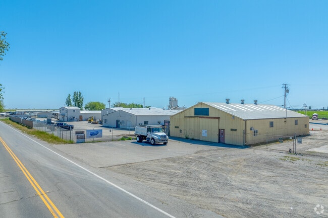
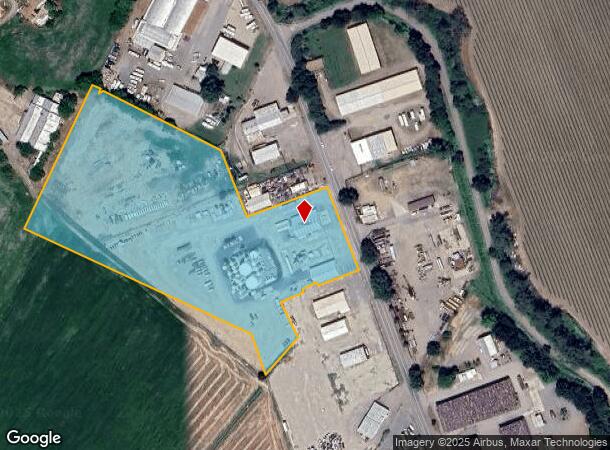
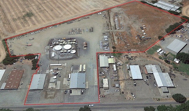
14442 Walnut Grove Thornton Rd
156-0010-087
LONG LEGAL TO BE UPDATED FROM 20120105 433
Multitenantindustrial
Sacramento
AE
California
06067C0560H
9.66 AC
2024
Outer Sacramento Cnty
2025
Sacramento
009900
Sacramento-Roseville-Folsom, CA
56,352 SF
DEMOGRAPHICS near 14442 Walnut Grove Thornton Rd
1 Mile
3 Mile
5 Mile
2024 Total Population
713
1,712
2,244
2029 Population
670
1,627
2,143
Pop Growth 2024-2029
(6.03%)
(4.96%)
(4.50%)
Average Age
41
42
42
2024 Total Households
257
629
813
HH Growth 2024-2029
(6.61%)
(5.09%)
(4.67%)
Median Household Inc
$64,955
$64,472
$63,970
Avg Household Size
2.70
2.60
2.70
2024 Avg HH Vehicles
2.00
2.00
2.00
Median Home Value
$716,019
$684,739
$671,568
Median Year Built
1957
1965
1965
Nearby Places
Map Layers
Map Styles
 Street
 Aerial
- Restaurants
- Banks
- Shops
- Fitness
- Groceries
PUBLIC TRANSPORTATION
AIRPORT
Stockton Metro
DRIVE
WALK
Distance
Stockton Metro
43 min
33.0 mi
Freight Ports
Port of Stockton
DRIVE
WALK
Distance
Port of Stockton
33 min
25.4 mi
SALE & LEASE HISTORY
LISTING DATE
SALE/LEASE

Sep 15, 2023
For Sale
Jan 24, 2024
For Lease
Nearby Properties
Address
Land Use
TOTAL SIZE
Lot Size
Zoning
Address
Land Use
TOTAL SIZE
Lot Size
Zoning
9.07 AC
AG40
Address
Land Use
TOTAL SIZE
Lot Size
Zoning
2,272 SF
579.06 AC
AG40
Address
Land Use
TOTAL SIZE
Lot Size
Zoning
1,687 SF
658.77 AC
AG40
Address
Land Use
TOTAL SIZE
Lot Size
Zoning
6,798 SF
40 AC
AG-80
Address
Land Use
TOTAL SIZE
Lot Size
Zoning
2,338 SF
59.20 AC
AG-40
Address
Land Use
TOTAL SIZE
Lot Size
Zoning
3,024 SF
159.63 AC
AG-80
Address
Land Use
TOTAL SIZE
Lot Size
Zoning
2,492 SF
214.26 AC
DW-S AG-80
Address
Land Use
TOTAL SIZE
Lot Size
Zoning
416 AC
AG40
Address
Land Use
TOTAL SIZE
Lot Size
Zoning
2,700 SF
91.93 AC
AG-20
Address
Land Use
TOTAL SIZE
Lot Size
Zoning
768.22 AC
AG-80
Address
Land Use
TOTAL SIZE
Lot Size
Zoning
720.47 AC
AG-80
Address
Land Use
TOTAL SIZE
Lot Size
Zoning
936 SF
120.76 AC
AG-80
Address
Land Use
TOTAL SIZE
Lot Size
Zoning
4.52 AC
M-2
Address
Land Use
TOTAL SIZE
Lot Size
Zoning
1,548 SF
39.45 AC
AG-20
Address
Land Use
TOTAL SIZE
Lot Size
Zoning
1,131 SF
82.97 AC
AG40
Address
Land Use
TOTAL SIZE
Lot Size
Zoning
133.45 AC
AG-80
Address
Land Use
TOTAL SIZE
Lot Size
Zoning
512 SF
4.03 AC
AG40
Address
Land Use
TOTAL SIZE
Lot Size
Zoning
40 AC
AG-40 LC
Address
Land Use
TOTAL SIZE
Lot Size
Zoning
7,950 SF
35 AC
AG-20
Address
Land Use
TOTAL SIZE
Lot Size
Zoning
2,918 SF
100 AC
AG-80
Address
Land Use
TOTAL SIZE
Lot Size
Zoning
29,280 SF
5.10 AC
M-2 AG-20
Address
Land Use
TOTAL SIZE
Lot Size
Zoning
64.75 AC
AG-40
Address
Land Use
TOTAL SIZE
Lot Size
Zoning
100.15 AC
AG-80
Address
Land Use
TOTAL SIZE
Lot Size
Zoning
2,212 SF
99.34 AC
AG-80
Address
Land Use
TOTAL SIZE
Lot Size
Zoning
47.44 AC
AG-20
Address
Land Use
TOTAL SIZE
Lot Size
Zoning
16,662 SF
7.96 AC
DW LC AR-5
Address
Land Use
TOTAL SIZE
Lot Size
Zoning
54.57 AC
AG-80
Address
Land Use
TOTAL SIZE
Lot Size
Zoning
4,292 SF
19.95 AC
AG-40
Address
Land Use
TOTAL SIZE
Lot Size
Zoning
42.57 AC
AG40
The World's #1 Commercial Real Estate Marketplace
Connect with us
© 2026 CoStar Group
The information above has been obtained from sources believed reliable. While we do not doubt its accuracy we have not verified it and make no guarantee, warranty or representation about it. It is your responsibility to independently confirm its accuracy and completeness. Any projections, opinions, assumptions, or estimates used are for example only and do not represent the current or future performance of the property. The value of this transaction to you depends on tax and other factors which should be evaluated by your tax, financial, and legal advisors. You and your advisors should conduct a careful, independent investigation of the property to determine to your satisfaction the suitability of the property for your needs.