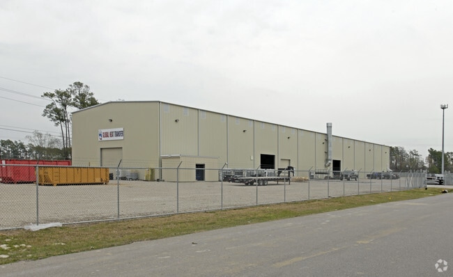
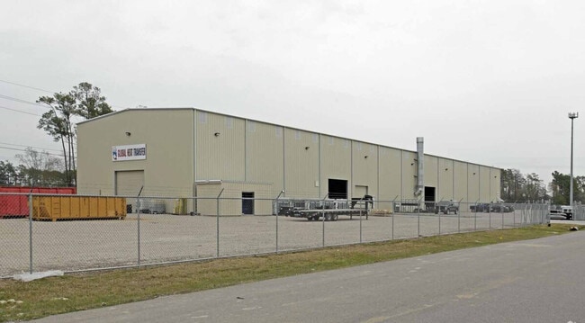
Property Record
14446 Smith Rd, Humble, TX 77396


Property Detail
14446 Smith Rd
1330900010002
RES A1 BLK 1 BELTWAY FIFTY NINE NORTH PARTNERS
Lightindustrial
HARRIS
B and X Area of moderate flood hazard, usually the area between the limits of the 100-year and 500-year floods.
Texas
2024
3 AC
2025
Northeast Hwy 90
232202
Houston
20,026 SF
Houston-Pasadena-The Woodlands, TX
NEARBY LISTINGS FOR SALE OR LEASE
DEMOGRAPHICS near 14446 Smith Rd
1 mile
3 mile
5 mile
2025 Total Population
8,282
63,515
153,076
2030 Population
8,658
67,403
163,385
Pop Growth 2025-2030
+ 4.54%
+ 6.12%
+ 6.73%
Average Age
34
34
35
2025 Total Households
2,606
20,303
47,842
HH Growth 2025-2030
+ 4.34%
+ 6.23%
+ 6.90%
Median Household Inc
$102,782
$62,800
$59,810
Avg Household Size
3.20
3.10
3.10
2025 Avg HH Vehicles
2.00
2.00
2.00
Median Home Value
$289,442
$240,333
$214,117
Median Year Built
2003
1998
1988
Nearby Places
Map Layers
Map Styles
 Street
 Aerial
Transit
 Traffic
 Biking
Places
Listings with unknown addresses are not visible on the map
- Restaurants
- Banks
- Shops
- Fitness
- Groceries
PUBLIC TRANSPORTATION
AIRPORT
George Bush Intcntl/Houston
Drive
Walk
Distance
George Bush Intcntl/Houston
11 min
7.0 mi
William P Hobby
Drive
Walk
Distance
William P Hobby
42 min
26.2 mi
Freight Ports
Port of Houston
Drive
Walk
Distance
Port of Houston
31 min
19.8 mi
SALE & LEASE HISTORY
LISTING DATE
SALE/LEASE

Aug 30, 2025
For Lease
Nearby Properties
Address
Land Use
TOTAL SIZE
Lot Size
Zoning
Address
Land Use
TOTAL SIZE
Lot Size
Zoning
785,390 SF
66.02 AC
Address
Land Use
TOTAL SIZE
Lot Size
Zoning
514,500 SF
40.85 AC
Address
Land Use
TOTAL SIZE
Lot Size
Zoning
567,528 SF
76.97 AC
Address
Land Use
TOTAL SIZE
Lot Size
Zoning
523,480 SF
29.22 AC
Address
Land Use
TOTAL SIZE
Lot Size
Zoning
306,652 SF
10.67 AC
Address
Land Use
TOTAL SIZE
Lot Size
Zoning
379,570 SF
30.12 AC
Address
Land Use
TOTAL SIZE
Lot Size
Zoning
320,798 SF
14.25 AC
Address
Land Use
TOTAL SIZE
Lot Size
Zoning
431,400 SF
30.88 AC
Address
Land Use
TOTAL SIZE
Lot Size
Zoning
338,700 SF
22.99 AC
Address
Land Use
TOTAL SIZE
Lot Size
Zoning
382,632 SF
22.14 AC
Address
Land Use
TOTAL SIZE
Lot Size
Zoning
361,919 SF
23.59 AC
Address
Land Use
TOTAL SIZE
Lot Size
Zoning
260,427 SF
4.50 AC
Address
Land Use
TOTAL SIZE
Lot Size
Zoning
73,500 SF
115.96 AC
Address
Land Use
TOTAL SIZE
Lot Size
Zoning
449,858 SF
22.20 AC
Address
Land Use
TOTAL SIZE
Lot Size
Zoning
207,720 SF
12.33 AC
Address
Land Use
TOTAL SIZE
Lot Size
Zoning
321,604 SF
16.68 AC
Address
Land Use
TOTAL SIZE
Lot Size
Zoning
246,712 SF
13.33 AC
Address
Land Use
TOTAL SIZE
Lot Size
Zoning
276,464 SF
18.79 AC
Address
Land Use
TOTAL SIZE
Lot Size
Zoning
315,434 SF
13.16 AC
Address
Land Use
TOTAL SIZE
Lot Size
Zoning
262,010 SF
12.64 AC
Address
Land Use
TOTAL SIZE
Lot Size
Zoning
264,300 SF
15.89 AC
Address
Land Use
TOTAL SIZE
Lot Size
Zoning
170,407 SF
26.31 AC
Address
Land Use
TOTAL SIZE
Lot Size
Zoning
281,252 SF
8 AC
Address
Land Use
TOTAL SIZE
Lot Size
Zoning
259,500 SF
12.28 AC
Address
Land Use
TOTAL SIZE
Lot Size
Zoning
314,294 SF
29.50 AC
Address
Land Use
TOTAL SIZE
Lot Size
Zoning
181,720 SF
15.28 AC
Address
Land Use
TOTAL SIZE
Lot Size
Zoning
159,840 SF
16.13 AC
Address
Land Use
TOTAL SIZE
Lot Size
Zoning
113,604 SF
10.70 AC
Address
Land Use
TOTAL SIZE
Lot Size
Zoning
160,930 SF
9.18 AC
Address
Land Use
TOTAL SIZE
Lot Size
Zoning
182,000 SF
8.88 AC
The World's #1 Commercial Real Estate Marketplace
Connect with us
© 2026 CoStar Group
The information above has been obtained from sources believed reliable. While we do not doubt its accuracy we have not verified it and make no guarantee, warranty or representation about it. It is your responsibility to independently confirm its accuracy and completeness. Any projections, opinions, assumptions, or estimates used are for example only and do not represent the current or future performance of the property. The value of this transaction to you depends on tax and other factors which should be evaluated by your tax, financial, and legal advisors. You and your advisors should conduct a careful, independent investigation of the property to determine to your satisfaction the suitability of the property for your needs.